Login
Register


RMG
Richard B Russell Regional - J H Towers Field Airport
Official FAA Data Effective 2024-04-18 0901Z
Chart Supplement

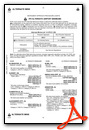
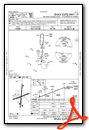
KRMG Airport Diagram

VFR Chart of KRMG
Sectional Charts at SkyVector.com
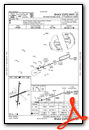
IFR Chart of KRMG
Enroute Charts at SkyVector.com
Location Information for KRMG
Coordinates: N34°21.05' / W85°9.52'Located 06 miles N of Rome, Georgia on 985 acres of land. View all Airports in Georgia.
Surveyed Elevation is 644 feet MSL.
Operations Data
|
|
Airport Communications
| ASOS: | 119.925 Tel. 706-235-3335 |
|---|---|
| CTAF: | 122.725 |
| UNICOM: | 122.725 |
| AWOS-3 at CZL (12.7 NE): | 119.975 706-602-5906 |
| AWOS-3PT at VPC (20.8 SE): | 120.525 770-607-7782 |
| AWOS-3 at 9A5 (21.1 N): | 119.775 706-639-1976 |
- APCH/DEP SVC PRVDD BY ATLANTA ARTCC ON FREQS 124.5/270.325 (GADSDEN RCAG).
Nearby Navigation Aids
|
| ||||||||||||||||||||||||||||||||||||||||||||||||||||||||||||


Runway 01/19
| Dimensions: | 6006 x 150 feet / 1831 x 46 meters | |
|---|---|---|
| Surface: | Asphalt / Grooved in Good Condition | |
| Weight Limits: | S-52, D-57, ST-114 | |
| Edge Lighting: | High Intensity | |
| Runway 01 | Runway 19 | |
| Coordinates: | N34°20.57' / W85°9.57' | N34°21.55' / W85°9.46' |
| Elevation: | 632.3 | 624.4 |
| Traffic Pattern: | Left | Left |
| Runway Heading: | 5° True | 185° True |
| Markings: | Precision Instrument in fair condition. | Precision Instrument in fair condition. |
| Glide Slope Indicator | P4L (3.00° Glide Path Angle) | P4L (3.00° Glide Path Angle) |
| Approach Lights: | MALSR 1,400 Foot Medium-intensity Approach Lighting System with runway alignment indicator lights. | |
| Obstacles: | 106 ft Trees 2867 ft from runway, 666 ft right of center | 136 ft Trees 4562 ft from runway, 340 ft right of center |
Runway 07/25
| Dimensions: | 4495 x 100 feet / 1370 x 30 meters | |
|---|---|---|
| Surface: | Asphalt in Excellent Condition | |
| Weight Limits: | S-16, D-30 | |
| Runway 07 | Runway 25 | |
| Coordinates: | N34°20.90' / W85°9.95' | N34°21.16' / W85°9.11' |
| Elevation: | 644.1 | 626.0 |
| Traffic Pattern: | Left | Left |
| Runway Heading: | 70° True | 250° True |
| Displaced Threshold: | 115 Feet | |
| Declared Distances: | TORA:4495 TODA:4495 ASDA:4495 LDA:4380 | TORA:4495 TODA:4495 ASDA:4495 LDA:4495 |
| Markings: | Non-Precision Instrument in good condition. | Non-Precision Instrument in good condition. |
| Obstacles: | 15 ft Road 260 ft from runway, 300 ft right of center RWY 07 - APCH RATIO 13:1 AT DSPLCD THLD; 67 FT TREES 1071 FT FM DSPLCD THLD 350 FT L. |
51 ft Tree 975 ft from runway, 361 ft left of center |
Services Available
| Fuel: | 100LL (blue), Jet A+ |
|---|---|
| Transient Storage: | Tiedowns |
| Airframe Repair: | MAJOR |
| Engine Repair: | MAJOR |
| Bottled Oxygen: | NONE |
| Bulk Oxygen: | NONE |
| Other Services: | PILOT INSTRUCTION,AIRCRAFT RENTAL |
Ownership Information
| Ownership: | Publicly owned | |
|---|---|---|
| Owner: | FLOYD COUNTY | |
| PO BOX 946 | ||
| ROME, GA 30161 | ||
| 706-295-7835 | ||
| Manager: | JOHN CARROLL | |
| 304 RUSSELL FIELD RD NE | ||
| ROME, GA 30161 | ||
| 706-295-7835 | ||
Operational Statistics
| Single Engine Aircraft Based on Field: | 56 | Statistics collected for 12 month period ending 2022-12-31 | |
|---|---|---|---|
| Multi-Engine Aircraft Based on Field: | 11 | Annual Commercial Operations: | none |
| Jet Aircraft Based on Field: | 1 | Annual Commuter Operations: | none |
| Helicopters Based on Field: | none | Annual Air Taxi Operations: | none |
| Military Aircraft Based on Field: | none | Annual Military Operations: | 1000 |
| Gliders Based on Field: | none | Annual GA Local Operations: | 30000 |
| Ultralights Based on Field: | 1 | Annual GA Itinerant Operations: | 30000 |
Other Remarks
- ULTRALIGHT ACTIVITY ON & INVOF ARPT.
- DEER ON INVOF ARPT.
- MIL AIR CARGO DROP (C130 ACFT) IN PROGRESS 1830-2030 TUE AND THU AT NE END OF RWY 07/25.
- GCO AVBL ON FREQ 121.725 THRU ATL CLEARANCE DELIVERY.
- FOR CD IF UNA TO CTC ON FSS FREQ, CTC ATLANTA ARTCC AT 770-210-7692.
- ACTVT MALSR RWY 01; PAPI RWY 01 & 19; HIRL RWY 01/19 - CTAF.
Weather Minimums

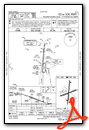
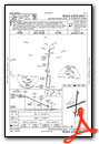
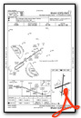
Instrument Approach Procedure (IAP) Charts
Nearby Airports with Instrument Procedures
| ID | Name | Heading / Distance | ||
|---|---|---|---|---|
 |
KCZL | Tom B David Field Airport | 060° | 12.6 |
|
4A4 | Polk County/Cornelius Moore Field Airport | 178° | 19.9 |
|
KVPC | Cartersville Airport | 131° | 20.6 |
|
9A5 | Barwick Lafayette Airport | 342° | 21.3 |
|
KDNN | Dalton Municipal Airport | 032° | 26.5 |
|
KPYP | Centre-Piedmont-Cherokee County Regional Airport | 235° | 27.4 |
|
KPUJ | Paulding Northwest Atlanta Airport | 157° | 28.4 |
|
4A9 | Isbell Field Airport | 284° | 28.9 |
|
KRYY | Cobb County International/Mccollum Field Airport | 125° | 34.5 |
|
KJZP | Pickens County Airport | 079° | 35.4 |
|
49A | Gilmer County Airport | 061° | 35.5 |
|
KCNI | Cherokee County Regional Airport | 093° | 36.7 |
Airport Images
Do you have a recent image of this airport? Upload it here!


