Login
Register


TUL
Tulsa International Airport
Official FAA Data Effective 2025-12-25 0901Z
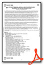
From the Flight Deck
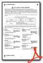
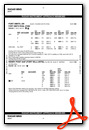
Chart Supplement

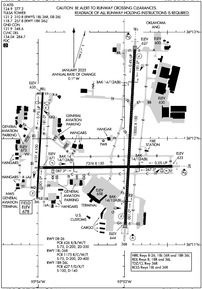
KTUL Airport Diagram
VFR Chart of KTUL
Sectional Charts at SkyVector.com
IFR Chart of KTUL
Enroute Charts at SkyVector.com
Location Information for KTUL
Coordinates: N36°11.90' / W95°53.29'Located 05 miles NE of Tulsa, Oklahoma on 4360 acres of land. View all Airports in Oklahoma.
Surveyed Elevation is 677 feet MSL.
Operations Data
|
|
Airport Communications
| D-ATIS: | 124.9 (918-831-6718) 377.2 (918-831-6718) |
|---|---|
| ASOS: | Tel. 539-399-0187 |
| TULSA TOWER: | 118.7 ;RWY 18R/36L 121.2 ;RWY 08/26, 18L/36R 257.8 ;RWY 18R/36L 310.8 ;RWY 08/26, 18L/36R |
| TULSA GROUND: | 121.9 348.6 |
| TULSA APPROACH: | 119.1 ;355-174 124.0 ;175-354 338.3 ;175-354 360.825 ;355-174 |
| TULSA DEPARTURE: | 119.1 ;355-174 124.0 ;175-354 338.3 ;175-354 360.825 ;355-174 |
| IC: | 124.0 ;175-354 338.3 ;175-354 |
| CLEARANCE DELIVERY: | 134.05 284.7 |
| FINAL: | 119.85 ;355-174 132.1 ;175-354 239.275 319.9 ;175-354 381.2 ;355-175 |
| EMERG: | 121.5 243.0 |
| ANG OPS: | 335.475 381.1 |
| CLASS C: | 119.1 ;355-174 124.0 ;175-354 338.3 ;175-354 360.825 ;355-174 |
| NG OPS: | 46.9FM |
| PRE TAXI CLNC: | 134.05 284.7 |
| VINTA STAR: | 119.1 360.825 |
| PTD: | 260.4 |
| TULSA DP: | 124.0 338.3 |
| UNICOM: | 122.950 |
| ASOS at RVS (10.6 SW): | 126.5 918-299-0740 |
| ATIS at RVS (10.6 SW): | 126.5 |
| AWOS-3T at OWP (12.8 W): | 118.325 918-246-2635 |
Nearby Navigation Aids
|
| ||||||||||||||||||||||||||||||||||||||||||||||||||||||||||||


Runway 18L/36R
| Dimensions: | 10000 x 150 feet / 3048 x 46 meters | |
|---|---|---|
| Surface: | Concrete / Grooved in Excellent Condition | |
| Weight Limits: | S-75, D-200, ST-400
PCR VALUE: 1175/R/C/W/T
| |
| Edge Lighting: | High Intensity | |
| Runway 18L | Runway 36R | |
| Coordinates: | N36°12.84' / W95°52.88' | N36°11.19' / W95°52.99' |
| Elevation: | 626.6 | 643.8 |
| Traffic Pattern: | Left | Right |
| Runway Heading: | 183° True | 3° True |
| Declared Distances: | TORA:10000 TODA:10000 ASDA:10000 LDA:10000 | TORA:10000 TODA:10000 ASDA:10000 LDA:10000 |
| Markings: | Precision Instrument in good condition. | Precision Instrument in good condition. |
| Glide Slope Indicator | P4L (2.75° Glide Path Angle) | P4L (3.00° Glide Path Angle) |
| RVR Equipment | Touchdown Midfield Rollout | Touchdown Midfield Rollout |
| Approach Lights: | MALSR 1,400 Foot Medium-intensity Approach Lighting System with runway alignment indicator lights. | ALSF2 Standard 2,400 Foot High-intensity Approach Lighting System with sequenced flashers, CATEGORY II or III Configuration. |
| Centerline Lights: | Yes | Yes |
| Obstacles: | 41 ft Tree 1894 ft from runway | 29 ft Tree 1593 ft from runway, 127 ft right of center |
Runway 08/26
| Dimensions: | 7376 x 150 feet / 2248 x 46 meters | |
|---|---|---|
| Surface: | Concrete / Grooved in Fair Condition | |
| Weight Limits: | S-75, D-200, ST-350
PCR VALUE: 626/R/B/W/T
| |
| Edge Lighting: | High Intensity | |
| Runway 08 | Runway 26 | |
| Coordinates: | N36°11.73' / W95°53.94' | N36°11.74' / W95°52.44' |
| Elevation: | 671.2 | 633.0 |
| Traffic Pattern: | Left | Left |
| Runway Heading: | 89° True | 269° True |
| Declared Distances: | TORA:7376 TODA:7376 ASDA:7376 LDA:7376 | TORA:7376 TODA:7376 ASDA:7376 LDA:7376 |
| Markings: | Non-Precision Instrument in good condition. | Non-Precision Instrument in good condition. |
| Glide Slope Indicator | P4L (3.00° Glide Path Angle) PAPI UNUSBL BYD 8 DEGS LEFT & RIGHT OF RWY CNTRLN. | P4L (3.00° Glide Path Angle) PAPI UNUSBL BYD 7 DEGS RIGHT & 9 DEGS LEFT OF CNTRLN. |
| Approach Lights: | MALSR 1,400 Foot Medium-intensity Approach Lighting System with runway alignment indicator lights. | |
| REIL: | Yes | |
| Obstacles: | 36 ft Tree 1775 ft from runway, 430 ft right of center | |
Runway 18R/36L
| Dimensions: | 6101 x 100 feet / 1860 x 30 meters | |
|---|---|---|
| Surface: | Asphalt / Grooved in Good Condition | |
| Weight Limits: | S-100, D-140
PCR VALUE: 427/F/D/X/T
| |
| Edge Lighting: | High Intensity | |
| Runway 18R | Runway 36L | |
| Coordinates: | N36°12.43' / W95°53.95' | N36°11.43' / W95°54.01' |
| Elevation: | 634.9 | 677.2 |
| Traffic Pattern: | Right | Left |
| Runway Heading: | 183° True | 3° True |
| Displaced Threshold: | 600 Feet | |
| Declared Distances: | TORA:6101 TODA:6101 ASDA:5741 LDA:5141 | TORA:6101 TODA:6101 ASDA:5101 LDA:5101 |
| Markings: | Precision Instrument in good condition. | Non-Precision Instrument in good condition. |
| Glide Slope Indicator | P4L (2.75° Glide Path Angle) | P4L (3.00° Glide Path Angle) |
| REIL: | Yes | Yes |
| Obstacles: | 10 ft Road 200 ft from runway, 419 ft left of center | |
Services Available
| Fuel: | 100LL (blue), Jet-A |
|---|---|
| Transient Storage: | Hangars,Tiedowns |
| Airframe Repair: | MAJOR |
| Engine Repair: | MAJOR |
| Bottled Oxygen: | HIGH/LOW |
| Bulk Oxygen: | HIGH/LOW |
| Other Services: | AIR FREIGHT SERVICES,AIR AMBULANCE SERVICES,AVIONICS,CARGO HANDLING SERVICES,CHARTER SERVICE,PILOT INSTRUCTION,AIRCRAFT RENTAL,AIRCRAFT SALES |
Ownership Information
| Ownership: | Publicly owned | |
|---|---|---|
| Owner: | CITY OF TULSA | |
| TULSA ARPT AUTH. BOX 581838 | ||
| TULSA, OK 74158 | ||
| 918-838-5000 | ||
| Manager: | ALEXIS HIGGINS | |
| PO BOX 581838 | ||
| TULSA, OK 74158 | ||
| 918-838-5000 | ||
Other Remarks
- CTN: 4000 FT BLACKTOP TRACK 1.5 NM E RWY 26; DO NOT MISTAKE FOR RWY.
- TXLS LA, LB, NN & QQ NOT VSB FM ATCT.
- BIRDS ON & INVOF ARPT.
- APVD ACFT RUN UP AREA: 2300-0600 N END TWY J ACFT ORIENTATION N & S. 24 HR APCH END RWY 26 ACFT ORIENTATION E & W. 0600-2300 N END TWY L ACFT ORIENTATION N & S.
- TWY L SOUTH OF TWY L3 NOT VSB TO ATCT.
- TXL LB NOT VSB TO ATCT.
- WT RSTRD AREAS: TWY JJ S-35; TWY M2 S-81/D-140/DT-186; TWY HH S-55/D-60; TWY L NORTH OF RWY 08/26 S-93/D-140/DT 209; TWY L BTN TWY C & TWY L2 S-120/D-250/DT 372; TWY L2 S-70/D-100/DT-166.
- NOISE ABATEMENT ALL RWYS: CLIMB TO 3000 FT ASAP AFT TKOF.
- IREG WIND PAT.
- BAK-14 BAK-12A(B) (1500 FT).
- BAK-14 BAK-12A(B) (1500 FT).
- BAK-14 BAK-12A(B) (1500 FT).
- BAK-14 BAK-12A(B) (1500 FT).
Weather Minimums
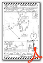
Standard Terminal Arrival (STAR) Charts
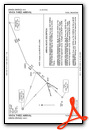
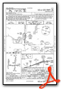
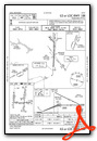
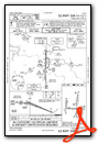
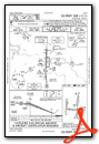
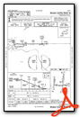
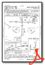
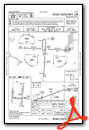
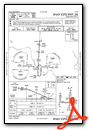
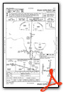
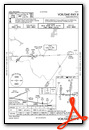
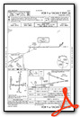
Instrument Approach Procedure (IAP) Charts
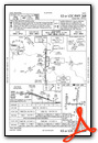

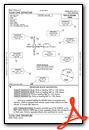
Departure Procedure (DP) Charts
Nearby Airports with Instrument Procedures
| ID | Name | Heading / Distance | ||
|---|---|---|---|---|
 |
KRVS | Tulsa Riverside Airport | 206° | 10.6 |
|
KOWP | William R Pogue Municipal Airport | 263° | 12.9 |
|
KGCM | Claremore Regional Airport | 073° | 20.6 |
|
H71 | Mid-America Industrial Airport | 086° | 27.1 |
|
H68 | Hefner-Easley Airport | 117° | 30.0 |
|
KOKM | Okmulgee Regional/Paul and Betty Abbott Field Airport | 185° | 31.9 |
|
KBVO | Bartlesville Municipal Airport | 350° | 34.4 |
|
3F7 | Jones Memorial Airport | 228° | 35.0 |
|
KMKO | Muskogee-Davis Regional Airport | 141° | 41.3 |
|
H04 | Vinita Municipal Airport | 054° | 43.5 |
|
KCUH | Cushing Municipal Airport | 251° | 45.6 |
|
KTQH | Tahlequah Municipal Airport | 110° | 45.9 |
Fuel Providers

Airport Images
Do you have a recent image of this airport? Upload it here!


