Login
Register


WLD
Strother Field Airport
Official FAA Data Effective 2026-01-22 0901Z
Chart Supplement

VFR Chart of KWLD
Sectional Charts at SkyVector.com
IFR Chart of KWLD
Enroute Charts at SkyVector.com
Location Information for KWLD
Coordinates: N37°10.12' / W97°2.25'Located 05 miles SW of Winfield/Arkansas City, Kansas on 1656 acres of land. View all Airports in Kansas.
Surveyed Elevation is 1160 feet MSL.
Operations Data
|
|
Airport Communications
| ASOS: | 118.025 Tel. 620-221-9121 |
|---|---|
| CTAF: | 122.800 |
| UNICOM: | 122.800 |
| AWOS-3P at EGT (19.3 NW): | 118.875 620-359-2156 |
| ASOS at PNC (26.4 S): | 134.075 580-765-0049 |
| D-ATIS at IAB (29.4 N): | 269.9 |
- APCH/DEP CTL SVC PRVDD BY KANSAS CITY ARTCC (ZKC) ON FREQS 127.8/319.1 (PONCA CITY RCAG).
Nearby Navigation Aids
|
| ||||||||||||||||||||||||||||||||||||||||||||||||||||||||||||


Runway 17/35
| Dimensions: | 5506 x 100 feet / 1678 x 30 meters | |
|---|---|---|
| Surface: | Asphalt in Good Condition | |
| Weight Limits: | 16 /F/D/X/T, S-45, D-60 | |
| Edge Lighting: | High Intensity | |
| Runway 17 | Runway 35 | |
| Coordinates: | N37°10.64' / W97°2.17' | N37°9.73' / W97°2.17' |
| Elevation: | 1158.1 | 1149.5 |
| Traffic Pattern: | Left | Left |
| Runway Heading: | 180° True | 360° True |
| Markings: | Non-Precision Instrument in good condition. | Non-Precision Instrument in good condition. |
| Glide Slope Indicator | P4L (3.00° Glide Path Angle) | P4L (3.00° Glide Path Angle) |
| REIL: | Yes | Yes |
| Obstacles: | 56 ft Trees 1678 ft from runway, 370 ft left of center | |
Runway 13/31
| Dimensions: | 3137 x 75 feet / 956 x 23 meters | |
|---|---|---|
| Surface: | Asphalt in Good Condition | |
| Weight Limits: | S-28, D-48 | |
| Edge Lighting: | Medium Intensity | |
| Runway 13 | Runway 31 | |
| Coordinates: | N37°10.20' / W97°2.61' | N37°9.80' / W97°2.19' |
| Elevation: | 1160.3 | 1151.6 |
| Traffic Pattern: | Left | Left |
| Runway Heading: | 140° True | 320° True |
| Markings: | Basic in good condition. | Basic in good condition. |
Services Available
| Fuel: | 100LL (blue), Jet-A |
|---|---|
| Transient Storage: | Hangars,Tiedowns |
| Airframe Repair: | NOT AVAILABLE |
| Engine Repair: | NOT AVAILABLE |
| Bottled Oxygen: | NONE |
| Bulk Oxygen: | NOT AVAILABLE |
| Other Services: | AIR FREIGHT SERVICES,CHARTER SERVICE |
Ownership Information
| Ownership: | Publicly owned | |
|---|---|---|
| Owner: | CITIES OF WINFIELD & ARKANSAS | |
| PO BOX 747 | ||
| WINFIELD, KS 67156 | ||
| 620-221-9280 | ||
| Manager: | SHAWN MCGREW | |
| 22193 TUPPER ST | ||
| WINFIELD, KS 67156 | ||
| 620-221-9280 | AFTER HOURS PHONE 620-221-9280 . | |
Other Remarks
- PILOT LOUNGE KEY CODE 1228
- 0LL FUEL 24 HR SELF SERV..
- ACTVT MIRL RWY 13/31 & HIRL RWY 17/35; PAPI AND REIL RWYS 17 & 35 - CTAF.
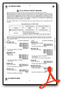
Weather Minimums

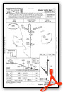
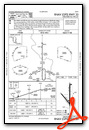
Instrument Approach Procedure (IAP) Charts
Nearby Airports with Instrument Procedures
| ID | Name | Heading / Distance | ||
|---|---|---|---|---|
 |
KEGT | Wellington Municipal Airport | 299° | 19.2 |
|
K50 | Cook Airfield Airport | 344° | 24.7 |
|
KPNC | Ponca City Regional Airport | 186° | 26.3 |
|
KIAB | Mc Connell AFB Airport | 338° | 29.4 |
|
KBKN | Blackwell-Tonkawa Municipal Airport | 210° | 29.5 |
|
3AU | Augusta Municipal Airport | 356° | 30.1 |
|
KCEA | Cessna Acft Field Airport | 340° | 30.5 |
|
KBEC | Beech Factory Airport | 344° | 32.6 |
|
KICT | Wichita Dwight D Eisenhower Ntl Airport | 326° | 34.5 |
|
KAAO | Colonel James Jabara Airport | 345° | 35.8 |
|
1K1 | Lloyd Stearman Field Airport | 354° | 36.5 |
|
KEQA | El Dorado/Capt Jack Thomas Memorial Airport | 016° | 37.8 |
Airport Images

By: TurningFinal


