Login
Register


06D
Rolla Municipal/Leonard Krech Field Airport
Official FAA Data Effective 2026-01-22 0901Z
Chart Supplement

VFR Chart of 06D
Sectional Charts at SkyVector.com
IFR Chart of 06D
Enroute Charts at SkyVector.com
Location Information for 06D
Coordinates: N48°53.07' / W99°37.26'Located 02 miles N of Rolla, North Dakota on 206 acres of land. View all Airports in North Dakota.
Surveyed Elevation is 1822 feet MSL.
Operations Data
|
|
Airport Communications
| AWOS-3: | 118.125 Tel. 701-477-0055 |
|---|---|
| UNICOM: | 122.800 |
| CTAF: | 122.800 |
| AWOS-3 at 9D7 (28.7 SE): | 118.325 701-968-3625 |
| AWOS-3PT at D09 (31.6 W): | 118.25 701-228-2688 |
| AWOS-3 at RUG (33.7 SW): | 118.475 701-776-6100 |
- APCH/DEP SVC PRVDD BY MINNEAPOLIS ARTCC ON FREQS 127.6/279.6 (MINOT RCAG).
- COMMUNICATIONS PRVDD BY GRAND FORKS RADIO ON FREQ 122.4 (ROLLA RCO).
Nearby Navigation Aids
|
| ||||||||||||||||||||||||||||||||||||


Runway 14/32
| Dimensions: | 4300 x 75 feet / 1311 x 23 meters | |
|---|---|---|
| Surface: | Asphalt in Fair Condition | |
| Weight Limits: | S-12 | |
| Edge Lighting: | Medium Intensity | |
| Runway 14 | Runway 32 | |
| Coordinates: | N48°53.39' / W99°37.55' | N48°52.78' / W99°37.02' |
| Elevation: | 1822.6 | 1816.5 |
| Traffic Pattern: | Left | Left |
| Runway Heading: | 150° True | 330° True |
| Markings: | Non-Precision Instrument in fair condition. | Non-Precision Instrument in fair condition. |
| Glide Slope Indicator | P2L (3.00° Glide Path Angle) | P2L (3.00° Glide Path Angle) |
Runway 07/25
| Dimensions: | 2200 x 75 feet / 671 x 23 meters | |
|---|---|---|
| Surface: | Turf in Good Condition | |
| Runway 07 | Runway 25 | |
| Coordinates: | N48°53.00' / W99°37.47' | N48°53.05' / W99°36.93' |
| Elevation: | 1820.8 | 1811.9 |
| Traffic Pattern: | Left | Left |
| Runway Heading: | 82° True | 262° True |
Services Available
| Fuel: | 100LL (blue), Jet-A |
|---|---|
| Transient Storage: | Hangars,Tiedowns |
| Airframe Repair: | NONE |
| Engine Repair: | NONE |
| Bottled Oxygen: | NONE |
| Bulk Oxygen: | NONE |
| Other Services: | CROP DUSTING SERVICES |
Ownership Information
| Ownership: | Publicly owned | |
|---|---|---|
| Owner: | ROLLA AIRPORT AUTHORITY | |
| 10125 COUNTY RD 23 | ||
| ROLLA, ND 58367 | ||
| 701-550-9884 | ||
| Manager: | GORDON KRECH | |
| 1104 6TH ST NE | ||
| ROLLA, ND 58367 | ||
| 701-550-9884 | ADDNL PHONE CELL PHONE 701-550-0134 OR AL KRECH 701-550-9885. | |
Other Remarks
- FOR SNOW REMOVAL & ARPT CONDS CALL AMGR 701-550-9884, 701-550-0134 OR 701-550-9885.
- RY 07/25 CLSD WINTER MONTHS (OCT-APR) DUE TO LACK OF SNOW REMOVAL.
- WATERFOWL & BIRDS ON & INVOF AIRPORT.
- FOR AWOS CALL 701-477-0055.
- FOR CD IF UNA TO CTC ON FSS FREQ, CTC MINNEAPOLIS ARTCC AT 651-463-5588.
- 0LL 24 HOUR SELF SERVICE CREDIT CARD FUEL AVBL.
- ACTVT MIRL RY 14/32 & PAPI RYS 14 & 32 - CTAF.
Weather Minimums


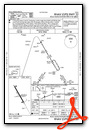
Instrument Approach Procedure (IAP) Charts
Nearby Airports with Instrument Procedures
| ID | Name | Heading / Distance | ||
|---|---|---|---|---|
 |
9D7 | Cando Municipal Airport | 147° | 28.7 |
|
D09 | Bottineau Municipal Airport | 264° | 31.7 |
|
KRUG | Rugby Municipal Airport | 208° | 33.7 |
|
D55 | Robertson Field Airport | 098° | 49.3 |
|
KDVL | Devils Lake Regional Airport | 148° | 54.1 |
|
5H4 | Harvey Municipal Airport | 190° | 66.8 |
|
96D | Walhalla Municipal Airport | 086° | 68.1 |
|
5L0 | Lakota Municipal Airport | 134° | 72.9 |
|
KMIB | Minot AFB Airport | 248° | 74.6 |
|
KMOT | Minot International Airport | 240° | 76.0 |
|
KHBC | Mohall Municipal Airport | 265° | 76.3 |
|
2C8 | Cavalier Municipal Airport | 093° | 79.1 |
Airport Images
Do you have a recent image of this airport? Upload it here!


