Login
Register


DVL
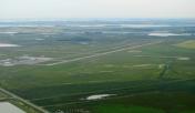
Devils Lake Regional Airport
Official FAA Data Effective 2026-01-22 0901Z
Chart Supplement

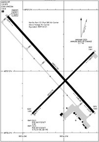
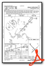
KDVL Airport Diagram
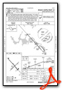
VFR Chart of KDVL
Sectional Charts at SkyVector.com
IFR Chart of KDVL
Enroute Charts at SkyVector.com
Location Information for KDVL
Coordinates: N48°7.00' / W98°54.60'Located 02 miles W of Devils Lake, North Dakota on 730 acres of land. View all Airports in North Dakota.
Surveyed Elevation is 1469 feet MSL.
Operations Data
|
|
Airport Communications
| AWOS-3PT: | 125.875 Tel. 701-662-7214 |
|---|---|
| CTAF: | 122.800 |
| UNICOM: | 122.800 |
| AWOS-3 at 9D7 (25.4 NW): | 118.325 701-968-3625 |
| AWOS-3 at 46D (41.1 S): | 118.575 701-652-1875 |
| AWOS-3 at D55 (43.4 NE): | 118.225 701-256-2121 |
- COMMUNICATIONS PRVDD BY GRAND FORKS RADIO ON FREQ 122.3 (DEVILS LAKE RCO).
- APCH/DEP SVC PRVDD BY MINNEAPOLIS ARTCC (ZMP) ON FREQ 124.2/270.3 (WOODWORTH RCAG).
Nearby Navigation Aids
|
| ||||||||||||||||||||||||||||||||||||||||||


Runway 13/31
| Dimensions: | 6400 x 100 feet / 1951 x 30 meters | |
|---|---|---|
| Surface: | Asphalt / Grooved in Good Condition | |
| Weight Limits: | S-75, D-130, ST-190
PCR VALUE: 337/F/D/X/T
| |
| Edge Lighting: | High Intensity | |
| Runway 13 | Runway 31 | |
| Coordinates: | N48°7.45' / W98°55.19' | N48°6.67' / W98°54.14' |
| Elevation: | 1469.4 | 1443.3 |
| Runway Heading: | 138° True | 318° True |
| Declared Distances: | TORA:6401 TODA:6401 ASDA:6401 LDA:6401 | TORA:6401 TODA:6401 ASDA:6401 LDA:6401 |
| Markings: | Non-Precision Instrument in good condition. | Precision Instrument in good condition. |
| Glide Slope Indicator | P4L (3.00° Glide Path Angle) | P4L (3.00° Glide Path Angle) |
| Approach Lights: | MALSR 1,400 Foot Medium-intensity Approach Lighting System with runway alignment indicator lights. | |
| REIL: | Yes | |
| Obstacles: | 29 ft Building 1400 ft from runway, 650 ft left of center | |
Runway 03/21
RWY 03/21 NOT AVBL FOR PART 121/PART 380 OPS WITH SKED PAX CARRYING OPS MORE THAN 9 PAX SEATS AND NON-SKED PAX CARRYING OPS MORE THAN 30 PAX SEATS. | ||
| Dimensions: | 4314 x 75 feet / 1315 x 23 meters | |
|---|---|---|
| Surface: | Asphalt in Good Condition | |
| Weight Limits: | S-30
PCR VALUE: 245/F/D/X/T
| |
| Edge Lighting: | Medium Intensity | |
| Runway 03 | Runway 21 | |
| Coordinates: | N48°6.65' / W98°54.88' | N48°7.16' / W98°54.13' |
| Elevation: | 1449.9 | 1441.0 |
| Traffic Pattern: | Left | Left |
| Runway Heading: | 45° True | 225° True |
| Declared Distances: | TORA:4314 TODA:4314 ASDA:4314 LDA:4314 | TORA:4314 TODA:4314 ASDA:4314 LDA:4314 |
| Markings: | Non-Precision Instrument in good condition. | Non-Precision Instrument in good condition. |
| Glide Slope Indicator | P2L (3.00° Glide Path Angle) | P2L (3.00° Glide Path Angle) |
| REIL: | Yes | Yes |
| Obstacles: | 35 ft Road 1119 ft from runway, 384 ft left of center | 38 ft Tree 1523 ft from runway, 131 ft right of center |
Services Available
| Fuel: | 100LL (blue), Jet-A |
|---|---|
| Transient Storage: | Hangars,Tiedowns |
| Airframe Repair: | MAJOR |
| Engine Repair: | MAJOR |
| Bottled Oxygen: | NONE |
| Bulk Oxygen: | NONE |
| Other Services: | AIR FREIGHT SERVICES,CROP DUSTING SERVICES,AIR AMBULANCE SERVICES,CHARTER SERVICE,PILOT INSTRUCTION,AIRCRAFT RENTAL,AIRCRAFT SALES,ANNUAL SURVEYING |
Ownership Information
| Ownership: | Publicly owned | |
|---|---|---|
| Owner: | DEVILS LAKE AIRPORT AUTHORITY | |
| 106 NATIONAL GUARD ST NW | ||
| DEVILS LAKE, ND 58301-8993 | ||
| 701-662-5833 | ||
| Manager: | DOMINIC ERITANO | |
| 106 NATIONAL GUARD ST NW | ||
| DEVILS LAKE, ND 58301-8993 | ||
| 701-662-5833 | ||
Other Remarks
- NUMEROUS WATERFOWL & OTHER BIRDS; DEER & JACK RABBITS ON & INVOF ARPT.
- FOR CD IF UNA TO CTC ON FSS FREQ, CTC MINNEAPOLIS ARTCC AT 651-463-5588.
- SKED AIR CARRIER OPNS INVOLVING ACFT WITH MORE THAN 9 PSGRS ARE NOT AUTH IN EXCESS OF 15 MINS BFR OR AFT SKED ARR/DEP TIMES WO PRIOR COORD WTH ARPT MGR TO ENSURE THAT ARFF IS AVBL.
- FUEL AVBL IREG HRS CALL 701-520-0229; SELF SVC AVGAS AVBL H24.
- ACTVT OR INCR INTST MALSR RWY 31; REIL RWY 03, 13, & 21; PAPI RWY 13/31; HIRL RWY 13/31, MIRL RWY 03/21 - CTAF.
Weather Minimums


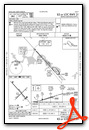
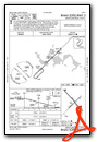
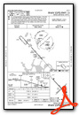
Instrument Approach Procedure (IAP) Charts
Nearby Airports with Instrument Procedures
| ID | Name | Heading / Distance | ||
|---|---|---|---|---|
 |
5L0 | Lakota Municipal Airport | 102° | 24.1 |
|
9D7 | Cando Municipal Airport | 329° | 25.4 |
|
46D | Carrington Municipal Airport | 193° | 41.1 |
|
D55 | Robertson Field Airport | 028° | 43.4 |
|
5H4 | Harvey Municipal Airport | 245° | 45.6 |
|
KRUG | Rugby Municipal Airport | 290° | 47.6 |
|
S32 | Cooperstown Municipal Airport | 141° | 52.9 |
|
06D | Rolla Municipal/Leonard Krech Field Airport | 328° | 54.1 |
|
4V4 | Northwood Municipal/Vince Field Airport | 113° | 58.2 |
|
KRDR | Grand Forks AFB Airport | 098° | 61.5 |
|
96D | Walhalla Municipal Airport | 038° | 63.7 |
|
KGAF | Hutson Field Airport | 073° | 64.1 |


Comments
DVL FBO
Their is a new FBO Jet A provider on the field with a 24/7 pilots lounge available.
Full Maintenance shop also
Devils Lake Aero Service
www.devilslakeaero.com
701-351-5382
Pages