Login
Register


0F4
Loup City Municipal Airport
Official FAA Data Effective 2026-01-22 0901Z
Chart Supplement

VFR Chart of 0F4
Sectional Charts at SkyVector.com
IFR Chart of 0F4
Enroute Charts at SkyVector.com
Location Information for 0F4
Coordinates: N41°17.18' / W98°59.40'Located 01 miles NW of Loup City, Nebraska on 284 acres of land. View all Airports in Nebraska.
Surveyed Elevation is 2072 feet MSL.
Operations Data
|
|
Airport Communications
| CTAF: | 122.900 |
|---|---|
| ASOS at ODX (20.3 N): | 119.925 308-728-7954 |
| ASOS at BBW (30.5 W): | 120.0 308-872-5354 |
| AWOS-3PT at EAR (33.6 S): | 123.875 308-237-5608 |
- APCH/DEP SVC PRVDD BY MINNEAPOLIS (ZMP) ARTCC ON FREQ 126.05 (GRAND ISLAND RCAG) / 278.8 (HASTINGS RCAG).
Nearby Navigation Aids
|
| ||||||||||||||||||||||||||||||||||||||||||||||||||||||


Runway 16/34
| Dimensions: | 3900 x 60 feet / 1189 x 18 meters | |
|---|---|---|
| Surface: | Concrete in Good Condition | |
| Weight Limits: | S-12 | |
| Edge Lighting: | Medium Intensity | |
| Runway 16 | Runway 34 | |
| Coordinates: | N41°17.49' / W98°59.48' | N41°16.87' / W98°59.28' |
| Elevation: | 2072.6 | 2067.6 |
| Traffic Pattern: | Left | Left |
| Runway Heading: | 166° True | 346° True |
| Markings: | Non-Precision Instrument in good condition. | Non-Precision Instrument in good condition. |
| Glide Slope Indicator | P2L (3.00° Glide Path Angle) | P2L (3.00° Glide Path Angle) |
Runway 04/22
| Dimensions: | 2021 x 100 feet / 616 x 30 meters | |
|---|---|---|
| Surface: | Turf in Fair Condition | |
| Runway 04 | Runway 22 | |
| Coordinates: | N41°17.08' / W98°59.61' | N41°17.30' / W98°59.27' |
| Elevation: | 2067.7 | 2069.5 |
| Traffic Pattern: | Left | Left |
| Runway Heading: | 50° True | 230° True |
| Obstacles: | 56 ft Trees 981 ft from runway, 178 ft right of center | 32 ft Tree 475 ft from runway, 101 ft left of center |
Services Available
| Fuel: | 100LL (blue) |
|---|---|
| Transient Storage: | Hangars,Tiedowns CALL AHD FOR TNST HNGR SPACE AMGR. |
| Airframe Repair: | NONE |
| Engine Repair: | NONE |
| Bottled Oxygen: | NONE |
| Bulk Oxygen: | NONE |
| Other Services: | CROP DUSTING SERVICES |
Ownership Information
| Ownership: | Publicly owned | |
|---|---|---|
| Owner: | LOUP CITY AIRPORT AUTHORITY | |
| PO BOX 29 | ||
| LOUP CITY, NE 68853-0029 | ||
| 308-390-1500 | ||
| Manager: | MIKE KING | |
| PO BOX 29 | ||
| LOUP CITY, NE 68853-0029 | ||
| 308-390-1500 | ||
Other Remarks
- FOR CD CTC MINNEAPOLIS ARTCC AT 651-463-5588.
- 0LL FUEL AVBL H24 VIA CREDIT CARD.
- MIRL RWY 16/34 LOW INTST SS-SR; TO INCREASE - CTAF. PAPI RWY 16 & 34 - CTAF
Weather Minimums

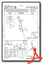
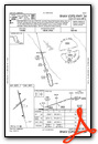
Instrument Approach Procedure (IAP) Charts
Nearby Airports with Instrument Procedures
| ID | Name | Heading / Distance | ||
|---|---|---|---|---|
 |
KODX | Evelyn Sharp Field Airport | 004° | 20.3 |
|
KBUB | Cram Field Airport | 346° | 30.3 |
|
KBBW | Broken Bow Municipal/Keith Glaze Field Airport | 287° | 30.8 |
|
KEAR | Kearney Regional Airport | 181° | 33.5 |
|
KGRI | Central Nebraska Regional Airport | 121° | 36.3 |
|
07K | Central City Municipal/Larry Reineke Field Airport | 103° | 43.8 |
|
0V3 | Pioneer Village Field Airport | 177° | 46.3 |
|
KLXN | Jim Kelly Field Airport | 230° | 46.4 |
|
KHSI | Hastings Municipal Airport | 147° | 48.2 |
|
KBVN | Albion Municipal Airport | 057° | 49.8 |
|
KAUH | Aurora Municipal/Al Potter Field Airport | 117° | 50.9 |
|
KCZD | Cozad Municipal Airport | 241° | 52.4 |
Airport Images
Do you have a recent image of this airport? Upload it here!


