Login
Register


LXN
Jim Kelly Field Airport
Official FAA Data Effective 2026-01-22 0901Z
Chart Supplement

VFR Chart of KLXN
Sectional Charts at SkyVector.com
IFR Chart of KLXN
Enroute Charts at SkyVector.com
Location Information for KLXN
Coordinates: N40°47.43' / W99°46.55'Located 02 miles NW of Lexington, Nebraska on 275 acres of land. View all Airports in Nebraska.
Surveyed Elevation is 2412 feet MSL.
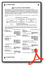
Operations Data
|
|
Airport Communications
| AWOS-3: | 121.025 Tel. 308-324-5975 |
|---|---|
| UNICOM: | 123.000 |
| CTAF: | 123.000 |
| AWOS-3 at HDE (28.6 SE): | 121.325 308-995-6433 |
| AWOS-3PT at CSB (33.9 SW): | 118.375 308-697-4279 |
| AWOS-3PT at EAR (35.2 E): | 123.875 308-237-5608 |
- APCH/DEP CTL SVC PRVDD BY DENVER ARTCC (ZDV) ON FREQS 132.7/226.675 (GRAND ISLAND WEST RCAG).
Nearby Navigation Aids
|
| ||||||||||||||||||||||||||||||||||||||||||||||||||||||


Runway 14/32
| Dimensions: | 5489 x 100 feet / 1673 x 30 meters | |
|---|---|---|
| Surface: | Concrete in Good Condition | |
| Weight Limits: | S-30 | |
| Edge Lighting: | Medium Intensity | |
| Runway 14 | Runway 32 | |
| Coordinates: | N40°47.82' / W99°46.99' | N40°47.10' / W99°46.28' |
| Elevation: | 2412.6 | 2403.3 |
| Traffic Pattern: | Left | Left |
| Runway Heading: | 143° True | 323° True |
| Markings: | Non-Precision Instrument in good condition. | Non-Precision Instrument in good condition. |
| Glide Slope Indicator | P2L (3.00° Glide Path Angle) | P2L (3.00° Glide Path Angle) |
| REIL: | Yes | Yes |
Runway 01/19
| Dimensions: | 3200 x 250 feet / 975 x 76 meters | |
|---|---|---|
| Surface: | Turf in Fair Condition | |
| Runway 01 | Runway 19 | |
| Coordinates: | N40°47.12' / W99°46.52' | N40°47.62' / W99°46.31' |
| Elevation: | 2400.0 | 2406.0 |
| Traffic Pattern: | Left | Left |
| Runway Heading: | 18° True | 198° True |
Services Available
| Fuel: | 100LL (blue), Jet A+ |
|---|---|
| Transient Storage: | Hangars,Tiedowns |
| Airframe Repair: | MAJOR |
| Engine Repair: | MAJOR |
| Bottled Oxygen: | NONE |
| Bulk Oxygen: | NONE |
| Other Services: | CROP DUSTING SERVICES |
Ownership Information
| Ownership: | Publicly owned | |
|---|---|---|
| Owner: | LEXINGTON AIRPORT AUTHORITY | |
| P.O. BOX 972 | ||
| LEXINGTON, NE 68850-0972 | ||
| 308-324-8770 | ||
| Manager: | NATHAN MASTEN | |
| 1501 NORTH AIRPORT ROAD | ||
| LEXINGTON, NE 68850-3471 | ||
| 308-324-8770 | ||
Other Remarks
- RY 01/19 NOT PLOWED WINTER MONTHS.
- FOR CD CTC DENVER ARTCC AT 303-651-4257.
- SELF SVC FUEL AVBL 24 HRS WITH CREDIT CARD.
- ACTVT REIL RY 14/32; MIRL RY 14/32; PAPI RYS 14/32 - CTAF.
Weather Minimums

Instrument Approach Procedure (IAP) Charts
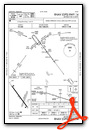

Nearby Airports with Instrument Procedures
| ID | Name | Heading / Distance | ||
|---|---|---|---|---|
 |
KCZD | Cozad Municipal Airport | 294° | 11.4 |
|
KGTE | Gothenburg Municipal Airport | 295° | 18.7 |
|
KHDE | Brewster Field Airport | 135° | 28.6 |
|
47V | Curtis Municipal Airport | 254° | 33.1 |
|
KCSB | Cambridge Municipal Airport | 211° | 34.0 |
|
KEAR | Kearney Regional Airport | 095° | 35.3 |
|
KBBW | Broken Bow Municipal/Keith Glaze Field Airport | 008° | 39.2 |
|
0V3 | Pioneer Village Field Airport | 113° | 41.4 |
|
4D9 | Alma Municipal Airport | 154° | 45.2 |
|
KLBF | North Platte Regional/Lee Bird Field Airport | 296° | 45.9 |
|
0F4 | Loup City Municipal Airport | 049° | 46.4 |
|
KMCK | Mc Cook Ben Nelson Regional Airport | 227° | 51.2 |
Airport Images

By: 2flaps

By: 2flaps


