Login
Register


15M
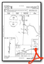
Segars Field Airport
Official FAA Data Effective 2025-12-25 0901Z
Chart Supplement

VFR Chart of 15M
Sectional Charts at SkyVector.com
IFR Chart of 15M
Enroute Charts at SkyVector.com
Location Information for 15M
Coordinates: N34°46.40' / W88°9.96'Located 03 miles SE of Iuka, Mississippi on 57 acres of land. View all Airports in Mississippi.
Surveyed Elevation is 625 feet MSL.
Operations Data
|
|
Airport Communications
| AWOS-3PT: | 119.250 Tel. 662-424-8004 |
|---|---|
| CTAF: | 122.900 |
| AWOS-3PT at CRX (23.5 NW): | 118.675 662-287-5103 |
| AWOS-3 at SNH (24.1 N): | 133.925 731-925-6080 |
| ASOS at MSL (27.5 E): | 119.425 256-383-2304 |
- APCH/DEP SVC PRVDD BY MEMPHIS ARTCC (ZME) ON FREQS 124.35/318.1 (MCKELLAR RCAG).
Nearby Navigation Aids
|
| ||||||||||||||||||||||||||||||||||||||||||||||||||||||


Runway 01/19
| Dimensions: | 4001 x 75 feet / 1220 x 23 meters | |
|---|---|---|
| Surface: | Asphalt / Grooved in Fair Condition | |
| Weight Limits: | S-30 | |
| Edge Lighting: | Medium Intensity | |
| Runway 01 | Runway 19 | |
| Coordinates: | N34°46.07' / W88°9.99' | N34°46.73' / W88°9.94' |
| Elevation: | 619.9 | 625.9 |
| Runway Heading: | 4° True | 184° True |
| Markings: | Non-Precision Instrument in fair condition. | Non-Precision Instrument in fair condition. |
| Glide Slope Indicator | P4L (3.00° Glide Path Angle) | P4L (4.00° Glide Path Angle) |
| Obstacles: | 47 ft Trees 1400 ft from runway | 39 ft Trees 1340 ft from runway, 200 ft right of center |
Services Available
| Fuel: | 100LL (blue) |
|---|---|
| Transient Storage: | Tiedowns PILOTS MUST PRVD THEIR OWN TIE-DOWN ROPES. |
| Airframe Repair: | NOT AVAILABLE |
| Engine Repair: | NOT AVAILABLE |
| Bottled Oxygen: | NONE |
| Bulk Oxygen: | NONE |
| Other Services: | CROP DUSTING SERVICES |
Ownership Information
| Ownership: | Publicly owned | |
|---|---|---|
| Owner: | TISHOMINGO DIST 1 2 & 3 | |
| PO BOX 1008 | ||
| IUKA, MS 38852 | ||
| 662-423-7032 | ||
| Manager: | RICK OWENS | |
| 1008 BATTLEGROUND DR | ||
| IUKA, MS 38852 | ||
| 662-424-2356 | ||
Other Remarks
- FOR CD CTC MEMPHIS ARTCC AT 901-368-8453/8449.
- +8 FT FENCE 200 FT FM THR 100 FT L.
- 0LL FUEL AVBL 24 HRS WITH CREDIT CARD.
- ACTVT PAPI RWY 01 & 19; MIRL RWY 01/19 - CTAF. RWY LGT INTST CAN BE CHGD M-H.
Weather Minimums
Instrument Approach Procedure (IAP) Charts

Nearby Airports with Instrument Procedures
| ID | Name | Heading / Distance | ||
|---|---|---|---|---|
 |
KCRX | Roscoe Turner Airport | 291° | 23.2 |
|
KSNH | Savannah-Hardin County Airport | 354° | 23.9 |
|
8M1 | Booneville/Baldwyn Airport | 245° | 26.2 |
|
KMSL | Northwest Alabama Regional Airport | 093° | 27.5 |
|
M22 | Bill Pugh Field Airport | 131° | 29.9 |
|
KSZY | Robert Sibley Airport | 327° | 30.5 |
|
KHAB | Marion County-Rankin Fite Airport | 167° | 40.2 |
|
1M4 | Posey Field Airport | 136° | 40.7 |
|
9A4 | Courtland Airport | 099° | 41.0 |
|
25M | Ripley Airport | 266° | 42.1 |
|
KTUP | Tupelo Regional Airport | 224° | 42.5 |
|
M72 | New Albany/Union County Airport | 252° | 44.6 |
Airport Images

By: wyoung


