Login
Register


MSL
Northwest Alabama Regional Airport
Official FAA Data Effective 2026-01-22 0901Z
Chart Supplement

VFR Chart of KMSL
Sectional Charts at SkyVector.com
IFR Chart of KMSL
Enroute Charts at SkyVector.com
Location Information for KMSL
Coordinates: N34°44.72' / W87°36.61'Located 01 miles E of Muscle Shoals, Alabama on 640 acres of land. View all Airports in Alabama.
Surveyed Elevation is 550 feet MSL.
Operations Data
|
|
Airport Communications
| ASOS: | 119.425 Tel. 256-383-2304 |
|---|---|
| CTAF: | 123.050 |
| UNICOM: | 123.050 |
| AWOS-3P at 9A4 (13.9 E): | 118.525 256-637-0903 |
| AWOS-3PT at 15M (27.6 W): | 119.250 662-424-8004 |
| AWOS-3PT at 1M4 (27.8 S): | 119.525 205-486-0035 |
- APCH/DEP SVC PRVDD BY MEMPHIS ARTCC ON FREQS 120.8/307.0 (HUNTSVILLE RCAG).
Nearby Navigation Aids
|
| ||||||||||||||||||||||||||||||||||||||||||||||||


Runway 12/30
| Dimensions: | 6694 x 150 feet / 2040 x 46 meters | |
|---|---|---|
| Surface: | Asphalt / Grooved in Good Condition | |
| Weight Limits: | S-59, D-98, ST-160
PCR VALUE: 430/F/B/X/T
| |
| Edge Lighting: | High Intensity | |
| Runway 12 | Runway 30 | |
| Coordinates: | N34°44.94' / W87°37.02' | N34°44.49' / W87°35.80' |
| Elevation: | 542.0 | 550.2 |
| Traffic Pattern: | Left | Left |
| Runway Heading: | 114° True | 294° True |
| Markings: | Precision Instrument in good condition. | Precision Instrument in good condition. |
| Glide Slope Indicator | P4R (3.00° Glide Path Angle) | |
| Approach Lights: | MALSR 1,400 Foot Medium-intensity Approach Lighting System with runway alignment indicator lights. | |
| REIL: | Yes | |
| Obstacles: | 52 ft Trees 1689 ft from runway, 269 ft right of center | 68 ft Trees 2004 ft from runway, 530 ft left of center |
Runway 18/36
RWY 18/36 NOT AVBL FOR PART 121/PART 380 OPS WITH SKED PAX CARRYING OPS MORE THAN 9 PAX SEATS AND NON-SKED PAX CARRYING OPS MORE THAN 30 PAX SEATS. | ||
| Dimensions: | 4000 x 100 feet / 1219 x 30 meters | |
|---|---|---|
| Surface: | Asphalt in Fair Condition | |
| Weight Limits: | S-30, D-50
PCR VALUE: 470/F/C/X/T
| |
| Edge Lighting: | Medium Intensity | |
| Runway 18 | Runway 36 | |
| Coordinates: | N34°45.05' / W87°36.94' | N34°44.40' / W87°36.96' |
| Elevation: | 539.3 | 540.9 |
| Traffic Pattern: | Left | Left |
| Runway Heading: | 181° True | 1° True |
| Markings: | Non-Precision Instrument in good condition. | Non-Precision Instrument in good condition. |
| Glide Slope Indicator | P4L (3.00° Glide Path Angle) | P4L (3.00° Glide Path Angle) |
| Obstacles: | 61 ft Tree 906 ft from runway, 283 ft left of center | |
Services Available
| Fuel: | 100LL (blue), Jet-A |
|---|---|
| Transient Storage: | Hangars,Tiedowns |
| Airframe Repair: | NONE |
| Engine Repair: | NONE |
| Bottled Oxygen: | NONE |
| Bulk Oxygen: | NONE |
| Other Services: | AIR FREIGHT SERVICES,PILOT INSTRUCTION,AIRCRAFT RENTAL |
Ownership Information
| Ownership: | Publicly owned | |
|---|---|---|
| Owner: | COLBERT & LAUDERDALE COUNTIES | |
| 1729 T. ED CAMPBELL DR SUITE A | ||
| MUSCLE SHOALS, AL 35661-2016 | ||
| 256-381-2869 | ||
| Manager: | BARRY GRIFFITH | |
| 1729 T. ED CAMPBELL DR SUITE A | ||
| MUSCLE SHOALS, AL 35661-2016 | ||
| 256-383-2270 | EXT. 101. | |
Other Remarks
- FOR CD IF UNA VIA GCO CTC MEMPHIS ARTCC AT 901-368-8453/8449.
- NO GA PARKING ON ACR RAMP.
- LNDG FEE & PAX FAC CHRG FOR UNSKED ACR & CHTR OPNS.
- TWY A IS THE PREF TWY FOR ACR & CHTR OPNS USING THE ACR RAMP.
- LNDG FEE FOR ACR OVER 12,500 LBS.
- GCO AVBL ON FREQ 121.725 FOR MEMPHIS ARTCC (ZME).
- CALM WIND RWY.
- 0LL FUEL AVBL NIGHTS CALL 256-383-2270. AVGAS 100LL SELF SERVE AVBL 24 HRS.
- ACTVT MALSR RWY 30; REIL RWY 12; PAPI RWY 12; PAPI RWY 18 & 36; HIRL RWY 12/30; MIRL RWY 18/36 - CTAF.
Weather Minimums

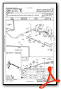
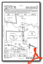
Instrument Approach Procedure (IAP) Charts
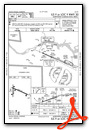
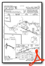

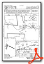
Nearby Airports with Instrument Procedures
| ID | Name | Heading / Distance | ||
|---|---|---|---|---|
 |
9A4 | Courtland Airport | 111° | 14.0 |
|
M22 | Bill Pugh Field Airport | 195° | 18.7 |
|
15M | Segars Field Airport | 273° | 27.5 |
|
1M4 | Posey Field Airport | 178° | 27.9 |
|
KDCU | Pryor Field Regional Airport | 099° | 33.3 |
|
2M2 | Lawrenceburg/Lawrence County (Fleeman Field) Airport | 030° | 34.1 |
|
KGZS | Abernathy Field Airport | 047° | 36.7 |
|
5M0 | Hartselle/Morgan County Regional Airport | 120° | 39.2 |
|
KSNH | Savannah-Hardin County Airport | 310° | 39.3 |
|
KHSV | Huntsville International-Carl T Jones Field Airport | 098° | 41.8 |
|
KHAB | Marion County-Rankin Fite Airport | 207° | 42.3 |
|
KCMD | Cullman Regional/Folsom Field Airport | 127° | 47.0 |
Airport Images
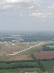
By: claytonsenyo


