Login
Register


TUP
Tupelo Regional Airport
Official FAA Data Effective 2026-01-22 0901Z
Chart Supplement

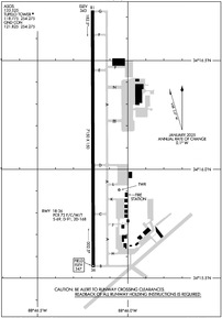
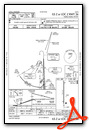
KTUP Airport Diagram
VFR Chart of KTUP
Sectional Charts at SkyVector.com
IFR Chart of KTUP
Enroute Charts at SkyVector.com
Location Information for KTUP
Coordinates: N34°16.14' / W88°46.19'Located 03 miles W of Tupelo, Mississippi on 1061 acres of land. View all Airports in Mississippi.
Surveyed Elevation is 346 feet MSL.
Operations Data
|
|
Airport Communications
| ASOS: | 133.525 Tel. 662-200-1505 |
|---|---|
| TUPELO TOWER: | 118.775 254.275 |
| TUPELO GROUND: | 121.825 254.275 |
| CTAF: | 118.775 |
| NG OPS: | 241.0 54.0FM |
| AWOS-3P at M40 (27.5 SE): | 118.475 662-369-3498 |
| AWOS-3PT at UOX (38.7 W): | 132.725 662-234-9751 |
| AWOS-3PT at CRX (40.0 N): | 118.675 662-287-5103 |
- APCH/DEP SVC PRVDD BY MEMPHIS ARTCC (TUPELO RCAG) ON FREQS 128.5/279.55.
- COMMUNICATIONS PRVDD BY GREENWOOD RADIO ON FREQ 122.5 (TUPELO RCO).
Nearby Navigation Aids
|
| ||||||||||||||||||||||||||||||||||||||||||||||||||||||||||||


Runway 18/36
| Dimensions: | 7150 x 150 feet / 2179 x 46 meters | |
|---|---|---|
| Surface: | Asphalt / Grooved in Excellent Condition | |
| Weight Limits: | S-69, D-91, ST-168
PCR VALUE: 72/F/C/W/T
| |
| Edge Lighting: | High Intensity | |
| Runway 18 | Runway 36 | |
| Coordinates: | N34°16.73' / W88°46.20' | N34°15.55' / W88°46.19' |
| Elevation: | 342.9 | 346.5 |
| Runway Heading: | 180° True | 360° True |
| Markings: | Non-Precision Instrument in good condition. | Precision Instrument in good condition. |
| Glide Slope Indicator | P4L (3.00° Glide Path Angle) | P4L (3.00° Glide Path Angle) |
| Approach Lights: | MALSR 1,400 Foot Medium-intensity Approach Lighting System with runway alignment indicator lights. | |
| REIL: | Yes | |
Services Available
| Fuel: | 100LL (blue), Jet-A, Jet A+, Jet A-1+ |
|---|---|
| Transient Storage: | Buoys,Hangars,Tiedowns T-HNGRS. |
| Airframe Repair: | MAJOR |
| Engine Repair: | MAJOR |
| Bottled Oxygen: | HIGH/LOW |
| Bulk Oxygen: | NONE |
| Other Services: | CROP DUSTING SERVICES,PILOT INSTRUCTION,AIRCRAFT RENTAL |
Ownership Information
| Ownership: | Publicly owned | |
|---|---|---|
| Owner: | TUPELO AIRPORT AUTHORITY | |
| 2704 W JACKSON ST | ||
| TUPELO, MS 38801 | ||
| 662-823-2375 | EXT 8. | |
| Manager: | BRANDON PANNELL | |
| 2704 W JACKSON ST | ||
| TUPELO, MS 38801 | ||
| 662-841-6570 | ||
Other Remarks
- CAUTION: HEL OPS ALL HRS 700 FT AGL E OF RWY 18/36 - CTC CTAF FOR ADZY.
- ACR RAMP RSTRD TO ACR OPS EXCP WITH PPR. CALL AMGR MON-FRI 0800-1700; 662-841-6570.
- ARNG: SUPPORT FAC OPR 1300-2200Z++ MON-FRI EXC HOL. LTD PRK AVBL. NO TSNT FUEL AVBL. DSN 293-3438, C662-891-4438.
- FUEL SVC AVBL 24 HRS WITH CREDIT CARD.
- ACTVT MALSR RWY 36; REIL RWY 18; HIRL 18/36 - CTAF. PAPI RWY 18 & 36 OPR CONSLY.
Weather Minimums
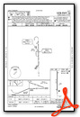
Instrument Approach Procedure (IAP) Charts


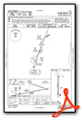
Nearby Airports with Instrument Procedures
| ID | Name | Heading / Distance | ||
|---|---|---|---|---|
 |
5A4 | Okolona Municipal/Richard Stovall Field Airport | 171° | 15.3 |
|
8M1 | Booneville/Baldwyn Airport | 017° | 20.3 |
|
M72 | New Albany/Union County Airport | 323° | 21.0 |
|
M40 | Monroe County Airport | 149° | 27.5 |
|
25M | Ripley Airport | 335° | 29.8 |
|
KUOX | University-Oxford Airport | 280° | 38.7 |
|
KHAB | Marion County-Rankin Fite Airport | 103° | 39.5 |
|
KCRX | Roscoe Turner Airport | 011° | 39.6 |
|
KCBM | Columbus AFB Airport | 156° | 40.7 |
|
M55 | Lamar County Airport | 127° | 41.3 |
|
M83 | Mccharen Field Airport | 172° | 41.3 |
|
15M | Segars Field Airport | 044° | 42.5 |
Airport Images
Do you have a recent image of this airport? Upload it here!


