Login
Register


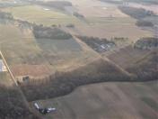
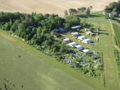
15N
Jenkins Airport
Official FAA Data Effective 2026-02-19 0901Z
Chart Supplement

VFR Chart of 15N
Sectional Charts at SkyVector.com
IFR Chart of 15N
Enroute Charts at SkyVector.com
Location Information for 15N
Coordinates: N39°7.04' / W75°35.07'Located 01 miles W of Wyoming, Delaware on 60 acres of land. View all Airports in Delaware.
Estimated Elevation is 53 feet MSL.
Operations Data
|
|
Airport Communications
| CTAF: | 122.800 |
|---|---|
| UNICOM: | 122.800 |
| D-ATIS at DOV (5.6 E): | 127.825 |
| AWOS-3 at 33N (6.1 N): | 120.125 302-571-6012 |
| AWOS-3 at EVY (25.0 N): | 132.325 302-378-2063 |
Nearby Navigation Aids
|
| ||||||||||||||||||||||||||||||||||||||||||||||||||||||||||||


Runway 12/30
| Dimensions: | 2035 x 70 feet / 620 x 21 meters | |
|---|---|---|
| Surface: | Turf in Good Condition | |
| Runway 12 | Runway 30 | |
| Coordinates: | N39°7.11' / W75°35.26' | N39°6.97' / W75°34.87' |
| Elevation: | 40.0 | 49.0 |
| Traffic Pattern: | Left | Left |
| Runway Heading: | 115° True | 295° True |
| Obstacles: | 97 ft Trees 255 ft from runway, 80 ft right of center | 64 ft Trees 100 ft from runway, 50 ft right of center |
Services Available
| Fuel: | NONE |
|---|---|
| Transient Storage: | Hangars |
| Airframe Repair: | MAJOR |
| Engine Repair: | MAJOR |
| Bottled Oxygen: | NONE |
| Bulk Oxygen: | NONE |
| Other Services: | AIRCRAFT SALES ACFT PARTS. |
Ownership Information
| Ownership: | Privately Owned | |
|---|---|---|
| Owner: | JOE C. JENKINS | |
| 9935 WESTVILLE RD | ||
| WYOMING, DE 19934 | ||
| 302-697-7743 | ||
| Manager: | JOE C. JENKINS | |
| 9935 WESTVILLE RD | ||
| WYOMING, DE 19934 | ||
| 302-697-7743 | ||
Other Remarks
- FOR CD CTC WASHINGTON ARTCC AT 703-771-3587.
- ORCHARDS EITHER SIDE OF RWY MAY ATTRACT BIRDS.
- ACTVT ROTG BCN - 122.8.
Nearby Airports with Instrument Procedures
| ID | Name | Heading / Distance | ||
|---|---|---|---|---|
 |
KDOV | Dover AFB Airport | 082° | 5.6 |
|
33N | Delaware Airpark Airport | 352° | 6.1 |
|
KRJD | Gooden Airpark Airport | 236° | 15.9 |
|
KEVY | Summit Airport | 345° | 25.1 |
|
KGED | Delaware Coastal Airport | 157° | 27.8 |
|
KMIV | Millville Municipal Airport | 057° | 28.2 |
|
KESN | Easton/Newnam Field Airport | 230° | 29.4 |
|
58M | Claremont Airport | 334° | 30.4 |
|
KWWD | Cape May County Airport | 101° | 32.3 |
|
KILG | New Castle Airport | 358° | 33.7 |
|
N06 | Laurel Airport | 180° | 34.5 |
|
W29 | Bay Bridge Airport | 256° | 35.9 |