Login
Register


1A3
Martin Campbell Field Airport
Official FAA Data Effective 2026-02-19 0901Z
Chart Supplement

VFR Chart of 1A3
Sectional Charts at SkyVector.com
IFR Chart of 1A3
Enroute Charts at SkyVector.com
Location Information for 1A3
Coordinates: N35°0.95' / W84°20.81'Located 03 miles NE of Copperhill, Tennessee on 59 acres of land. View all Airports in Tennessee.
Surveyed Elevation is 1789 feet MSL.
Operations Data
|
|
Airport Communications
| CTAF: | 122.900 |
|---|---|
| AWOS-3PT at DZJ (19.5 SE): | 119.325 706-745-9271 |
| AWOS-3 at 49A (24.8 S): | 118.075 706 276-4513 |
| AWOS-3 at RZR (25.1 NW): | 120.475 423-479-6823 |
- APCH/DEP SVC PRVDD BY ATLANTA ARTCC ON FREQS 133.1/342.425 (MOUNT OGLETHORPE RCAG).
Nearby Navigation Aids
|
| ||||||||||||||||||||||||||||||||||||||||||||||||||||||||||||


Runway 02/20
| Dimensions: | 3500 x 75 feet / 1067 x 23 meters | |
|---|---|---|
| Surface: | Asphalt in Good Condition | |
| Weight Limits: | S-30, D-45 | |
| Edge Lighting: | Non-Standard | |
| Runway 02 | Runway 20 | |
| Coordinates: | N35°0.67' / W84°20.89' | N35°1.23' / W84°20.73' |
| Elevation: | 1771.7 | 1788.7 |
| Traffic Pattern: | Left | Right |
| Runway Heading: | 14° True | 194° True |
| Displaced Threshold: | 90 Feet | 140 Feet |
| Declared Distances: | TORA:3500 TODA:3500 ASDA:3360 LDA:3270 | TORA:3270 TODA:3500 ASDA:3410 LDA:3270 |
| Markings: | Non-Precision Instrument in good condition. | Non-Precision Instrument in good condition. |
| Glide Slope Indicator | P2L (3.00° Glide Path Angle) | P2L (4.00° Glide Path Angle) |
Services Available
| Fuel: | 100LL (blue) |
|---|---|
| Transient Storage: | Hangars,Tiedowns |
| Airframe Repair: | MAJOR AIRFRAME RPR NEXT DOOR, ON CALL 706-490-4143 |
| Engine Repair: | MAJOR |
| Bottled Oxygen: | NOT AVAILABLE |
| Bulk Oxygen: | NOT AVAILABLE |
| Other Services: | PILOT INSTRUCTION |
Ownership Information
| Ownership: | Publicly owned | |
|---|---|---|
| Owner: | POLK COUNTY | |
| COUNTY COURTHOUSE | ||
| BENTON, TN 37307 | ||
| 423-338-4527 | ||
| Manager: | ALAN FROSCH | |
| 971 AIRPORT ROAD | ||
| COPPERHILL, TN 37317 | ||
| 423-496-9465 | ||
Other Remarks
- WILDLIFE INVOF RWY.
- FOR CD CTC ATLANTA ARTCC AT 770-210-7692.
- 0LL FUEL 24 HR CREDIT CARD SVC AVBL.
- ACTVT NON STANDARD LIRL RWY 02/20 - CTAF.
Weather Minimums

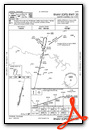
Instrument Approach Procedure (IAP) Charts

Nearby Airports with Instrument Procedures
| ID | Name | Heading / Distance | ||
|---|---|---|---|---|
 |
KDZJ | Blairsville Airport | 119° | 19.8 |
|
49A | Gilmer County Airport | 200° | 24.9 |
|
KRZR | Cleveland Regional Jetport Airport | 297° | 25.2 |
|
KMMI | Mcminn County Airport | 335° | 25.3 |
|
KRHP | Western Carolina Regional Airport | 065° | 26.1 |
|
KDNN | Dalton Municipal Airport | 235° | 31.2 |
|
KMNV | Monroe County Airport | 357° | 31.8 |
|
KJZP | Pickens County Airport | 189° | 34.1 |
|
2A0 | Mark Anton Airport | 314° | 40.2 |
|
KCHA | Lovell Field Airport | 271° | 42.2 |
|
KCNI | Cherokee County Regional Airport | 185° | 42.3 |
|
KCZL | Tom B David Field Airport | 221° | 44.6 |
Airport Images
")
By: 2flaps


