Login
Register


CNI
Cherokee County Regional Airport
Official FAA Data Effective 2026-01-22 0901Z
Chart Supplement

VFR Chart of KCNI
Sectional Charts at SkyVector.com
IFR Chart of KCNI
Enroute Charts at SkyVector.com
Location Information for KCNI
Coordinates: N34°18.73' / W84°25.33'Located 06 miles NE of Canton, Georgia on 160 acres of land. View all Airports in Georgia.
Surveyed Elevation is 1219 feet MSL.
Operations Data
|
|
Airport Communications
| AWOS-3PT: | 119.825 Tel. 678-454-2065 |
|---|---|
| ATLANTA APPROACH: | 121.0 268.7 |
| ATLANTA DEPARTURE: | 121.0 268.7 |
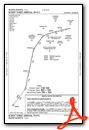
| BOKRT STAR: | 119.8 354.125 |
| CTAF: | 123.000 |
| WRGNZ STAR: | 128.575 343.675 |
| UNICOM: | 123.000 |
| AWOS-AV at JZP (8.7 N): | 120.025 706-253-9008 |
| AWOS-3 at 49A (19.8 N): | 118.075 706 276-4513 |
| ATIS at RYY (19.9 SW): | 128.125 |
Nearby Navigation Aids
|
| ||||||||||||||||||||||||||||||||||||||||||||||||||||||||||||


Runway 05/23
| Dimensions: | 5003 x 100 feet / 1525 x 30 meters | |
|---|---|---|
| Surface: | Asphalt in Good Condition | |
| Weight Limits: | S-26 | |
| Edge Lighting: | High Intensity | |
| Runway 05 | Runway 23 | |
| Coordinates: | N34°18.42' / W84°25.66' | N34°19.04' / W84°25.00' |
| Elevation: | 1206.1 | 1190.8 |
| Traffic Pattern: | Left | Left |
| Runway Heading: | 42° True | 222° True |
| Markings: | Non-Precision Instrument in good condition. | Non-Precision Instrument in good condition. |
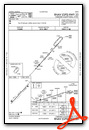
| Glide Slope Indicator | P4L (3.00° Glide Path Angle) | P4L (3.00° Glide Path Angle) |
| REIL: | Yes | Yes |
| Obstacles: | 13 ft Trees 326 ft from runway, 256 ft right of center | |
Services Available
| Fuel: | 100LL (blue), Jet A+ |
|---|---|
| Transient Storage: | Tiedowns |
| Airframe Repair: | MAJOR |
| Engine Repair: | MAJOR |
| Bottled Oxygen: | HIGH/LOW |
| Bulk Oxygen: | HIGH/LOW |
| Other Services: | CHARTER SERVICE,PILOT INSTRUCTION,AIRCRAFT RENTAL |
Ownership Information
| Ownership: | Publicly owned | |
|---|---|---|
| Owner: | CHEROKEE COUNTY AIRPORT AUTH. | |
| PO BOX 5052 | ||
| CANTON, GA 30114 | ||
| 678-454-2060 | ||
| Manager: | JIMMY GARLAND, FBO | |
| S&S AVIATION, 1350 BISHOP RD. | ||
| BALLGROUND, GA 30107 | ||
| 678-454-2090 | ||
Other Remarks
- FOR APCH/DEP SVC FOR ACFT ARRG AND DEPG FROM THE N CTC ATLANTA ARTCC AT 770-210-7692. FOR APCH/DEP SVC FOR ACFT ARRG AND DEPG FROM THE S CTC ATLANTA ARTCC AT 678-364-6131.
- FOR NOISE ABATEMENT RWY 23 PREF.
- RDO TRANSMISSIONS FROM THE DEP END OF RWY 23 MAY NOT BE RELBL DUE TO TRRN.
- ACTVT REIL RWY 05 & 23; PAPI RWY 05 & 23; HIRL RWY 05/23 - CTAF
Weather Minimums

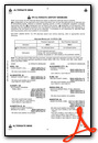
Standard Terminal Arrival (STAR) Charts
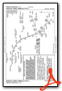
Instrument Approach Procedure (IAP) Charts

Nearby Airports with Instrument Procedures
| ID | Name | Heading / Distance | ||
|---|---|---|---|---|
 |
KJZP | Pickens County Airport | 348° | 8.6 |
|
49A | Gilmer County Airport | 344° | 19.6 |
|
KRYY | Cobb County International/Mccollum Field Airport | 205° | 19.9 |
|
KVPC | Cartersville Airport | 242° | 24.1 |
|
KMGE | Dobbins Arb Airport | 190° | 24.3 |
|
KPDK | Dekalb-Peachtree Airport | 167° | 26.8 |
|
KCZL | Tom B David Field Airport | 288° | 27.1 |
|
KGVL | Lee Gilmer Memorial Airport | 094° | 29.5 |
|
KLZU | Gwinnett County/Briscoe Field Airport | 131° | 30.4 |
|
KFTY | Fulton County Exec/Charlie Brown Field Airport | 188° | 32.2 |
|
KDNN | Dalton Municipal Airport | 318° | 33.1 |
|
KPUJ | Paulding Northwest Atlanta Airport | 227° | 35.2 |
Fuel Providers

Airport Images
Do you have a recent image of this airport? Upload it here!


