Login
Register


O47
Prague Municipal Airport
Official FAA Data Effective 2026-02-19 0901Z
Chart Supplement

VFR Chart of O47
Sectional Charts at SkyVector.com
IFR Chart of O47
Enroute Charts at SkyVector.com
Location Information for O47
Coordinates: N35°28.85' / W96°43.12'Located 02 miles W of Prague, Oklahoma on 90 acres of land. View all Airports in Oklahoma.
Surveyed Elevation is 1041 feet MSL.
Operations Data
|
|
Airport Communications
| CTAF: | 122.900 |
|---|---|
| AWOS-3 at SRE (12.6 S): | 118.625 405-382-0111 |
| AWOS-3PT at SNL (13.2 SW): | 118.275 405-214-1916 |
| AWOS-3PT at CQB (15.4 N): | 119.275 405-258-6724 |
- APCH/DEP CTL SVC PRVDD BY FORT WORTH ARTCC (ZFW) ON FREQS 132.2/338.35 (MC ALESTER RCAG).
Nearby Navigation Aids
|
| ||||||||||||||||||||||||||||||||||||||||||||||||||||||||||||


Runway 17/35
| Dimensions: | 3600 x 60 feet / 1097 x 18 meters | |
|---|---|---|
| Surface: | Asphalt in Good Condition | |
| Weight Limits: | S-4 | |
| Edge Lighting: | Medium Intensity | |
| Runway 17 | Runway 35 | |
| Coordinates: | N35°29.14' / W96°43.12' | N35°28.55' / W96°43.13' |
| Elevation: | 1041.0 | 1010.1 |
| Traffic Pattern: | Left | Left |
| Runway Heading: | 180° True | 0 |
| Displaced Threshold: | 110 Feet | |
| Markings: | Non-Precision Instrument in good condition. | Non-Precision Instrument in good condition. |
| Glide Slope Indicator | P2L (3.00° Glide Path Angle) | P2L (3.00° Glide Path Angle) |
| Obstacles: | 49 ft Tree 262 ft from runway, 205 ft right of center DTHR CREATES 8:1 CLNC SLOPE TO THLD. 36 FT PWR LN 225 FT LEFT OF RWY CNTRLN. 15 FT ROAD AT RWY END, 185 FT LEFT AND 150 FT RIGHT OF CNTRLN. |
36 FT PWR LN 225 FT LEFT OF RWY CNTRLN. 15 FT ROAD AT RWY END, 185 FT RIGHT OF CNTRLN. |
Services Available
| Fuel: | 100LL (blue) |
|---|---|
| Transient Storage: | Tiedowns |
| Airframe Repair: | MAJOR |
| Engine Repair: | MAJOR |
| Bottled Oxygen: | NONE |
| Bulk Oxygen: | NONE |
| Other Services: | PILOT INSTRUCTION |
Ownership Information
| Ownership: | Publicly owned | |
|---|---|---|
| Owner: | CITY OF PRAGUE | |
| 820 N JIM THORPE BLVD. | ||
| PRAGUE, OK 74864 | ||
| 405-567-2270 | ||
| Manager: | JIM GREFF | CITY MGR. |
| 820 N JIM THORPE BLVD. | ||
| PRAGUE, OK 74864 | ||
| 405-567-2270 | ||
Other Remarks
- FOR CD CTC FORT WORTH ARTCC AT 817-858-7584.
- 0LL AVBL 24 HRS CREDIT CARD ADPS.
- MIRL RWY 17/35 ON SS-SR, PRESET LOW INTST. INCR INTST - CTAF.
- FREQ OTS INDEFLY.
Weather Minimums

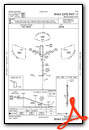
Instrument Approach Procedure (IAP) Charts

Nearby Airports with Instrument Procedures
| ID | Name | Heading / Distance | ||
|---|---|---|---|---|
 |
KSRE | Seminole Municipal Airport | 170° | 12.5 |
|
KSNL | Shawnee Regional Airport | 236° | 13.2 |
|
KCQB | Chandler Regional Airport | 341° | 15.4 |
|
3F7 | Jones Memorial Airport | 036° | 24.4 |
|
F99 | Holdenville Municipal Airport | 147° | 27.9 |
|
KCUH | Cushing Municipal Airport | 354° | 28.2 |
|
KTIK | Tinker AFB Airport | 263° | 33.0 |
|
F10 | Henryetta Municipal Airport | 097° | 34.7 |
|
KOKM | Okmulgee Regional/Paul and Betty Abbott Field Airport | 073° | 39.3 |
|
KOUN | University of Oklahoma Westheimer Airport | 249° | 39.6 |
|
KGOK | Guthrie/Edmond Regional Airport | 303° | 40.7 |
|
KADH | Ada Regional Airport | 176° | 40.6 |
Airport Images
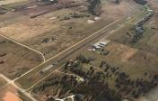
By: prague047


