Login
Register
1Q1
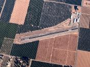
Eckert Field Airport
Official FAA Data Effective 2026-01-22 0901Z
VFR Chart of 1Q1
Sectional Charts at SkyVector.com
IFR Chart of 1Q1
Enroute Charts at SkyVector.com
Location Information for 1Q1
Coordinates: N36°9.74' / W119°3.04'Located 01 miles NE of Strathmore, California on 27 acres of land. View all Airports in California.
Estimated Elevation is 426 feet MSL.
Operations Data
|
|
Airport Communications
| CTAF: | 122.800 |
|---|---|
| UNICOM: | 122.800 |
| AWOS-3PT at PTV (8.1 S): | 134.625 559-784-3874 |
| AWOS-3PT at TLR (13.6 W): | 120.0 559-686-2613 |
| AWOS-3PT at VIS (18.7 NW): | 119.925 559-651-2418 |
Nearby Navigation Aids
|
| ||||||||||||||||||||||||||||||||||||||||||
Runway 13/31
| Dimensions: | 2000 x 50 feet / 610 x 15 meters | |
|---|---|---|
| Surface: | Asphalt in Good Condition | |
| Runway 13 | Runway 31 | |
| Coordinates: | N36°9.89' / W119°3.14' | N36°9.60' / W119°2.94' |
| Traffic Pattern: | Left | Left |
| Displaced Threshold: | 185 Feet | 265 Feet |
| Markings: | Basic in good condition. | Basic in good condition. |
| Obstacles: | 20 ft Trees 245 ft from runway, 130 ft left of center 21:1 OVER TREES TO DSPL THR +20' TREES 185'-225' FM THR 125'L-125'R. |
15 ft Trees 200 ft from runway RWY 31 APPROACH SLOPE 31:1 OVER TREES TO DSPL THR. APPROACH SLOPE 16:1 TO ROAD 253 FM DSPL THR ON CENTERLINE. +3 FT BUSHES AT THLD; +15 FT ROAD 0-125 FT FM THLD 125 FT L-125 FT R; +20 FT TREES 15-150 FT FM THLD 125 FT L-125 FT R. |
Services Available
| Fuel: | NONE |
|---|---|
| Transient Storage: | Tiedowns |
| Airframe Repair: | NONE |
| Engine Repair: | NONE |
| Bottled Oxygen: | NONE |
| Bulk Oxygen: | NONE |
| Other Services: | PILOT INSTRUCTION,GLIDER TOWING SERVICES |
Ownership Information
| Ownership: | Privately Owned | |
|---|---|---|
| Owner: | CURT SCHUTZE | |
| 116 BRYANT STREET | ||
| OJAI, CA 93023 | ||
| (805) 701-2184 | ||
| Manager: | CURT SCHUTZE | |
| 116 BRYANT STREET | ||
| OJAI, CA 93023 | ||
| (805) 701-2184 | ||
Other Remarks
- NIGHT OPNS PROHIBITED.
- FOR CD CTC OAKLAND ARTCC AT 510-745-3380.
- ARPT RAMP IS IN POOR COND WITH NMRS POTHOLES AND WIDE SECTION OF PAVEMENT UNRAVELING.
- RY 13 /31 BSC MARKINGS & EDGES MARKED WITH 4 INCH WHITE LINES.
Nearby Airports with Instrument Procedures
| ID | Name | Heading / Distance | ||
|---|---|---|---|---|
 |
KPTV | Porterville Municipal Airport | 184° | 8.0 |
 |
KTLR | Mefford Field Airport | 268° | 13.4 |
 |
KVIS | Visalia Municipal Airport | 299° | 19.1 |
 |
KDLO | Delano Municipal Airport | 199° | 26.6 |
 |
KHJO | Hanford Municipal Airport | 288° | 29.5 |
 |
O32 | Reedley Municipal Airport | 327° | 36.1 |
 |
KMIT | Shafter-Minter Field Airport | 190° | 39.8 |
 |
KBFL | Meadows Field Airport | 180° | 43.6 |
 |
KFAT | Fresno Yosemite International Airport | 318° | 49.0 |
 |
L45 | Bakersfield Municipal Airport | 176° | 50.2 |
 |
KFCH | Fresno Chandler Exec Airport | 312° | 50.5 |
 |
C80 | New Coalinga Municipal Airport | 270° | 60.4 |


