Login
Register


2DE2
Willaview Airport
Official FAA Data Effective 2026-01-22 0901Z
VFR Chart of 2DE2
Sectional Charts at SkyVector.com
IFR Chart of 2DE2
Enroute Charts at SkyVector.com
Location Information for 2DE2
Coordinates: N38°51.30' / W75°34.33'Located 01 miles SE of Farmington, Delaware. View all Airports in Delaware.
Elevation is 63 feet MSL.
Operations Data
|
|
Airport Communications
| ASOS at GED (14.0 SE): | 118.375 302-855-1052 |
|---|---|
| D-ATIS at DOV (17.2 N): | 127.825 |
| AWOS-3 at 33N (21.8 N): | 120.125 302-571-6012 |
Nearby Navigation Aids
|
| ||||||||||||||||||||||||||||||||||||||||||||||||||||||||||||


Runway 16/34
| Dimensions: | 2400 x 75 feet / 732 x 23 meters | |
|---|---|---|
| Surface: | Turf | |
| Runway 16 | Runway 34 | |
Ownership Information
| Ownership: | Privately Owned | |
|---|---|---|
| Owner: | DANIEL E. WILLIAMS III | |
| 21733 S. DUPONT HIGHWAY | ||
| GREENWOOD, DE 19950 | ||
| 302-382-1513 | ||
| Manager: | DANIEL E. WILLIAMS III | |
| 21733 S. DUPONT HIGHWAY | ||
| GREENWOOD, DE 19950 | ||
| 302-382-1513 | ||
Other Remarks
- FOR CD CTC WASHINGTON ARTCC AT 703-771-3587.
Nearby Airports with Instrument Procedures
| ID | Name | Heading / Distance | ||
|---|---|---|---|---|
 |
KGED | Delaware Coastal Airport | 135° | 14.2 |
|
KRJD | Gooden Airpark Airport | 296° | 15.4 |
|
KDOV | Dover AFB Airport | 016° | 17.2 |
|
N06 | Laurel Airport | 183° | 18.8 |
|
33N | Delaware Airpark Airport | 356° | 21.8 |
|
KESN | Easton/Newnam Field Airport | 262° | 23.5 |
|
KCGE | Cambridge-Dorchester Regional Airport | 228° | 28.7 |
|
KSBY | Salisbury-Ocean City Wicomico Regional Airport | 174° | 31.0 |
|
KWWD | Cape May County Airport | 073° | 32.4 |
|
W29 | Bay Bridge Airport | 281° | 36.2 |
|
KMIV | Millville Municipal Airport | 037° | 38.6 |
|
KOXB | Ocean City Municipal Airport | 146° | 38.9 |
Airport Images
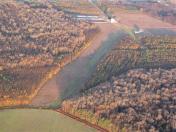
By: jlshoem
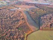
By: jlshoem


