Login
Register


OXB
Ocean City Municipal Airport
Official FAA Data Effective 2025-12-25 0901Z
Chart Supplement

VFR Chart of KOXB
Sectional Charts at SkyVector.com
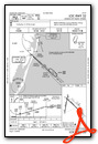
IFR Chart of KOXB
Enroute Charts at SkyVector.com
Location Information for KOXB
Coordinates: N38°18.63' / W75°7.44'Located 02 miles SW of Ocean City, Maryland on 578 acres of land. View all Airports in Maryland.
Surveyed Elevation is 15 feet MSL.
Operations Data
|
|
Airport Communications
| ASOS: | 119.025 Tel. 410-213-1530 |
|---|---|
| PATUXENT APPROACH: | 127.2 ;WHEN NHK APCH CLSD 281.475 ;WHEN NHK APCH CLSD 127.95 314.0 |
| PATUXENT DEPARTURE: | 127.2 ;WHEN NHK APCH CLSD 281.475 ;WHEN NHK APCH CLSD 127.95 314.0 |
| CLEARANCE DELIVERY: | 127.25 ;WHEN NHK APCH CLSD 121.75 |
| UNICOM: | 123.050 |
| CTAF: | 123.050 |
| ASOS at SBY (18.4 W): | 118.325 410-341-0868 |
| ASOS at GED (25.4 NW): | 118.375 302-855-1052 |
| ASOS at WAL (27.3 SW): | 119.175 757-824-0820 |
- APCH/DEP SVC PRVDD BY POTOMAC TRACON ON 127.2/281.475 WHEN PATUXENT APCH CTL CLSD.
Nearby Navigation Aids
|
| ||||||||||||||||||||||||||||||||||||||||||||||||||||||


Runway 14/32
| Dimensions: | 4074 x 75 feet / 1242 x 23 meters | |
|---|---|---|
| Surface: | Asphalt / Grooved in Good Condition | |
| Weight Limits: | S-45, D-75 | |
| Edge Lighting: | Medium Intensity | |
| Runway 14 | Runway 32 | |
| Coordinates: | N38°18.84' / W75°7.62' | N38°18.39' / W75°7.00' |
| Elevation: | 15.9 | 11.2 |
| Traffic Pattern: | Left | Left |
| Runway Heading: | 133° True | 313° True |
| Markings: | Non-Precision Instrument in good condition. | Non-Precision Instrument in good condition. |
| Glide Slope Indicator | P2L (4.00° Glide Path Angle) | P4L (3.00° Glide Path Angle) |
| REIL: | Yes | Yes |
| Obstacles: | 65 ft Trees 1329 ft from runway, 46 ft right of center 8 FT GRND/BRSH 180 FT 'R' OF RWY CNTRLN. |
|
Runway 02/20
| Dimensions: | 3204 x 75 feet / 977 x 23 meters | |
|---|---|---|
| Surface: | Asphalt in Good Condition | |
| Edge Lighting: | Medium Intensity | |
| Runway 02 | Runway 20 | |
| Coordinates: | N38°18.39' / W75°7.66' | N38°18.91' / W75°7.55' |
| Elevation: | 8.8 | 11.1 |
| Runway Heading: | 10° True | 190° True |
| Markings: | Non-Precision Instrument in good condition. | Non-Precision Instrument in good condition. |
| Glide Slope Indicator | P2L (3.00° Glide Path Angle) PAPI UNUSBL 6 DEG LEFT OF CNTRLN. | P2L (4.00° Glide Path Angle) |
| REIL: | Yes | Yes |
Services Available
| Fuel: | 100LL (blue), Jet-A |
|---|---|
| Transient Storage: | Hangars,Tiedowns HANGAR AVAILABILITY WITH PRIOR COORDINATION. |
| Airframe Repair: | MAJOR |
| Engine Repair: | MAJOR |
| Bottled Oxygen: | NONE |
| Bulk Oxygen: | NONE |
| Other Services: | CHARTER SERVICE,PILOT INSTRUCTION,PARACHUTE JUMP ACTIVITY,AIRCRAFT RENTAL,AIRCRAFT SALES,ANNUAL SURVEYING |
Ownership Information
| Ownership: | Publicly owned | |
|---|---|---|
| Owner: | MAYOR & CITY COUNCIL | |
| 301 N. BALTMORE AVE | ||
| OCEAN CITY, MD 21842 | ||
| 410-213-2471 | ||
| Manager: | JAIME GIANDOMENICO | |
| 12724 AIRPORT RD | ||
| BERLIN, MD 21811 | ||
| (443) 235-4434 | ||
Other Remarks
- DEER & BIRDS ON & INVOF ARPT.
- TRUCKS AND VEHICLES CROSSING TWY, NORTH OF HOLD BLOCK RWY 02.
- FOR CD CTC PATUXENT APCH AT 301-342-3740, WHEN PATUXENT APCH IS CLSD CTC POTOMAC APCH AT 866-640-4124.
- 0LL 24 HR SELF SERVE 100LL AVAILABLE WITH CREDIT CARD.
- ACTVT REIL RWY 14 & 32 - CTAF. REIL RWY 02 & 20; PAPI RWY 02, 14, 20, & 32; MIRL RWY 14/32 & RWY 02/20 OPR CONSLY.
Weather Minimums
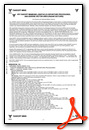

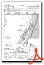
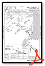
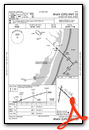
Instrument Approach Procedure (IAP) Charts
Nearby Airports with Instrument Procedures
| ID | Name | Heading / Distance | ||
|---|---|---|---|---|
 |
KSBY | Salisbury-Ocean City Wicomico Regional Airport | 275° | 18.3 |
|
KGED | Delaware Coastal Airport | 333° | 25.2 |
|
N06 | Laurel Airport | 302° | 26.2 |
|
KWAL | Wallops Flight Facility Airport | 216° | 27.5 |
|
W41 | Crisfield-Somerset County Airport | 242° | 37.6 |
|
KWWD | Cape May County Airport | 013° | 43.0 |
|
KCGE | Cambridge-Dorchester Regional Airport | 288° | 44.9 |
|
KMFV | Accomack County Airport | 217° | 49.9 |
|
KTGI | Tangier Island Airport | 235° | 50.6 |
|
KDOV | Dover AFB Airport | 341° | 51.7 |
|
KRJD | Gooden Airpark Airport | 318° | 52.7 |
|
KESN | Easton/Newnam Field Airport | 303° | 53.4 |


Comments
CTAF 123.05
CTAF has disappeared from all FAA publications for some reason. It is 123.05
Pages