
Login
Register


CGE
Cambridge-Dorchester Regional Airport
Official FAA Data Effective 2026-02-19 0901Z
Chart Supplement
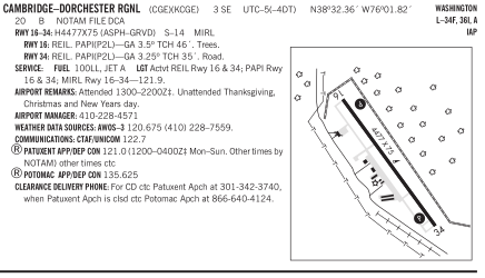
VFR Chart of KCGE
Sectional Charts at SkyVector.com
IFR Chart of KCGE
Enroute Charts at SkyVector.com
Location Information for KCGE
Coordinates: N38°32.36' / W76°1.82'Located 03 miles SE of Cambridge, Maryland on 354 acres of land. View all Airports in Maryland.
Surveyed Elevation is 19 feet MSL.
Operations Data
|
|
Airport Communications
| AWOS-3: | 120.675 Tel. 410-228-7559 |
|---|---|
| PATUXENT APPROACH: | 135.625 ;WHEN NHK APCH CLSD 269.625 ;WHEN NHK APCH CLSD 121.0 250.3 |
| PATUXENT DEPARTURE: | 135.625 ;WHEN NHK APCH CLSD 269.625 ;WHEN NHK APCH CLSD 121.0 250.3 |
| CTAF: | 122.700 |
| UNICOM: | 122.700 |
| ATIS at ESN (16.0 N): | 124.475 |
| AWOS-3PT at ESN (16.0 N): | 124.475 410-822-2817 |
| ATIS at NHK (23.4 SW): | 322.425 |
- APCH/DEP SVC PRVDD BY POTOMAC TRACON ON 135.625/269.625 WHEN PATUXENT APCH CTL CLSD.
Nearby Navigation Aids
|
| ||||||||||||||||||||||||||||||||||||||||||||||||||||||||||||


Runway 16/34
| Dimensions: | 4477 x 75 feet / 1365 x 23 meters | |
|---|---|---|
| Surface: | Asphalt / Grooved in Good Condition | |
| Weight Limits: | S-14 | |
| Edge Lighting: | Medium Intensity | |
| Runway 16 | Runway 34 | |
| Coordinates: | N38°32.66' / W76°2.10' | N38°32.06' / W76°1.55' |
| Elevation: | 18.5 | 15.7 |
| Traffic Pattern: | Left | Left |
| Runway Heading: | 144° True | 324° True |
| Markings: | Non-Precision Instrument in good condition. | Non-Precision Instrument in good condition. |
| Glide Slope Indicator | P2L (3.50° Glide Path Angle) | P2L (3.25° Glide Path Angle) |
| REIL: | Yes | Yes |
| Obstacles: | 60 ft Trees 1516 ft from runway, 240 ft left of center | 15 ft Road 440 ft from runway, 250 ft left of center |
Services Available
| Fuel: | 100LL (blue), Jet-A |
|---|---|
| Transient Storage: | Hangars,Tiedowns |
| Airframe Repair: | NONE |
| Engine Repair: | NONE |
| Bottled Oxygen: | NOT AVAILABLE |
| Bulk Oxygen: | NOT AVAILABLE |
| Other Services: | CROP DUSTING SERVICES,PILOT INSTRUCTION,AIRCRAFT RENTAL,AIRCRAFT SALES |
Ownership Information
| Ownership: | Publicly owned | |
|---|---|---|
| Owner: | DORCHESTER COUNTY CMSNRS | |
| 501 COURT LA | ||
| CAMBRIDGE, MD 21613 | ||
| 410-228-1700 | ||
| Manager: | STEVE NUWER | |
| 5263 BUCKTOWN RD | ||
| CAMBRIDGE, MD 21613 | ||
| 410-228-4571 | ||
Other Remarks
- THIS AIRPORT HAS BEEN SURVEYED BY THE NATIONAL GEODETIC SURVEY.
- BIRDS AND/OR WILDLIFE ON AND INVOF ARPT.
- FOR CD CTC PATUXENT APCH AT 301-342-3740, WHEN PATUXENT APCH IS CLSD CTC POTOMAC APCH AT 866-640-4124.
- ACTVT REIL RWY 16 & 34; PAPI RWY 16 & 34; MIRL RWY 16/34 - 121.9.
Weather Minimums

Instrument Approach Procedure (IAP) Charts


Nearby Airports with Instrument Procedures
| ID | Name | Heading / Distance | ||
|---|---|---|---|---|
 |
KESN | Easton/Newnam Field Airport | 353° | 16.0 |
|
N06 | Laurel Airport | 089° | 20.5 |
|
KNHK | Patuxent River NAS (Trapnell Field) Airport | 229° | 23.5 |
|
KRJD | Gooden Airpark Airport | 016° | 26.9 |
|
KSBY | Salisbury-Ocean City Wicomico Regional Airport | 115° | 27.3 |
|
2W6 | St Mary's County Regional Airport | 241° | 28.0 |
|
W29 | Bay Bridge Airport | 331° | 29.7 |
|
KGED | Delaware Coastal Airport | 074° | 32.8 |
|
W41 | Crisfield-Somerset County Airport | 162° | 32.7 |
|
KANP | Lee Airport | 313° | 35.0 |
|
W00 | Freeway Airport | 304° | 42.4 |
|
KADW | Joint Base Andrews Airport | 292° | 42.5 |



Comments
Kay's
Nobody has commented about the restaurant here? It's the BEST! People come by plane, boat, car from all over for good reason. Look em up on FB, or just fly in at lunch time!
Must visit airport and restaurant
I was there yesterday (1/14/2018). Very nice airport. Great parking and linemen. Very courteous and competent. It was cold (23 degrees) and windy but not the slightest complaint from the linemen about topping off my fuel. I agree with Ed, KAYS restaurant was wonderful. Great Maryland crab cakes and other items. I had the special which was a baked crab and shrimp dish and was surprised at how much crab meat was included. Delicious and fairly priced. Took some crap cakes back to NC for my wife who loved them. I will make it a point to stop by anytime I am in the area.
Pages