Login
Register


2I0
Madisonville Regional Airport
Official FAA Data Effective 2026-02-19 0901Z
Chart Supplement

VFR Chart of 2I0
Sectional Charts at SkyVector.com
IFR Chart of 2I0
Enroute Charts at SkyVector.com
Location Information for 2I0
Coordinates: N37°21.36' / W87°23.89'Located 05 miles NE of Madisonville, Kentucky on 215 acres of land. View all Airports in Kentucky.
Surveyed Elevation is 439 feet MSL.
Operations Data
|
|
Airport Communications
| AWOS-3: | 126.475 Tel. 270-821-4554 |
|---|---|
| EVANSVILLE APPROACH: | 124.025 290.9 |
| EVANSVILLE DEPARTURE: | 124.025 290.9 |
| CLEARANCE DELIVERY: | 120.1 |
| UNICOM: | 122.700 |
| CTAF: | 122.700 |
| AWOS-3 at M21 (13.9 SE): | 120.45 270-338-7788 |
| AWOS-3PT at OWB (25.5 NE): | 119.025 270-683-3228 |
| AWOS-3PT at JQD (26.7 E): | 132.1 270-298-7936 |
- APCH/DEP SVC PRVDD BY INDIANAPOLIS ARTCC ON FREQS 128.3/291.625 (EVANSVILLE RCAG) WHEN EVANSVILLE APCH CTL CLSD.
Nearby Navigation Aids
|
| ||||||||||||||||||||||||||||||||||||||||||||||||||||||||||||


Runway 05/23
| Dimensions: | 6051 x 100 feet / 1844 x 30 meters | |
|---|---|---|
| Surface: | Asphalt in Fair Condition | |
| Weight Limits: | 36 /F/C/X/T, S-92, D-127 | |
| Edge Lighting: | High Intensity | |
| Runway 05 | Runway 23 | |
| Coordinates: | N37°21.05' / W87°24.38' | N37°21.67' / W87°23.40' |
| Elevation: | 439.1 | 418.2 |
| Traffic Pattern: | Left | Left |
| Runway Heading: | 51° True | 231° True |
| Markings: | Non-Precision Instrument in fair condition. | Non-Precision Instrument in fair condition. |
| Glide Slope Indicator | P4R (3.00° Glide Path Angle) | P4L (3.00° Glide Path Angle) |
| Approach Lights: | ODALS Omnidirectional Approach Lighting System | |
| REIL: | Yes | |
| Obstacles: | 79 ft Trees 946 ft from runway, 434 ft left of center | |
Services Available
| Fuel: | 100LL (blue), Jet A+ |
|---|---|
| Transient Storage: | Hangars,Tiedowns |
| Airframe Repair: | NOT AVAILABLE |
| Engine Repair: | NOT AVAILABLE |
| Bottled Oxygen: | NOT AVAILABLE |
| Bulk Oxygen: | NOT AVAILABLE |
| Other Services: | PILOT INSTRUCTION,AIRCRAFT RENTAL |
Ownership Information
| Ownership: | Publicly owned | |
|---|---|---|
| Owner: | CITY OF MADISONVILLE | |
| CITY HALL | ||
| MADISONVILLE, KY 42431 | ||
| 270-824-2110 | ||
| Manager: | VICTORIA DAVENPORT | |
| 162 AIRPORT ROAD | ||
| MADISONVILLE, KY 42431 | ||
| 270-836-8111 | AFT HR - 270-871-5743. | |
Other Remarks
- FOR CD WHEN RCO 120.1 OTS CTC EVANSVILLE APCH AT 812-436-4689, WHEN APCH CLSD CTC INDIANAPOLIS ARTCC AT 317-247-2411.
- ACTVT ODALS RWY 23; REIL RWY 05; HIRL RWY 05/23 - CTAF. HIRL RWY 05/23 PRESET LOW INTST; INCR INTST - CTAF.
Weather Minimums

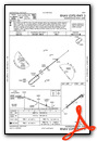
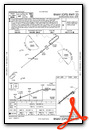
Instrument Approach Procedure (IAP) Charts
Nearby Airports with Instrument Procedures
| ID | Name | Heading / Distance | ||
|---|---|---|---|---|
 |
M21 | Muhlenberg County Airport | 123° | 13.9 |
|
KOWB | Owensboro/Daviess County Regional Airport | 025° | 25.5 |
|
2M0 | Princeton-Caldwell County Airport | 236° | 26.3 |
|
KJQD | Ohio County Airport | 076° | 26.9 |
|
KTWT | Sturgis Municipal Airport | 292° | 28.8 |
|
KHVC | Hopkinsville-Christian County Airport | 185° | 30.0 |
|
KEHR | Henderson City-County Airport | 333° | 30.4 |
|
KGDA | Marion-Crittenden County James C Johnson Regional Airport | 268° | 34.1 |
|
KHOP | Campbell AAF (Fort Campbell) Airport | 186° | 41.2 |
|
KEVV | Evansville Regional Airport | 351° | 41.5 |
|
4M7 | Russellville-Logan County Airport | 139° | 43.7 |
|
KCKV | Outlaw Field Airport | 181° | 44.0 |
Airport Images
Do you have a recent image of this airport? Upload it here!


