Login
Register


OWB
Owensboro/Daviess County Regional Airport
Official FAA Data Effective 2025-12-25 0901Z
Chart Supplement

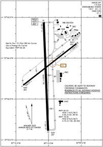
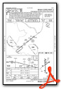
KOWB Airport Diagram
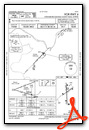
VFR Chart of KOWB
Sectional Charts at SkyVector.com
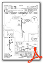
IFR Chart of KOWB
Enroute Charts at SkyVector.com
Location Information for KOWB
Coordinates: N37°44.33' / W87°10.01'Located 03 miles SW of Owensboro, Kentucky on 880 acres of land. View all Airports in Kentucky.
Surveyed Elevation is 407 feet MSL.
Operations Data
|
|
Airport Communications
| AWOS-3PT: | 119.025 Tel. 270-683-3228 |
|---|---|
| OWENSBORO TOWER: | 120.7 251.15 |
| OWENSBORO GROUND: | 121.7 |
| EVANSVILLE APPROACH: | 124.025 290.9 |
| EVANSVILLE DEPARTURE: | 124.025 290.9 |
| EMERG: | 121.5 243.0 |
| VFR ADZY: | 120.7 251.15 |
| CTAF: | 120.700 |
| UNICOM: | 122.950 |
| AWOS-3 at KY8 (19.4 NE): | 119.775 270-295-3565 |
| AWOS-3PT at JQD (22.6 SE): | 132.1 270-298-7936 |
| AWOS-3PT at EHR (24.8 W): | 118.85 270-826-0511 |
- APCH/DEP SVC PRVDD BY INDIANAPOLIS ARTCC ON FREQS 128.3/291.625 (EVANSVILLE RCAG) WHEN EVANSVILLE APCH CTL CLSD.
Nearby Navigation Aids
|
| ||||||||||||||||||||||||||||||||||||||||||||||||||||||||||||


Runway 18/36
| Dimensions: | 8000 x 150 feet / 2438 x 46 meters | |
|---|---|---|
| Surface: | Concrete / Grooved in Good Condition | |
| Weight Limits: | 37 /R/C/W/T, S-75, D-150, ST-200 | |
| Edge Lighting: | High Intensity | |
| Runway 18 | Runway 36 | |
| Coordinates: | N37°44.93' / W87°10.07' | N37°43.62' / W87°10.00' |
| Elevation: | 407.3 | 397.2 |
| Traffic Pattern: | Left | Left |
| Runway Heading: | 178° True | 358° True |
| Declared Distances: | TORA:8000 TODA:8000 ASDA:8000 LDA:8000 | TORA:8000 TODA:8000 ASDA:8000 LDA:8000 |
| Markings: | Precision Instrument in good condition. | Precision Instrument in good condition. |
| Glide Slope Indicator | P4L (3.00° Glide Path Angle) | P4L (3.00° Glide Path Angle) |
| Approach Lights: | MALSR 1,400 Foot Medium-intensity Approach Lighting System with runway alignment indicator lights. | |
| REIL: | Yes | |
Runway 06/24
RWY 06/24 NOT AVBL FOR PART 121/PART 380 OPS WITH SKED PAX CARRYING OPS MORE THAN 9 PAX SEATS AND NON-SKED PAX CARRYING OPS MORE THAN 30 PAX SEATS. | ||
| Dimensions: | 5000 x 100 feet / 1524 x 30 meters | |
|---|---|---|
| Surface: | Asphalt-Concrete in Fair Condition | |
| Weight Limits: | 17 /R/C/W/T, S-40, D-40, ST-40 | |
| Edge Lighting: | Medium Intensity | |
| Runway 06 | Runway 24 | |
| Coordinates: | N37°44.16' / W87°10.38' | N37°44.67' / W87°9.56' |
| Elevation: | 405.1 | 403.1 |
| Traffic Pattern: | Left | Left |
| Runway Heading: | 52° True | 232° True |
| Declared Distances: | TORA:5000 TODA:5000 ASDA:5000 LDA:5000 | TORA:5000 TODA:5000 ASDA:5000 LDA:5000 |
| Markings: | Non-Precision Instrument in good condition. | Non-Precision Instrument in good condition. |
| Glide Slope Indicator | P2L (3.00° Glide Path Angle) | P2L (3.00° Glide Path Angle) |
| REIL: | Yes | Yes |
Services Available
| Fuel: | 100LL (blue), Jet-A |
|---|---|
| Transient Storage: | Hangars,Tiedowns |
| Airframe Repair: | MAJOR |
| Engine Repair: | MAJOR |
| Bottled Oxygen: | LOW |
| Bulk Oxygen: | NOT AVAILABLE |
| Other Services: | AIR FREIGHT SERVICES,CHARTER SERVICE,PILOT INSTRUCTION |
Ownership Information
| Ownership: | Publicly owned | |
|---|---|---|
| Owner: | OWENSBORO CITY & DAVIESS COUNTY | |
| 2200 AIRPORT ROAD | ||
| OWENSBORO, KY 42303 | ||
| 270-685-4179 | ||
| Manager: | TRISTAN DURBIN | |
| 2200 AIRPORT ROAD | ||
| OWENSBORO, KY 42303 | ||
| 270-685-4179 | ||
Other Remarks
- WILDLIFE & AGRICULTURE OPS ON & INVOF ARPT.
- FOR CD WHEN ATCT CLSD CTC EVANSVILLE APCH AT 812-436-4690, WHEN APCH CLSD CTC INDIANAPOLIS ARTCC AT 317-247-2411.
- WHEN ATCT CLSD ACTVT MALSR RWY 36; REIL RWY 06, 18, 24; PAPI RWY 6, 18, 24, 36; MIRL RWY 6/24; HIRL RWY 18/36; TWY; WINDCONE - CTAF.
Weather Minimums
Instrument Approach Procedure (IAP) Charts


Nearby Airports with Instrument Procedures
| ID | Name | Heading / Distance | ||
|---|---|---|---|---|
 |
KY8 | Hancock County/Ron Lewis Field Airport | 048° | 19.6 |
|
KJQD | Ohio County Airport | 137° | 22.6 |
|
KEVV | Evansville Regional Airport | 316° | 25.0 |
|
KEHR | Henderson City-County Airport | 279° | 25.0 |
|
2I0 | Madisonville Regional Airport | 205° | 25.5 |
|
KTEL | Perry County Municipal Airport | 053° | 28.1 |
|
M21 | Muhlenberg County Airport | 179° | 30.7 |
|
KHNB | Huntingburg Airport | 018° | 32.2 |
|
I93 | Breckinridge County Airport | 085° | 34.6 |
|
KTWT | Sturgis Municipal Airport | 252° | 39.3 |
|
M20 | Leitchfield-Grayson County Airport | 114° | 47.7 |
|
2M0 | Princeton-Caldwell County Airport | 221° | 49.9 |
Airport Images
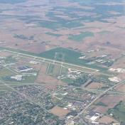
By: Big Orange Bird


