Login
Register


2P2
Washington Island Airport
Official FAA Data Effective 2025-12-25 0901Z
Chart Supplement

VFR Chart of 2P2
Sectional Charts at SkyVector.com
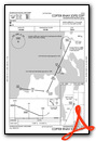
IFR Chart of 2P2
Enroute Charts at SkyVector.com
Location Information for 2P2
Coordinates: N45°23.30' / W86°55.44'Located 01 miles S of Washington Island, Wisconsin on 113 acres of land. View all Airports in Wisconsin.
Estimated Elevation is 652 feet MSL.
Operations Data
|
|
Airport Communications
| AWOS-3PT: | 118.525 Tel. 920 847 3024 |
|---|---|
| CTAF: | 122.900 |
| AWOS-3PT at 3D2 (18.9 SW): | 124.175 920-854-5559 |
| AWOS-3PT at ESC (21.3 N): | 121.425 906-786-9001 |
| AWOS-3PT at MNM (34.0 SW): | 121.45 906-863-8801 |
- APCH/DEP SVC PRVDD BY MINNEAPOLIS ARTCC ON FREQ 127.65 (ESCANABA RCAG).
Nearby Navigation Aids
|
| ||||||||||||||||||||||||||||||||||||||||||||||||||||||


Runway 02/20
| Dimensions: | 2250 x 150 feet / 686 x 46 meters | |
|---|---|---|
| Surface: | Turf in Good Condition | |
| Edge Lighting: | Low Intensity | |
| Runway 02 | Runway 20 | |
| Coordinates: | N45°23.07' / W86°55.52' | N45°23.41' / W86°55.30' |
| Elevation: | 650.4 | 643.1 |
| Runway Heading: | 25° True | 205° True |
| Obstacles: | 45 ft Trees 750 ft from runway, 200 ft right of center | 32 ft Trees 380 ft from runway, 140 ft left of center |
Runway 14/32
| Dimensions: | 2232 x 150 feet / 680 x 46 meters | |
|---|---|---|
| Surface: | Turf in Good Condition | |
| Edge Lighting: | Low Intensity | |
| Runway 14 | Runway 32 | |
| Coordinates: | N45°23.50' / W86°55.63' | N45°23.20' / W86°55.32' |
| Elevation: | 652.5 | 636.2 |
| Traffic Pattern: | Left | Left |
| Runway Heading: | 143° True | 323° True |
| Obstacles: | 66 ft Trees 690 ft from runway, 190 ft right of center | 61 ft Tree 590 ft from runway, 180 ft right of center |
Services Available
| Fuel: | NONE |
|---|---|
| Transient Storage: | Tiedowns |
| Airframe Repair: | NONE |
| Engine Repair: | NONE |
| Bottled Oxygen: | NONE |
| Bulk Oxygen: | NONE |
Ownership Information
| Ownership: | Publicly owned | |
|---|---|---|
| Owner: | TOWN OF WASHINGTON | |
| P.O. BOX 220 | ||
| WASHINGTON ISLAND, WI 54246 | ||
| 920-847-2522 | ||
| Manager: | RICHARD DONNELLY | |
| PO BOX 220 | EMAIL ADDRESS: TOWNAIRPORT@WASHINGTONISLAND-WI.GOV (ALL LOWER CASE) | |
| WASHINGTON ISLAND, WI 54246 | ||
| (920) 535-0546 | ARPT PHONE 920-847-2448. | |
Other Remarks
- RY 14/32 +12' RISE IN RY ELEV NW 900 FT.
- NUMEROUS FLOCKS OF WATERFOWL & DEER ON & INVOF ARPT.
- RWY 02/20 & RWY 14/32 PLWD WHEN SNOW IS OVER 3 INCHES. CFM CONDS 920-535-0979.
- FOR CD CTC MINNEAPOLIS ARTCC AT 651-463-5588.
- MKD WITH YELLOW CONES.
- MKD WITH YELLOW CONES.
- MKD WITH YELLOW CONES.
- MKD WITH YELLOW CONES.
- LIRL RWY 02/20 OPR SS-SS AND PRESET TO LOW INTST; TO INCR INTST AND ACTVT LIRL RWY 02/20 & 14/32 - CTAF.
- ACTVT ROTG BCN - CTAF.
Weather Minimums
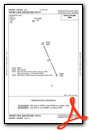
Instrument Approach Procedure (IAP) Charts
Departure Procedure (DP) Charts
Nearby Airports with Instrument Procedures
| ID | Name | Heading / Distance | ||
|---|---|---|---|---|
 |
3D2 | Ephraim/Gibraltar Airport | 216° | 18.8 |
|
KESC | Delta County Airport | 340° | 21.3 |
|
KMNM | Menominee Regional Airport | 242° | 34.1 |
|
KSUE | Door County Cherryland Airport | 213° | 38.9 |
|
KISQ | Schoolcraft County Airport | 041° | 47.3 |
|
KOCQ | Oconto/J Douglas Bake Municipal Airport | 233° | 52.0 |
|
KFKS | Frankfort Dow Memorial Field Airport | 145° | 55.2 |
|
KIMT | Ford Airport | 297° | 56.4 |
|
KSJX | Beaver Island Airport | 071° | 60.1 |
|
KSAW | Marquette/Sawyer Regional Airport | 341° | 61.0 |
|
KTVC | Cherry Capital Airport | 123° | 69.0 |
|
KCVX | Charlevoix Municipal Airport | 093° | 69.9 |
Airport Images
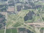
By: Big Orange Bird


Comments
Airport manager information
Airport telephone numbers outdated: former airport manager Walter Nehlon unfortunately passed away.
The new airport manager is Dick Donnelly, mobile phone 920-535-0546.
The tiedown area is at the south end of the grass, close to the Helipad.
The Lions Club makes available a courtesy airport Van, with a suggested donation per mile driven.
Call the Airport manager for the details.