Login
Register


39OK
Paradise Air Haven Airport
Official FAA Data Effective 2025-11-27 0901Z
VFR Chart of 39OK
Sectional Charts at SkyVector.com
IFR Chart of 39OK
Enroute Charts at SkyVector.com
Location Information for 39OK
Coordinates: N35°6.69' / W97°28.76'Located 02 miles S of Goldsby, Oklahoma on 100 acres of land. View all Airports in Oklahoma.
Estimated Elevation is 1205 feet MSL.
Operations Data
|
|
Airport Communications
| UNICOM: | 122.950 |
|---|---|
| AWOS-3PT at OUN (7.9 N): | 119.55 405-325-7302 |
| AWOS-1 at WX2 (8.1 N): | 119.55 817-222-4247 |
| ASOS at OKC (17.7 N): | 405-674-4013 |
Nearby Navigation Aids
|
| ||||||||||||||||||||||||||||||||||||||||||||||||||||||||||||


Runway 17/35
| Dimensions: | 4000 x 150 feet / 1219 x 46 meters | |
|---|---|---|
| Surface: | Turf | |
| Edge Lighting: | Low Intensity | |
| Runway 17 | Runway 35 | |
| Traffic Pattern: | Left | Right |
Services Available
| Fuel: | NONE |
|---|---|
| Transient Storage: | Hangars,Tiedowns |
| Airframe Repair: | NOT AVAILABLE |
| Engine Repair: | NOT AVAILABLE |
| Bottled Oxygen: | NOT AVAILABLE |
| Bulk Oxygen: | NOT AVAILABLE |
Ownership Information
| Ownership: | Privately Owned | |
|---|---|---|
| Owner: | PARADISE AIR HAVEN HOMEOWNERS ASSN | |
| 27458 AIRSTRIP ROAD | ||
| WASHINGTON, OK 73093 | ||
| 405-410-3408 | ||
| Manager: | BRIAN W. SOUTHARD | |
| 27458 AIRSTRIP ROAD | ||
| WASHINGTON, OK 73093 | ||
| 405-410-3408 | ||
Other Remarks
- FOR CD CTC OKE CITY APCH AT 405-681-5683.
- ACTVT LIRL RWY 17/35 - 122.95.
- FOR ROTG BCN CALL 405-288-6700.
Nearby Airports with Instrument Procedures
| ID | Name | Heading / Distance | ||
|---|---|---|---|---|
 |
1K4 | David Jay Perry Airport | 009° | 2.6 |
|
KOUN | University of Oklahoma Westheimer Airport | 002° | 8.0 |
|
KOKC | Okc Will Rogers International Airport | 340° | 17.9 |
|
KTIK | Tinker AFB Airport | 014° | 18.7 |
|
KCHK | Chickasha Municipal Airport | 268° | 24.1 |
|
KPWA | Wiley Post Airport | 342° | 26.6 |
|
KPVJ | Pauls Valley Municipal Airport | 152° | 27.2 |
|
KRCE | Clarence E Page Municipal Airport | 323° | 28.2 |
|
KSNL | Shawnee Regional Airport | 060° | 30.2 |
|
KHSD | Sundance Airport | 339° | 31.4 |
|
KRQO | El Reno Regional Airport | 310° | 33.7 |
|
KSRE | Seminole Municipal Airport | 075° | 40.7 |
Airport Images
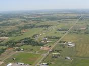
By: twwhitson


