Login
Register


3C1
Mishawaka Pilots Club Airport
Official FAA Data Effective 2026-02-19 0901Z
Chart Supplement

VFR Chart of 3C1
Sectional Charts at SkyVector.com
IFR Chart of 3C1
Enroute Charts at SkyVector.com
Location Information for 3C1
Coordinates: N41°39.42' / W86°2.08'Located 03 miles SW of Elkhart, Indiana on 69 acres of land. View all Airports in Indiana.
Estimated Elevation is 755 feet MSL.
Operations Data
|
|
Airport Communications
| CTAF: | 122.900 |
|---|---|
| AWOS-3 at EKM (4.0 N): | 124.475 574-264-9002 |
| ASOS at SBN (13.0 W): | 120.675 574-200-0869 |
| ATIS at SBN (13.0 W): | 120.675 |
Nearby Navigation Aids
|
| ||||||||||||||||||||||||||||||||||||||||||||||||||||||||||||


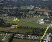
Runway 12/30
| Dimensions: | 3140 x 100 feet / 957 x 30 meters | |
|---|---|---|
| Surface: | Turf in Excellent Condition | |
| Runway 12 | Runway 30 | |
| Coordinates: | N41°39.50' / W86°2.32' | N41°39.30' / W86°1.85' |
| Elevation: | 752.0 | 753.0 |
| Traffic Pattern: | Left | Left |
| Displaced Threshold: | 690 Feet | 520 Feet |
| Markings: | Non-Standard | Non-Standard |
| Obstacles: | 75 ft Trees 255 ft from runway, 130 ft right of center APCH SLOPE 12:1 FM DTHR. |
45 ft Trees 180 ft from runway, 120 ft left of center |
Runway 03/21
| Dimensions: | 2243 x 40 feet / 684 x 12 meters | |
|---|---|---|
| Surface: | Asphalt in Good Condition | |
| Edge Lighting: | Low Intensity | |
| Runway 03 | Runway 21 | |
| Coordinates: | N41°39.17' / W86°2.20' | N41°39.55' / W86°1.95' |
| Elevation: | 755.0 | 750.0 |
| Traffic Pattern: | Left | Left |
| Displaced Threshold: | 187 Feet | 200 Feet |
| Markings: | Basic in fair condition. | Basic in fair condition. |
| Obstacles: | 15 ft Road 240 ft from runway, 125 ft right of center APCH SLOPE 28:1 FM DTHR. |
15 ft Road 240 ft from runway, 130 ft right of center APCH SLOPE 29:1 FM DTHR. |
Services Available
| Fuel: | NONE |
|---|---|
| Transient Storage: | Tiedowns |
| Airframe Repair: | NOT AVAILABLE |
| Engine Repair: | NOT AVAILABLE |
| Bottled Oxygen: | NOT AVAILABLE |
| Bulk Oxygen: | NOT AVAILABLE |
| Other Services: | PILOT INSTRUCTION |
Ownership Information
| Ownership: | Privately Owned | |
|---|---|---|
| Owner: | AIRPORT REALITY BOARD | |
| 29580 COUNTY ROAD 20 | ||
| ELKHART, IN 46517 | ||
| (574) 522-9025 | ||
| Manager: | CHRIS RINGOS | |
| 29580 COUNTY ROAD 20 | ||
| ELKHART, IN 46517 | ||
| (574) 675-7575 | ||
Other Remarks
- FOR CD CTC SOUTH BEND APCH 574-251-2609. WHEN SOUTH BEND APCH CLSD, FOR CD CTC CHICAGO ARTCC AT 630-906-8921.
- GND MKRS.
- GND MKRS.
- DUSK-DAWN.
Nearby Airports with Instrument Procedures
| ID | Name | Heading / Distance | ||
|---|---|---|---|---|
 |
KEKM | Elkhart Municipal Airport | 020° | 4.0 |
|
KSBN | South Bend International Airport | 283° | 13.1 |
|
KGSH | Goshen Municipal Airport | 125° | 13.4 |
|
C03 | Nappanee Municipal Airport | 160° | 13.4 |
|
3TR | Jerry Tyler Memorial Airport | 321° | 13.7 |
|
C91 | Dowagiac Municipal Airport | 348° | 20.6 |
|
C65 | Plymouth Municipal Airport | 214° | 21.2 |
|
C20 | Andrews University Airpark Airport | 319° | 23.1 |
|
KASW | Warsaw Municipal Airport | 158° | 24.5 |
|
KIRS | Kirsch Municipal Airport | 070° | 28.4 |
|
KPPO | La Porte Municipal Airport | 261° | 31.9 |
|
KBEH | Southwest Michigan Regional Airport | 328° | 33.2 |
Airport Images
By: Keith Vergon


