Login
Register


C03
Nappanee Municipal Airport
Official FAA Data Effective 2025-11-27 0901Z
Chart Supplement

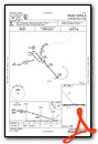
VFR Chart of C03
Sectional Charts at SkyVector.com
IFR Chart of C03
Enroute Charts at SkyVector.com
Location Information for C03
Coordinates: N41°26.77' / W85°56.16'Located 03 miles E of Nappanee, Indiana on 34 acres of land. View all Airports in Indiana.
Surveyed Elevation is 860 feet MSL.
Operations Data
|
|
Airport Communications
| SOUTH BEND APPROACH: | 132.05 257.8 |
|---|---|
| SOUTH BEND DEPARTURE: | 132.05 257.8 |
| UNICOM: | 123.000 |
| CTAF: | 123.000 |
| ASOS at GSH (8.3 NE): | 121.45 574-642-4231 |
| AWOS-3 at ASW (11.1 S): | 121.125 574-269-7035 |
| AWOS-3 at EKM (16.7 N): | 124.475 574-264-9002 |
- APCH/DEP SVC PRVDD BY CHICAGO ARTCC ON FREQS 135.9/314.0 (GOSHEN RCAG) WHEN SOUTH BEND APCH CTL CLSD.
Nearby Navigation Aids
|
| ||||||||||||||||||||||||||||||||||||||||||||||||||||||||||||


Runway 09/27
| Dimensions: | 3675 x 50 feet / 1120 x 15 meters | |
|---|---|---|
| Surface: | Asphalt in Good Condition | |
| Weight Limits: | S-7 | |
| Edge Lighting: | Medium Intensity FIRST 670 FT RWY 09 UNLGTD. | |
| Runway 09 | Runway 27 | |
| Coordinates: | N41°26.77' / W85°56.56' | N41°26.77' / W85°55.76' |
| Elevation: | 858.0 | 856.0 |
| Traffic Pattern: | Left | Left |
| Runway Heading: | 89° True | 269° True |
| Displaced Threshold: | 250 Feet | 185 Feet |
| Markings: | Basic in good condition. | Basic in good condition. |
| Obstacles: | 13 ft Road 265 ft from runway APCH RATIO 39:1 TO DTHR. |
5 ft Crops 201 ft from runway APCH RATIO 41:1 TO DTHR. 5 FT CROPS 20 - 200 FT FM RWY END ON CNTRLN. |
Services Available
| Fuel: | 100LL (blue) |
|---|---|
| Transient Storage: | Tiedowns |
| Airframe Repair: | NONE |
| Engine Repair: | NONE |
| Bottled Oxygen: | NOT AVAILABLE |
| Bulk Oxygen: | NOT AVAILABLE |
Ownership Information
| Ownership: | Publicly owned | |
|---|---|---|
| Owner: | NAPPANEE BOAC | |
| 24751 US6E | ||
| NAPPANEE, IN 46550 | ||
| 574-773-5027 | ||
| Manager: | LLOYD TURNER | |
| 24751 US6E | ||
| NAPPANEE, IN 46550 | ||
| 574-457-6476 | ||
Other Remarks
- DEER ON & INVOF ARPT.
- FOR CD CTC SOUTH BEND APCH AT 574-251-2609. WHEN SOUTH BEND APCH CLSD, FOR CD CTC CHICAGO ARTCC AT 630-906-8921.
- 0LL AVBL AFT HR WITH CREDIT CARD.
- ACTVT MIRL RWY 09/27 - CTAF.
Weather Minimums

Instrument Approach Procedure (IAP) Charts
Nearby Airports with Instrument Procedures
| ID | Name | Heading / Distance | ||
|---|---|---|---|---|
 |
KGSH | Goshen Municipal Airport | 053° | 8.0 |
|
KASW | Warsaw Municipal Airport | 157° | 11.2 |
|
KEKM | Elkhart Municipal Airport | 349° | 16.7 |
|
C65 | Plymouth Municipal Airport | 253° | 17.1 |
|
KSBN | South Bend International Airport | 312° | 23.3 |
|
KRCR | Fulton County Airport | 206° | 25.4 |
|
3TR | Jerry Tyler Memorial Airport | 331° | 26.7 |
|
C62 | Kendallville Municipal Airport | 086° | 30.5 |
|
KIRS | Kirsch Municipal Airport | 045° | 31.4 |
|
KOXI | Starke County Airport | 258° | 33.6 |
|
C91 | Dowagiac Municipal Airport | 345° | 33.9 |
|
C20 | Andrews University Airpark Airport | 327° | 36.0 |
Airport Images
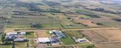
By: rvstuff
By: rjpkrp


