Login
Register


3F4
Vivian Airport
Official FAA Data Effective 2026-02-19 0901Z
Chart Supplement

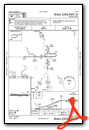
VFR Chart of 3F4
Sectional Charts at SkyVector.com
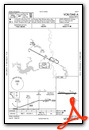
IFR Chart of 3F4
Enroute Charts at SkyVector.com
Location Information for 3F4
Coordinates: N32°51.68' / W94°0.61'Located 02 miles SW of Vivian, Louisiana on 182 acres of land. View all Airports in Louisiana.
Surveyed Elevation is 260 feet MSL.
Operations Data
|
|
Airport Communications
| SHREVEPORT APPROACH: | 119.9 335.55 |
|---|---|
| SHREVEPORT DEPARTURE: | 119.9 335.55 |
| UNICOM: | 122.800 |
| CTAF: | 122.800 |
| AWOS-3 at ATA (17.1 NW): | 118.250 903-799-4066 |
| ASOS at DTN (23.5 SE): | 118.525 318-425-7967 |
| AWOS-3PT at ASL (25.3 SW): | 118.675 903-938-2060 |
Nearby Navigation Aids
|
| ||||||||||||||||||||||||||||||||||||||||||||||||||||||||||||


Runway 09/27
| Dimensions: | 2998 x 75 feet / 914 x 23 meters | |
|---|---|---|
| Surface: | Asphalt in Good Condition | |
| Weight Limits: | S-12 | |
| Edge Lighting: | Medium Intensity | |
| Runway 09 | Runway 27 | |
| Coordinates: | N32°51.68' / W94°0.90' | N32°51.68' / W94°0.32' |
| Elevation: | 247.0 | 259.0 |
| Traffic Pattern: | Left | Left |
| Runway Heading: | 90° True | 270° True |
| Markings: | Non-Precision Instrument in good condition. | Non-Precision Instrument in good condition. |
| Glide Slope Indicator | P2L (3.00° Glide Path Angle) RWY 09 PAPI OTS - PAPIS ARE NOT COMMISSIONED | P2L (3.00° Glide Path Angle) RWY 27 PAPI OTS - PAPIS ARE NOT COMMISSIONED |
| REIL: | Yes | Yes |
| Obstacles: | 27 ft Trees 720 ft from runway, 62 ft left of center | 106 ft Trees 2392 ft from runway, 208 ft right of center |
Services Available
| Fuel: | 100LL (blue) |
|---|---|
| Transient Storage: | Hangars,Tiedowns |
| Airframe Repair: | MAJOR |
| Engine Repair: | MAJOR |
| Bottled Oxygen: | NONE |
| Bulk Oxygen: | NONE |
| Other Services: | CROP DUSTING SERVICES,PILOT INSTRUCTION |
Ownership Information
| Ownership: | Publicly owned | |
|---|---|---|
| Owner: | TOWN OF VIVIAN | |
| P. O. BOX 832 | ||
| VIVIAN, LA 71082 | ||
| 318-375-3856 | ||
| Manager: | MR. MARTY MUSICK | |
| P. O. BOX 648 | ||
| VIVIAN, LA 71082 | ||
| (318) 455-5499 | ||
Other Remarks
- THIS AIRPORT HAS BEEN SURVEYED BY THE NATIONAL GEODETIC SURVEY.
- GCO AVBL ON FREQ 135.075 THRU BAD APCH CTL AND FLT SVCS.
- FOR CD IF UNA VIA GCO CTC FORT WORTH ARTCC AT 817-858-7584.
- CTC ARPT MGR FOR DSNGD RAMP SPACE FOR PUB USE AT THE ARPT
- 0LL FUEL AVBL 24 HRS SELF SVC WITH CREDIT CARD.
- MIRL RY 09/27 AND REIL RY 09 PRESET LOW INTST DUSK-DAWN; TO INCR INTST ACTVT - CTAF.
Weather Minimums

Instrument Approach Procedure (IAP) Charts

Nearby Airports with Instrument Procedures
| ID | Name | Heading / Distance | ||
|---|---|---|---|---|
 |
KATA | Hall-Miller Municipal Airport | 327° | 17.2 |
|
KDTN | Shreveport Downtown Airport | 144° | 23.5 |
|
KASL | Harrison County Airport | 216° | 25.4 |
|
KSHV | Shreveport Regional Airport | 159° | 26.5 |
|
KBAD | Barksdale AFB Airport | 140° | 27.8 |
|
KSPH | Springhill Airport | 076° | 31.2 |
|
KTXK | Texarkana Regional-Webb Field Airport | 001° | 35.5 |
|
KMNE | Minden Airport | 109° | 38.3 |
|
4F2 | Panola County-Sharpe Field Airport | 199° | 43.6 |
|
KAGO | Ralph C Weiser Field Airport | 061° | 45.6 |
|
KGGG | East Texas Regional Airport | 231° | 45.6 |
|
KJXI | Fox Stephens Field/Gilmer Municipal Airport | 258° | 48.5 |
Airport Images
Do you have a recent image of this airport? Upload it here!


