Login
Register


MNE
Minden Airport
Official FAA Data Effective 2026-02-19 0901Z
Chart Supplement

VFR Chart of KMNE
Sectional Charts at SkyVector.com
IFR Chart of KMNE
Enroute Charts at SkyVector.com
Location Information for KMNE
Coordinates: N32°38.76' / W93°17.88'Located 02 miles NW of Minden, Louisiana on 35 acres of land. View all Airports in Louisiana.
Surveyed Elevation is 278 feet MSL.
Operations Data
|
|
Airport Communications
| AWOS-3PT: | 119.325 Tel. 318-371-7874 |
|---|---|
| SHREVEPORT APPROACH: | 123.75 360.725 |
| SHREVEPORT DEPARTURE: | 123.75 360.725 |
| UNICOM: | 122.800 |
| CTAF: | 122.800 |
| ATIS at BAD (20.4 SW): | 307.025 |
| ASOS at DTN (23.5 W): | 118.525 318-425-7967 |
| ASOS at SHV (29.3 SW): | 128.45 318-216-0546 |
Nearby Navigation Aids
|
| ||||||||||||||||||||||||||||||||||||||||||||||||||||||||||||


Runway 01/19
| Dimensions: | 5004 x 75 feet / 1525 x 23 meters | |
|---|---|---|
| Surface: | Asphalt in Excellent Condition | |
| Weight Limits: | S-30, D-45 | |
| Edge Lighting: | Medium Intensity | |
| Runway 01 | Runway 19 | |
| Coordinates: | N32°38.36' / W93°18.02' | N32°39.16' / W93°17.75' |
| Elevation: | 277.6 | 261.8 |
| Traffic Pattern: | Left | Left |
| Runway Heading: | 16° True | 196° True |
| Markings: | Non-Precision Instrument in fair condition. | Non-Precision Instrument in fair condition. |
| Glide Slope Indicator | P2L (3.15° Glide Path Angle) | P2L (3.75° Glide Path Angle) |
| REIL: | Yes | Yes |
| Obstacles: | 53 ft Trees 1583 ft from runway, 317 ft right of center | 28 ft Trees 291 ft from runway, 127 ft right of center |
Services Available
| Fuel: | 100LL (blue), Jet A+ |
|---|---|
| Transient Storage: | Hangars,Tiedowns |
| Airframe Repair: | NOT AVAILABLE |
| Engine Repair: | NOT AVAILABLE |
| Bottled Oxygen: | NONE |
| Bulk Oxygen: | NONE |
| Other Services: | PILOT INSTRUCTION |
Ownership Information
| Ownership: | Publicly owned | |
|---|---|---|
| Owner: | CITY OF MINDEN | |
| PO BOX 580 | ||
| MINDEN, LA 71055-0580 | ||
| 318-377-2144 | ||
| Manager: | MOLLY FOWLER | |
| 100 AVIATION DRIVE | ||
| MINDEN, LA 71055 | ||
| 318-371-7862 | ||
Other Remarks
- THIS AIRPORT HAS BEEN SURVEYED BY THE NATIONAL GEODETIC SURVEY.
- GCO AVBL ON FREQ 135.075 THRU BAD RAPCON.
- BIRDS ON & INVOF ARPT.
- FOR CD IF UNA VIA GCO CTC FORT WORTH ARTCC AT 817-858-7584.
- CTC ARPT MGR FOR DSNGD RAMP SPACE FOR PUB USE AT ARPT
- ACTVT MIRL RY 01/19 - CTAF.
Weather Minimums


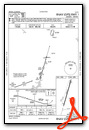
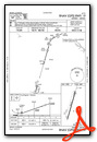
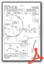
Instrument Approach Procedure (IAP) Charts
Nearby Airports with Instrument Procedures
| ID | Name | Heading / Distance | ||
|---|---|---|---|---|
 |
KBAD | Barksdale AFB Airport | 245° | 20.4 |
|
KSPH | Springhill Airport | 344° | 21.0 |
|
KDTN | Shreveport Downtown Airport | 254° | 23.5 |
|
KSHV | Shreveport Regional Airport | 246° | 29.3 |
|
KAGO | Ralph C Weiser Field Airport | 006° | 35.1 |
|
KRSN | Ruston Regional Airport | 102° | 36.8 |
|
3F4 | Vivian Airport | 289° | 38.3 |
|
F88 | Jonesboro Airport | 132° | 39.1 |
|
0R7 | The Red River Airport | 180° | 39.3 |
|
3F3 | C E 'Rusty' Williams Airport | 214° | 41.7 |
|
KELD | South Arkansas Regional At Goodwin Field Airport | 035° | 42.3 |
|
KASL | Harrison County Airport | 261° | 51.7 |
Airport Images

By: sburdeaux


