Login
Register


SHV
Shreveport Regional Airport
Official FAA Data Effective 2026-02-19 0901Z
Chart Supplement

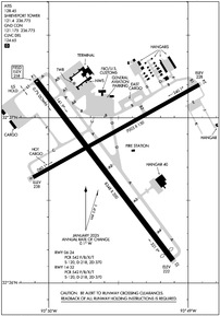
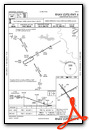
KSHV Airport Diagram
VFR Chart of KSHV
Sectional Charts at SkyVector.com
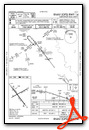
IFR Chart of KSHV
Enroute Charts at SkyVector.com
Location Information for KSHV
Coordinates: N32°26.79' / W93°49.56'Located 04 miles SW of Shreveport, Louisiana on 1625 acres of land. View all Airports in Louisiana.
Surveyed Elevation is 257 feet MSL.
Operations Data
|
|
Airport Communications
| ATIS: | 128.45 |
|---|---|
| ASOS: | 128.45 Tel. 318-216-0546 |
| SHREVEPORT TOWER: | 121.4 236.775 |
| SHREVEPORT GROUND: | 121.175 236.775 |
| SHREVEPORT APPROACH: | 119.9 335.55 |
| SHREVEPORT DEPARTURE: | 119.9 335.55 |
| CLEARANCE DELIVERY: | 124.65 |
| UNICOM: | 122.950 |
| EMERG: | 121.5 243.0 |
| ASOS at DTN (6.9 NE): | 118.525 318-425-7967 |
| ATIS at BAD (8.9 E): | 307.025 |
| AWOS-3PT at 3F3 (22.7 S): | 119.125 318-872-3537 |
Nearby Navigation Aids
|
| ||||||||||||||||||||||||||||||||||||||||||||||||||||||||||||


Runway 14/32
| Dimensions: | 8348 x 200 feet / 2544 x 61 meters | |
|---|---|---|
| Surface: | Asphalt / Grooved in Excellent Condition | |
| Weight Limits: | S-120, D-218, ST-370
PCR VALUE: 542/F/B/X/T
| |
| Edge Lighting: | High Intensity | |
| Runway 14 | Runway 32 | |
| Coordinates: | N32°27.23' / W93°50.09' | N32°26.14' / W93°49.11' |
| Elevation: | 257.6 | 222.1 |
| Traffic Pattern: | Left | Left |
| Runway Heading: | 143° True | 323° True |
| Displaced Threshold: | 373 Feet | |
| Declared Distances: | TORA:8348 TODA:8348 ASDA:8118 LDA:8118 | TORA:8348 TODA:8348 ASDA:8348 LDA:7975 |
| Markings: | Precision Instrument in good condition. | Precision Instrument in good condition. |
| Glide Slope Indicator | P4R (3.00° Glide Path Angle) | |
| RVR Equipment | Touchdown Midfield Rollout | Touchdown Midfield Rollout |
| Approach Lights: | ALSF2 Standard 2,400 Foot High-intensity Approach Lighting System with sequenced flashers, CATEGORY II or III Configuration. | MALSR 1,400 Foot Medium-intensity Approach Lighting System with runway alignment indicator lights. |
| Centerline Lights: | Yes | Yes |
| Obstacles: | 32 ft Railroad 920 ft from runway, 600 ft right of center APCH RATIO 40:1 FM DSPLCD THR. |
|
Runway 06/24
| Dimensions: | 7003 x 150 feet / 2135 x 46 meters | |
|---|---|---|
| Surface: | Asphalt / Grooved in Excellent Condition | |
| Weight Limits: | S-120, D-218, ST-370
PCR VALUE: 542/F/B/X/T
| |
| Edge Lighting: | Medium Intensity | |
| Runway 06 | Runway 24 | |
| Coordinates: | N32°26.64' / W93°50.11' | N32°27.20' / W93°48.92' |
| Elevation: | 238.3 | 228.4 |
| Traffic Pattern: | Left | Left |
| Runway Heading: | 61° True | 241° True |
| Declared Distances: | TORA:7003 TODA:7003 ASDA:7003 LDA:7003 | TORA:7003 TODA:7003 ASDA:7003 LDA:7003 |
| Markings: | Non-Precision Instrument in good condition. | Non-Precision Instrument in good condition. |
| Glide Slope Indicator | P4L (3.00° Glide Path Angle) | P4L (3.00° Glide Path Angle) |
| REIL: | Yes | Yes |
| Obstacles: | 77 ft Trees 2000 ft from runway, 300 ft right of center | 111 ft Trees 3800 ft from runway |
Services Available
| Fuel: | 100LL (blue), Jet-A |
|---|---|
| Transient Storage: | Hangars,Tiedowns |
| Airframe Repair: | MAJOR |
| Engine Repair: | MAJOR |
| Bottled Oxygen: | HIGH |
| Bulk Oxygen: | NOT AVAILABLE |
| Other Services: | AIR FREIGHT SERVICES,AVIONICS,CARGO HANDLING SERVICES,CHARTER SERVICE |
Ownership Information
| Ownership: | Publicly owned | |
|---|---|---|
| Owner: | CITY OF SHREVEPORT | |
| 505 TRAVIS STREET | ||
| SHREVEPORT, LA 71101 | ||
| 318-673-5050 | ||
| Manager: | LARRY BLACKWELL | |
| 5103 HOLLYWOOD AVE SUITE 300 | ||
| SHREVEPORT, LA 71109 | ||
| 318-673-5370 | ||
Other Remarks
- FLIGHT NOTIFICATION SERVICE (ADCUS) AVBL MON-FRI 0800-1700; OTHER TIMES BY APPOINTMENT CALL 318-635-7873 OR 800-973-2867.
- BIRD ACTIVITY INVOF ARPT.
- LNDG FEE FOR ALL COMMERCIAL TFC.
Weather Minimums


Instrument Approach Procedure (IAP) Charts


Nearby Airports with Instrument Procedures
| ID | Name | Heading / Distance | ||
|---|---|---|---|---|
 |
KDTN | Shreveport Downtown Airport | 036° | 7.0 |
|
KBAD | Barksdale AFB Airport | 068° | 8.9 |
|
3F3 | C E 'Rusty' Williams Airport | 172° | 22.6 |
|
KASL | Harrison County Airport | 280° | 24.8 |
|
3F4 | Vivian Airport | 339° | 26.5 |
|
4F2 | Panola County-Sharpe Field Airport | 236° | 29.0 |
|
KMNE | Minden Airport | 065° | 29.3 |
|
0R7 | The Red River Airport | 135° | 38.0 |
|
KSPH | Springhill Airport | 033° | 38.5 |
|
F17 | Center Municipal Airport | 204° | 40.5 |
|
KATA | Hall-Miller Municipal Airport | 334° | 43.5 |
|
KGGG | East Texas Regional Airport | 265° | 45.1 |
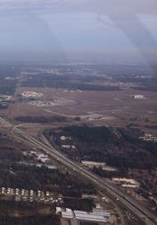
Airport Images

By: Big Orange Bird
By: bitgent


