Login
Register


45R
Hawthorne Field Airport
Official FAA Data Effective 2026-01-22 0901Z
Chart Supplement

VFR Chart of 45R
Sectional Charts at SkyVector.com
IFR Chart of 45R
Enroute Charts at SkyVector.com
Location Information for 45R
Coordinates: N30°20.18' / W94°15.45'Located 03 miles SE of Kountze/Silsbee, Texas on 167 acres of land. View all Airports in Texas.
Surveyed Elevation is 70 feet MSL.
Operations Data
|
|
Airport Communications
| HOUSTON APPROACH: | 121.3 377.1 |
|---|---|
| HOUSTON DEPARTURE: | 121.3 377.1 |
| CTAF: | 122.800 |
| UNICOM: | 122.800 |
| AWOS-3PT at BMT (16.2 S): | 118.425 409-866-2832 |
| ASOS at BPT (26.0 SE): | 126.3 409-223-4011 |
| ATIS at BPT (26.2 SE): | 126.3 |
Nearby Navigation Aids
|
| ||||||||||||||||||||||||||||||||||||||||||||||||||||||||||||


Runway 13/31
| Dimensions: | 4303 x 76 feet / 1312 x 23 meters | |
|---|---|---|
| Surface: | Asphalt in Good Condition | |
| Weight Limits: | S-12 | |
| Edge Lighting: | Medium Intensity | |
| Runway 13 | Runway 31 | |
| Coordinates: | N30°20.45' / W94°15.72' | N30°19.91' / W94°15.19' |
| Elevation: | 68.7 | 65.4 |
| Traffic Pattern: | Left | Left |
| Runway Heading: | 140° True | 320° True |
| Markings: | Non-Precision Instrument in poor condition. | Non-Precision Instrument in poor condition. |
| Glide Slope Indicator | P2L (3.00° Glide Path Angle) | P2L (4.00° Glide Path Angle) PAPI OTS |
| Obstacles: | 90 ft Tree 1736 ft from runway, 380 ft right of center | 65 ft Tree 935 ft from runway |
Services Available
| Fuel: | 100LL (blue), Jet-A |
|---|---|
| Transient Storage: | Tiedowns |
| Airframe Repair: | NOT AVAILABLE |
| Engine Repair: | NOT AVAILABLE |
| Bottled Oxygen: | NOT AVAILABLE |
| Bulk Oxygen: | NOT AVAILABLE |
| Other Services: | PILOT INSTRUCTION,AIRCRAFT RENTAL |
Ownership Information
| Ownership: | Publicly owned | |
|---|---|---|
| Owner: | HARDIN COUNTY | |
| PO BOX 760 | ||
| KOUNTZE, TX 77625 | ||
| 409-246-5120 | ||
| Manager: | DALE WILLIFORD | |
| PO BOX 502 | ||
| KOUNTZE, TX 77625 | ||
| 409-782-7620 | ||
Other Remarks
- FOR CD CTC HOUSTON APCH AT 281-443-5844 TO CNL IFR CALL 281-443-5888.
- RY & TWY MKGS INCLUDING HOLD LINES FADED.
- 0LL 24 HR SELF SERVE FUEL.
- MIRL RY 13/31 PRESET LOW INTST DUSK-DAWN; TO INCR INTST ACTVT - CTAF.
Weather Minimums

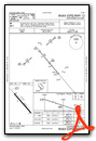
Instrument Approach Procedure (IAP) Charts
Nearby Airports with Instrument Procedures
| ID | Name | Heading / Distance | ||
|---|---|---|---|---|
 |
KBMT | Beaumont Municipal Airport | 172° | 16.1 |
|
KBPT | Jack Brooks Regional Airport | 151° | 26.2 |
|
T78 | Liberty Municipal Airport | 236° | 27.7 |
|
KORG | Orange County Airport | 124° | 28.5 |
|
T90 | Chambers County/Winnie Stowell Airport | 196° | 32.3 |
|
KJAS | Jasper County/Bell Field Airport | 019° | 34.8 |
|
6R3 | Cleveland Municipal Airport | 271° | 39.0 |
|
T00 | Chambers County Airport | 212° | 40.0 |
|
5R8 | De Quincy Industrial Airpark Airport | 081° | 41.2 |
|
00R | Livingston Municipal Airport | 298° | 44.6 |
|
54T | Rwj Airpark Airport | 221° | 46.1 |
|
KUXL | Southland Field Airport | 104° | 47.4 |
Airport Images
Do you have a recent image of this airport? Upload it here!


