Login
Register


5R8
De Quincy Industrial Airpark Airport
Official FAA Data Effective 2025-12-25 0901Z
Chart Supplement

VFR Chart of 5R8
Sectional Charts at SkyVector.com
IFR Chart of 5R8
Enroute Charts at SkyVector.com
Location Information for 5R8
Coordinates: N30°26.46' / W93°28.42'Located 02 miles SW of De Quincy, Louisiana on 79 acres of land. View all Airports in Louisiana.
Surveyed Elevation is 82 feet MSL.
Operations Data
|
|
Airport Communications
| AWOS-3PT: | 121.2 Tel. 337-786-1518 |
|---|---|
| LAKE CHARLES APPROACH: | 119.35 282.3 |
| LAKE CHARLES DEPARTURE: | 119.35 282.3 |
| CTAF: | 122.800 |
| UNICOM: | 122.800 |
| AWOS-3PT at UXL (19.3 S): | 118.175 337-558-5321 |
| AWOS-3 at CWF (22.0 SE): | 120.0 337-214-2134 |
| ATIS at CWF (22.0 SE): | 120.0 |
- APCH/DEP SVC PRVDD BY HOUSTON ARTCC (ZHU) ON FREQS 124.7/317.4 (LAKE CHARLES RCAG) WHEN LAKE CHARLES APCH CTL (LCH) CLSD.
Nearby Navigation Aids
|
| ||||||||||||||||||||||||||||||||||||||||||||||||||||||||||||


Runway 16/34
| Dimensions: | 4997 x 75 feet / 1523 x 23 meters | |
|---|---|---|
| Surface: | Asphalt in Good Condition | |
| Weight Limits: | S-18 | |
| Edge Lighting: | Medium Intensity | |
| Runway 16 | Runway 34 | |
| Coordinates: | N30°26.85' / W93°28.60' | N30°26.08' / W93°28.23' |
| Elevation: | 72.7 | 80.7 |
| Traffic Pattern: | Left | Left |
| Runway Heading: | 157° True | 337° True |
| Markings: | Non-Precision Instrument in good condition. | Non-Precision Instrument in good condition. |
| Glide Slope Indicator | P2L (3.00° Glide Path Angle) | P2L (3.00° Glide Path Angle) |
| REIL: | Yes | Yes |
| Obstacles: | 59 ft Tree 1468 ft from runway | 43 ft Trees 1573 ft from runway, 280 ft right of center |
Services Available
| Fuel: | 100LL (blue) |
|---|---|
| Transient Storage: | Hangars,Tiedowns MUST PRVD ROPE AND CAULKS |
| Airframe Repair: | MINOR EMERG AIRFRAME RPR AVBL CALL ARPT MGR FOR DETAILS. |
| Engine Repair: | MINOR EMERG PWR PLANT RPR AVBL CALL ARPT MGR FOR DETAILS. |
| Bottled Oxygen: | NONE |
| Bulk Oxygen: | NONE |
| Other Services: | CROP DUSTING SERVICES |
Ownership Information
| Ownership: | Publicly owned | |
|---|---|---|
| Owner: | CITY OF DE QUINCY | |
| PO BOX 968 | ||
| DE QUINCY, LA 70633 | ||
| 337-786-8211 | ||
| Manager: | KYLE RAINWATER | |
| PO BOX 968 | ||
| DE QUINCY, LA 70633 | ||
| 337-660-3488 | ||
Other Remarks
- FOR CD CTC LAKE CHARLES APCH AT 337-480-3103, WHEN APCH CLSD CTC HOUSTON ARTCC AT 281-230-5622.
- COURTESY CAR AND PILOTS LOUNGE AVBL.
- 0LL SELF SERVICE FUEL WITH CREDIT CARD.
- MIRL RY 16/34, REIL RYS 16 & 34 PRESET LOW INTST DUSK-DAWN; TO INCR INTST ACTVT - CTAF.
Weather Minimums
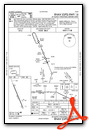
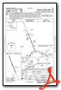
Instrument Approach Procedure (IAP) Charts
Nearby Airports with Instrument Procedures
| ID | Name | Heading / Distance | ||
|---|---|---|---|---|
 |
KUXL | Southland Field Airport | 164° | 19.2 |
|
KCWF | Chennault International Airport | 128° | 22.0 |
|
KLCH | Lake Charles Regional Airport | 145° | 22.9 |
|
KDRI | Beauregard Regional Airport | 016° | 24.4 |
|
KORG | Orange County Airport | 217° | 28.1 |
|
6R1 | Welsh Airport | 109° | 35.4 |
|
KJAS | Jasper County/Bell Field Airport | 312° | 39.4 |
|
KBPT | Jack Brooks Regional Airport | 224° | 40.9 |
|
45R | Hawthorne Field Airport | 261° | 41.2 |
|
3R7 | Jennings Airport | 105° | 43.2 |
|
L39 | Leesville Airport | 008° | 44.1 |
|
KBMT | Beaumont Municipal Airport | 240° | 44.5 |
Airport Images
Do you have a recent image of this airport? Upload it here!


Comments
The FBO is closed but there is a good quality 24 hour SS fuel
The FBO is closed but there is a good quality 24 hour SS fuel system. Two(2) porta potties are the only facility that I could find but that is okay for a cheap fuel stop. Onward.