Login
Register


5AZ3
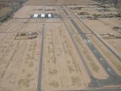
Pegasus Airpark Airport
Official FAA Data Effective 2026-02-19 0901Z
VFR Chart of 5AZ3
Sectional Charts at SkyVector.com
IFR Chart of 5AZ3
Enroute Charts at SkyVector.com
Location Information for 5AZ3
Coordinates: N33°12.52' / W111°37.03'Located 03 miles N of Queen Creek, Arizona on 320 acres of land. View all Airports in Arizona.
Estimated Elevation is 1451 feet MSL.
Operations Data
|
|
Airport Communications
| CTAF: | 123.050 |
|---|---|
| AWOS-3 at IWA (5.7 N): | 133.5 480-988-9428 |
| ATIS at IWA (6.3 N): | 270.275 |
| AWOS-3PT at CHD (10.2 W): | 480-814-9952 |
Nearby Navigation Aids
|
| ||||||||||||||||||||||||||||||||||||

Runway 08/26
| Dimensions: | 5124 x 80 feet / 1562 x 24 meters | |
|---|---|---|
| Surface: | Asphalt | |
| Edge Lighting: | High Intensity | |
| Runway 08 | Runway 26 | |
| Coordinates: | N33°12.52' / W111°37.54' | N33°12.53' / W111°36.53' |
| Elevation: | 1436.9 | 1451.3 |
| Displaced Threshold: | 921 Feet | 911 Feet |
| Obstacles: | 175 ft Power Line 1519 ft from runway | 175 ft Power Line 1519 ft from runway |
Ownership Information
| Ownership: | Privately Owned | |
|---|---|---|
| Owner: | PEGASUS AIRPARK FLIGHT ASSOCIATION | |
| 150 E ALAMO DR #3 | ||
| CHANDLER, AZ 85225 | ||
| 480-967-7182 | X103 | |
| Manager: | METRO PROPERTY SVC | NELSON GARRISON - 602-571-3297; PAT MCCLURE - 602-432-3086; DJ VEGH - 602-743-5768. |
| 150 E ALAMO DR #3 | ||
| CHANDLER, AZ 85225 | ||
| 480-967-7182 | ||
Other Remarks
- 175 FT PWR LINE 1/4 NM S & PARL TO RWY.
- PUB ACES NA.
- FOR CD CTC PHOENIX APCH AT 602-306-2565.
- ACTVT HIRL RWY 08/26 - CTAF.
Nearby Airports with Instrument Procedures
| ID | Name | Heading / Distance | ||
|---|---|---|---|---|
 |
KIWA | Mesa Gateway Airport | 342° | 6.2 |
|
KCHD | Chandler Municipal Airport | 290° | 10.4 |
|
P19 | Stellar Airpark Airport | 289° | 16.0 |
|
KFFZ | Falcon Field Airport | 339° | 16.1 |
|
KCGZ | Casa Grande Municipal Airport | 206° | 17.0 |
|
P08 | Coolidge Municipal Airport | 149° | 19.0 |
|
KPHX | Phoenix Sky Harbor International Airport | 304° | 24.0 |
|
KSDL | Scottsdale Airport | 329° | 28.8 |
|
KDVT | Phoenix Deer Valley Airport | 321° | 37.0 |
|
KGEU | Glendale Regional Airport | 299° | 39.0 |
|
KGYR | Phoenix Goodyear Airport | 288° | 40.2 |
|
KLUF | Luke AFB Airport | 297° | 43.2 |


Comments
It says located north of
It says located north of queen creek, actually located south of queen creek. The manager is not brown property and they will not answer phone questions. Very hard to see windsocks faded. Touch and goes frowned upon by township. Some residents and hangar owners very friendly to visitors.
windsocks replaced
The Windsocks have been replaced and 'finally' the retention areas between the runway and taxiways have been filled and regraded. Lots of new houses being built and new hangars proposed. Housing sales in the area have increased by over 30 %.
Pages