Login
Register


5CA8
Howard /Private/ Airport
Official FAA Data Effective 2026-01-22 0901Z
VFR Chart of 5CA8
Sectional Charts at SkyVector.com
IFR Chart of 5CA8
Enroute Charts at SkyVector.com
Location Information for 5CA8
Coordinates: N38°15.38' / W120°55.90'Located 05 miles S of Ione, California. View all Airports in California.
Estimated Elevation is 480 feet MSL.
Operations Data
|
|
Airport Communications
| AWOS-3 at JAQ (9.6 NE): | 121.125 209-257-1292 |
|---|---|
| AWOS-3P at CPU (15.1 SE): | 118.525 209-736-2523 |
| AWOS-3PT at MHR (24.9 NW): | 118.325 916-366-3371 |
Nearby Navigation Aids
|
| ||||||||||||||||||||||||||||||||||||


Runway 07/25
| Dimensions: | 1481 x 40 feet / 451 x 12 meters | |
|---|---|---|
| Surface: | Dirt | |
| Runway 07 | Runway 25 | |
| Traffic Pattern: | Right | Left |
| Obstacles: | ft Power Line 1300 ft from runway | ft Power Line 700 ft from runway |
Ownership Information
| Ownership: | Privately Owned | |
|---|---|---|
| Owner: | CHARLES D MEINTZ/ANN MEINTZ | |
| 4875 CAMANCHE PKWY NORTH | ||
| IONE, CA 95640 | ||
| 650-868-6750 | ||
| Manager: | CHARLES D MEINTZ | |
| 4875 CAMANCHE PKWY NORTH | ||
| IONE, CA 95640 | ||
| 650-868-6750 | ||
Other Remarks
- RUNWAY SLOPES CONSIDERABLY DOWNHILL TO WEST.
- FOR CD CTC NORCAL APCH AT 916-361-0516.
Nearby Airports with Instrument Procedures
| ID | Name | Heading / Distance | ||
|---|---|---|---|---|
 |
KJAQ | Westover Field Amador County Airport | 041° | 9.7 |
|
KCPU | Calaveras County/Maury Rasmussen Field Airport | 116° | 14.9 |
|
1O3 | Lodi Airport | 258° | 16.3 |
|
KMHR | Sacramento Mather Airport | 316° | 24.9 |
|
KSCK | Stockton Metro Airport | 213° | 26.1 |
|
O22 | Columbia Airport | 118° | 28.0 |
|
KPVF | Placerville Airport | 016° | 29.3 |
|
KSAC | Sacramento Exec Airport | 300° | 30.6 |
|
O27 | Oakdale Airport | 168° | 30.6 |
|
KMCC | Mc Clellan Airfield Airport | 318° | 33.1 |
|
O88 | Rio Vista Municipal Airport | 264° | 36.7 |
|
KMOD | Modesto City-County-Harry Sham Field Airport | 181° | 37.8 |
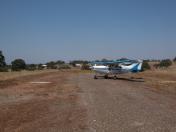
Airport Images

By: KH
By: KH


