Login
Register
5D5
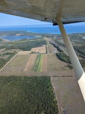
Woolsey Memorial Airport
Official FAA Data Effective 2026-01-22 0901Z
VFR Chart of 5D5
Sectional Charts at SkyVector.com
IFR Chart of 5D5
Enroute Charts at SkyVector.com
Location Information for 5D5
Coordinates: N45°9.86' / W85°34.53'Located 03 miles NE of Northport, Michigan on 50 acres of land. View all Airports in Michigan.
Surveyed Elevation is 628 feet MSL.
Operations Data
|
|
Airport Communications
| CTAF: | 122.900 |
|---|---|
| AWOS-3P at CVX (15.4 NE): | 120.0 231-237-9703 |
| AWOS-3P at ACB (19.1 SE): | 119.275 231-533-8941 |
| ATIS at TVC (25.4 S): | 119.175 |
Nearby Navigation Aids
|
| ||||||||||||||||||||||||||||||||||||||||||||||||||||||||||||
Runway 09/27
| Dimensions: | 3663 x 120 feet / 1116 x 37 meters | |
|---|---|---|
| Surface: | Turf in Good Condition UPSLP FM WEST TO EAST. | |
| Edge Lighting: | Low Intensity | |
| Runway 09 | Runway 27 | |
| Coordinates: | N45°9.76' / W85°35.07' | N45°9.79' / W85°34.22' |
| Elevation: | 616.0 | 623.0 |
| Traffic Pattern: | Left | Left |
| Runway Heading: | 87° True | 267° True |
| Displaced Threshold: | 266 Feet | |
| Obstacles: | 14 ft Road 35 ft from runway APCH RATIO 20:1 TO DTHR. |
60 ft Trees 1330 ft from runway, 100 ft left of center |
Runway 16/34
| Dimensions: | 2670 x 150 feet / 814 x 46 meters | |
|---|---|---|
| Surface: | Turf in Fair Condition UPSLP FM NORTH TO SOUTH. | |
| Runway 16 | Runway 34 | |
| Coordinates: | N45°10.18' / W85°34.48' | N45°9.77' / W85°34.26' |
| Elevation: | 605.0 | 625.0 |
| Traffic Pattern: | Left | Left |
| Runway Heading: | 159° True | 339° True |
| Displaced Threshold: | 770 Feet | 300 Feet |
| Obstacles: | 27 ft Trees 0 ft from runway, 122 ft right of center APCH RATIO 20:1 TO DTHR OVR +48 FT TREE, 960 FT DIST, 125 FT R. |
10 ft Road 50 ft from runway CTLG OBSTN EXCEEDS A 45 DEG SLP. APCH RATIO 18:1 TO DTHR OVR 34 FT TREE, 620 FT DIST; 25:1 OVR 17 FT BLDG, 425 FT DIST, L OF CNTRLN. |
Services Available
| Fuel: | NONE |
|---|---|
| Transient Storage: | Tiedowns |
| Airframe Repair: | NOT AVAILABLE |
| Engine Repair: | NOT AVAILABLE |
| Bottled Oxygen: | NOT AVAILABLE |
| Bulk Oxygen: | NOT AVAILABLE |
Ownership Information
| Ownership: | Publicly owned | |
|---|---|---|
| Owner: | LEELANAU TWP | |
| 119 E NAGONABA ST, PO BOX 338 | ||
| NORTHPORT, MI 49670-0338 | ||
| 231-386-5282 | ||
| Manager: | THOMAS M WETHERBEE | |
| PO BOX 338 | ||
| NORTHPORT, MI 49670-0338 | ||
| 231-386-9841 | ||
Other Remarks
- ARPT CLSD NOV-MAR & WHEN SNOW COVD EXC FOR SKI EQUIPPED ACFT.
- DEER, BIRDS, & WILDLIFE ON & INVOF ARPT.
- FOR CD CTC MINNEAPOLIS ARTCC AT 651-463-5588.
- RWY & DTHR MKD WITH 3 FT YELLOW CONES.
- RWY & DTHR MKD WITH 3 FT YELLOW CONES.
- 3 FT YELLOW CONES.
- RWY & DTHR MKD WITH 3 FT YELLOW CONES.
- ACTVT LIRL RWY 09/27 - CTAF.
Nearby Airports with Instrument Procedures
| ID | Name | Heading / Distance | ||
|---|---|---|---|---|
 |
KCVX | Charlevoix Municipal Airport | 056° | 15.3 |
 |
KACB | Antrim County Airport | 123° | 19.2 |
 |
N98 | Boyne City Municipal Airport | 083° | 25.0 |
 |
KTVC | Cherry Capital Airport | 180° | 25.4 |
 |
KBFA | Boyne Mountain Airport | 089° | 27.7 |
 |
KSJX | Beaver Island Airport | 000° | 31.7 |
 |
KMGN | Harbor Springs Airport | 060° | 32.1 |
 |
KGLR | Gaylord Regional Airport | 103° | 38.2 |
 |
KPLN | Pellston Regional/Emmet County Airport | 053° | 41.0 |
 |
KFKS | Frankfort Dow Memorial Field Airport | 219° | 41.9 |
 |
KGOV | Grayling AAF Airport | 128° | 46.3 |
 |
KSLH | Cheboygan County Airport | 056° | 53.4 |


Comments
Worth the stop
Historic and worth the stop. It's excellently maintained grass. Plus the last I knew camping was permissible.
Pages