Login
Register


5MD4
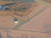
Oak Grove Farm Airport
Official FAA Data Effective 2026-01-22 0901Z
VFR Chart of 5MD4
Sectional Charts at SkyVector.com
IFR Chart of 5MD4
Enroute Charts at SkyVector.com
Location Information for 5MD4
Coordinates: N38°39.39' / W75°43.29'Located 03 miles SE of Federalsburg, Maryland on 40 acres of land. View all Airports in Maryland.
Estimated Elevation is 44 feet MSL.
Operations Data
|
|
Airport Communications
| AWOS-3 at CGE (16.2 SW): | 120.675 410-228-7559 |
|---|---|
| ASOS at GED (16.9 E): | 118.375 302-855-1052 |
| ATIS at ESN (18.5 NW): | 124.475 |
Nearby Navigation Aids
|
| ||||||||||||||||||||||||||||||||||||||||||||||||||||||||||||


Runway 15/33
| Dimensions: | 2100 x 70 feet / 640 x 21 meters | |
|---|---|---|
| Surface: | Turf in Good Condition | |
| Runway 15 | Runway 33 | |
| Coordinates: | N38°39.54' / W75°43.40' | N38°39.24' / W75°43.18' |
| Elevation: | 40.0 | 44.0 |
| Traffic Pattern: | Right | |
| Runway Heading: | 150° True | 330° True |
Ownership Information
| Ownership: | Privately Owned | |
|---|---|---|
| Owner: | RON SOUTHARD | |
| 1760 OAK GROVE RD | ||
| FEDERALSBURG, MD 21632-1818 | ||
| 302-542-1114 | ||
| Manager: | RON SOUTHARD | |
| 1760 OAK GROVE RD | ||
| FEDERALSBURG, MD 21632-1818 | ||
| 302-542-1114 | ||
Other Remarks
- PPR BFR LDNG, AS RWY MAY BE UNUSBL DURG AND AFT HVY RAINFALL.
- FOR CD CTC PATUXENT APCH AT 301-342-3740, WHEN PATUXENT APCH IS CLSD CTC POTOMAC APCH AT 866-640-4124.
- RWY 33 +40 FT PLINES AT THR.
Nearby Airports with Instrument Procedures
| ID | Name | Heading / Distance | ||
|---|---|---|---|---|
 |
N06 | Laurel Airport | 138° | 9.1 |
|
KCGE | Cambridge-Dorchester Regional Airport | 244° | 16.1 |
|
KGED | Delaware Coastal Airport | 083° | 17.1 |
|
KESN | Easton/Newnam Field Airport | 298° | 18.6 |
|
KRJD | Gooden Airpark Airport | 340° | 20.0 |
|
KSBY | Salisbury-Ocean City Wicomico Regional Airport | 152° | 21.4 |
|
KDOV | Dover AFB Airport | 022° | 30.8 |
|
33N | Delaware Airpark Airport | 009° | 34.2 |
|
W29 | Bay Bridge Airport | 304° | 34.4 |
|
KOXB | Ocean City Municipal Airport | 126° | 35.0 |
|
W41 | Crisfield-Somerset County Airport | 187° | 38.6 |
|
KNHK | Patuxent River NAS (Trapnell Field) Airport | 235° | 39.3 |
Airport Images

By: jlshoem
By: jlshoem


