Login
Register


61A
Camden Municipal Airport
Official FAA Data Effective 2026-02-19 0901Z
Chart Supplement

VFR Chart of 61A
Sectional Charts at SkyVector.com
IFR Chart of 61A
Enroute Charts at SkyVector.com
Location Information for 61A
Coordinates: N31°58.78' / W87°20.35'Located 03 miles SW of Camden, Alabama on 77 acres of land. View all Airports in Alabama.
Surveyed Elevation is 142 feet MSL.
Operations Data
|
|
Airport Communications
| CTAF: | 122.900 |
|---|---|
| AWOS-3PT at SEM (28.2 NE): | 119.15 (334) 872-9090 |
| ASOS at GZH (37.1 SE): | 133.425 251-578-1438 |
| ASOS at PRN (38.0 E): | 120.0 334-203-5230 |
- APCH/DEP SVC PRVDD BY ATLANTA ARTCC (ZTL) ON 120.55/270.25 (MONTGOMERY RCAG).
Nearby Navigation Aids
|
| ||||||||||||||||||||||||||||||||||||||||||||||||||||||||||||


Runway 18/36
| Dimensions: | 4303 x 80 feet / 1312 x 24 meters | |
|---|---|---|
| Surface: | Asphalt / Aggregate Friction Seal Coated in Fair Condition RWY SFC TREATMENT HAS FADED/STREAKED THRUT RWY PAVEMENT SFCS. | |
| Weight Limits: | S-27 | |
| Edge Lighting: | Medium Intensity | |
| Runway 18 | Runway 36 | |
| Coordinates: | N31°59.14' / W87°20.35' | N31°58.43' / W87°20.34' |
| Elevation: | 142.7 | 142.3 |
| Traffic Pattern: | Left | Left |
| Runway Heading: | 179° True | 359° True |
| Markings: | Non-Precision Instrument in fair condition. | Non-Precision Instrument in fair condition. |
| Glide Slope Indicator | P2L (3.50° Glide Path Angle) | P2L (3.50° Glide Path Angle) |
| Obstacles: | 9 ft Tree 270 ft from runway, 1 ft right of center | 12 ft Tree 387 ft from runway, 20 ft right of center |
Services Available
| Fuel: | NONE |
|---|---|
| Transient Storage: | Tiedowns |
| Airframe Repair: | NONE |
| Engine Repair: | NONE |
| Bottled Oxygen: | NONE |
| Bulk Oxygen: | NONE |
Ownership Information
| Ownership: | Publicly owned | |
|---|---|---|
| Owner: | CITY OF CAMDEN | |
| 108 WATER STREET | ||
| CAMDEN, AL 36726 | ||
| 334-456-1044 | ||
| Manager: | RALEIGH WILKERSON | |
| 108 WATER STREET | ||
| CAMDEN, AL 36726 | ||
| 334-830-1654 | ||
Other Remarks
- FOR CD CTC ATLANTA ARTCC AT 770-210-7692.
- ACTVT PAPI RWY 18 & 36; MIRL RWY 18/36 - CTAF.
Weather Minimums

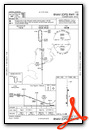
Instrument Approach Procedure (IAP) Charts

Nearby Airports with Instrument Procedures
| ID | Name | Heading / Distance | ||
|---|---|---|---|---|
 |
KSEM | Craig Field Airport | 039° | 28.2 |
|
KMVC | Monroe County Aeroplex Airport | 181° | 31.2 |
|
A08 | Vaiden Field Airport | 355° | 31.9 |
|
KGZH | Evergreen Regional/Middleton Field Airport | 155° | 37.0 |
|
KPRN | Mac Crenshaw Memorial Airport | 101° | 38.1 |
|
09A | Butler/Choctaw County Airport | 281° | 41.1 |
|
4R3 | Jackson Municipal Airport | 223° | 41.7 |
|
KDYA | Demopolis Regional Airport | 312° | 42.7 |
|
7A0 | Greensboro Municipal Airport | 338° | 45.1 |
|
1A9 | Prattville/Grouby Field Airport | 056° | 50.2 |
|
KMGM | Montgomery Regional (Dannelly Field) Airport | 067° | 51.8 |
|
5R1 | Roy Wilcox Airport | 234° | 54.0 |
Airport Images
Do you have a recent image of this airport? Upload it here!


