Login
Register


61C
Fort Atkinson Municipal Airport
Official FAA Data Effective 2025-12-25 0901Z
Chart Supplement

VFR Chart of 61C
Sectional Charts at SkyVector.com
IFR Chart of 61C
Enroute Charts at SkyVector.com
Location Information for 61C
Coordinates: N42°57.79' / W88°49.06'Located 03 miles NE of Fort Atkinson, Wisconsin on 118 acres of land. View all Airports in Wisconsin.
Surveyed Elevation is 800 feet MSL.
Operations Data
|
|
Airport Communications
| MADISON APPROACH: | 120.1 350.3 |
|---|---|
| MADISON DEPARTURE: | 120.1 350.3 |
| CTAF: | 122.900 |
| AWOS-3 at RYV (13.1 N): | 119.975 920-261-0734 |
| AWOS-3PT at 57C (22.3 SE): | 118.125 262-642-1845 |
| AWOS-3 at JVL (22.8 SW): | 608-758-1723 |
- APCH/DEP SVC PRVDD BY CHICAGO ARTCC ON FREQS 133.3/257.925 (LONE ROCK RCAG) WHEN MADISON APCH CTL CLSD.
Nearby Navigation Aids
|
| ||||||||||||||||||||||||||||||||||||||||||||||||||||||


Runway 03/21
| Dimensions: | 3800 x 60 feet / 1158 x 18 meters | |
|---|---|---|
| Surface: | Asphalt in Good Condition | |
| Weight Limits: | S-12 | |
| Edge Lighting: | Medium Intensity | |
| Runway 03 | Runway 21 | |
| Coordinates: | N42°57.52' / W88°49.26' | N42°58.07' / W88°48.86' |
| Elevation: | 798.5 | 795.7 |
| Traffic Pattern: | Left | |
| Runway Heading: | 28° True | 208° True |
| Markings: | Non-Precision Instrument in good condition. | Non-Precision Instrument in good condition. |
| Glide Slope Indicator | P2L (3.00° Glide Path Angle) | P2L (3.00° Glide Path Angle) |
| Obstacles: | 10 FT BRUSH 30 FT FM THR; 100 FT L. |
10 ft Brush 220 ft from runway, 120 ft right of center 10 FT BRUSH 100 FT FM THR; 115 FT R. |
Services Available
| Fuel: | 100LL (blue), Jet A+ |
|---|---|
| Transient Storage: | Tiedowns |
| Airframe Repair: | NONE |
| Engine Repair: | NONE |
| Bottled Oxygen: | NONE |
| Bulk Oxygen: | NONE |
| Other Services: | PARACHUTE JUMP ACTIVITY |
Ownership Information
| Ownership: | Publicly owned | |
|---|---|---|
| Owner: | CITY OF FT. ATKINSON | |
| 101 NORTH MAIN ST | ||
| FORT ATKINSON, WI 53538 | ||
| 920-397-9901 | ||
| Manager: | JEDIDIAH DRAEGER | |
| 101 N MAIN ST | EMAIL ADDRESS: JDRAEGER@FORTATKINSONWI.GOV | |
| FORT ATKINSON, WI 53538 | ||
| 920-397-9901 | ||
Other Remarks
- RY 03/21 PILOTS REQUESTED TO FLY RY HEADING & CLIMB TO 1400 FT MSL BEFORE TURNING EAST.
- ULTRALIGHT ACTVTY ON & IN VCNTY OF ARPT.
- FOR CD CTC MADISON APP/DEP CON AT 608-249-8240. WHEN MADISON APCH CLSD, FOR CD CTC CHICAGO ARTCC AT 630-906-8921.
- 0LL 24 HR SELF SVC FUEL AVBL WITH CREDIT CARD.
- MIRL RWY 03/21 PRESET TO LOW SS-SR; TO INCR INTST & ACTVT PAPI RWY 03 & 21; MIRL RWY 03/21 - CTAF.
Weather Minimums
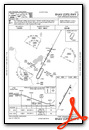
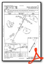
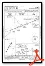
Instrument Approach Procedure (IAP) Charts
Nearby Airports with Instrument Procedures
| ID | Name | Heading / Distance | ||
|---|---|---|---|---|
 |
KRYV | Watertown Municipal Airport | 018° | 13.1 |
|
87Y | Blackhawk Airfield Airport | 297° | 18.3 |
|
57C | East Troy Municipal Airport | 116° | 22.0 |
|
KJVL | Southern Wisconsin Regional Airport | 205° | 22.8 |
|
KMSN | Dane County Regional/Truax Field Airport | 295° | 25.2 |
|
KUES | Waukesha County Airport | 079° | 26.0 |
|
KBUU | Burlington Municipal Airport | 125° | 27.9 |
|
KUNU | Dodge County Airport | 010° | 28.2 |
|
44C | Beloit Airport | 193° | 28.7 |
|
KHXF | Hartford Municipal Airport | 038° | 29.8 |
|
C29 | Middleton Municipal/Morey Field Airport | 286° | 32.7 |
|
KMWC | Lawrence J Timmerman Airport | 075° | 35.6 |
Airport Images
Do you have a recent image of this airport? Upload it here!


