Login
Register


BUU
Burlington Municipal Airport
Official FAA Data Effective 2026-01-22 0901Z
Chart Supplement

VFR Chart of KBUU
Sectional Charts at SkyVector.com
IFR Chart of KBUU
Enroute Charts at SkyVector.com
Location Information for KBUU
Coordinates: N42°41.44' / W88°18.28'Located 01 miles NW of Burlington, Wisconsin on 240 acres of land. View all Airports in Wisconsin.
Surveyed Elevation is 780 feet MSL.
Operations Data
|
|
Airport Communications
| AWOS-3: | 125.275 Tel. 262-757-0907 |
|---|---|
| MILWAUKEE APPROACH: | 135.875 307.0 |
| MILWAUKEE DEPARTURE: | 135.875 307.0 |
| GOPAC STAR: | 126.5 307.0 |
| CTAF: | 123.050 |
| UNICOM: | 123.050 |
| AWOS-3PT at 57C (6.9 N): | 118.125 262-642-1845 |
| ASOS at ENW (17.2 E): | 262-652-7730 |
| ATIS at ENW (17.6 E): | 127.175 |
Nearby Navigation Aids
|
| ||||||||||||||||||||||||||||||||||||||||||||||||


Runway 11/29
| Dimensions: | 4300 x 75 feet / 1311 x 23 meters | |
|---|---|---|
| Surface: | Asphalt in Good Condition | |
| Weight Limits: | S-20 | |
| Edge Lighting: | Medium Intensity | |
| Runway 11 | Runway 29 | |
| Coordinates: | N42°41.61' / W88°18.77' | N42°41.38' / W88°17.86' |
| Elevation: | 777.4 | 775.7 |
| Traffic Pattern: | Left | Right |
| Runway Heading: | 109° True | 289° True |
| Markings: | Non-Precision Instrument in fair condition. | Non-Precision Instrument in fair condition. |
| Glide Slope Indicator | P2L (3.50° Glide Path Angle) | P2L (3.25° Glide Path Angle) |
| REIL: | Yes | Yes |
Runway 01/19
| Dimensions: | 2410 x 130 feet / 735 x 40 meters | |
|---|---|---|
| Surface: | Turf in Good Condition | |
| Runway 01 | Runway 19 | |
| Coordinates: | N42°41.15' / W88°18.28' | N42°41.54' / W88°18.17' |
| Elevation: | 772.9 | 775.1 |
| Traffic Pattern: | Left | Right |
| Runway Heading: | 12° True | 192° True |
Services Available
| Fuel: | 100LL (blue), Jet A+ |
|---|---|
| Transient Storage: | Hangars,Tiedowns |
| Airframe Repair: | MAJOR |
| Engine Repair: | MAJOR |
| Bottled Oxygen: | LOW |
| Bulk Oxygen: | NONE |
| Other Services: | PILOT INSTRUCTION,AIRCRAFT RENTAL,AIRCRAFT SALES |
Ownership Information
| Ownership: | Publicly owned | |
|---|---|---|
| Owner: | CITY OF BURLINGTON | |
| CITY HALL 300 N PINE | ||
| BURLINGTON, WI 53105 | ||
| 262-763-3717 | ||
| Manager: | PAUL AYDT | |
| 707 AIRPORT DRIVE | EMAIL ADDRESS: PAYDT@BURLINGTON-WI.GOV. | |
| BURLINGTON, WI 53105 | ||
| 262-342-5003 | ||
Other Remarks
- ASPH TWY 30 FT WIDE, EXCEPT 'W' 700 FT 35 FT WIDE.
- DEPARTING TFC CLIMB TO 1000 FT AGL BEFORE TURNING SOUTH.
- WATERFOWL ON & INVOF ARPT.
- TFC DEPARTING RY 11 AVOID OVERFLIGHT OF CITY.
- GCO AVBL ON FREQ 121.725 THRU FLT SVCS.
- FOR CD CTC CHICAGO ARTCC AT 630-906-8921.
- MKD WITH YELLOW/BLACK WOODEN PANELS.
- MKD WITH YELLOW/BLACK WOODEN PANELS.
- 0LL 24 HR SELF SVC FUEL AVBL WITH CREDIT CARD.
- MIRL RWY 11/29 PRESET TO LOW SS-SR; TO INCR INTST & ACTVT REIL RWY 11 & 29; MIRL RWY 11/29 - CTAF. PAPI RWY 11 & 29 OPR CONSLY.
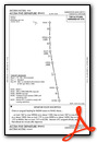
Weather Minimums


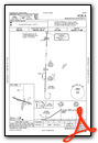
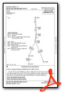
Standard Terminal Arrival (STAR) Charts

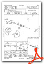
Instrument Approach Procedure (IAP) Charts
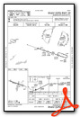
Departure Procedure (DP) Charts
Nearby Airports with Instrument Procedures
| ID | Name | Heading / Distance | ||
|---|---|---|---|---|
 |
57C | East Troy Municipal Airport | 334° | 7.1 |
|
10C | Galt Field Airport | 190° | 17.5 |
|
KENW | Kenosha Regional Airport | 108° | 17.6 |
|
KUES | Waukesha County Airport | 008° | 21.2 |
|
KRAC | Batten International Airport | 078° | 22.1 |
|
KMKE | General Mitchell International Airport | 049° | 23.7 |
|
C81 | Campbell Airport | 154° | 24.2 |
|
KUGN | Waukegan Ntl Airport | 129° | 25.2 |
|
KMWC | Lawrence J Timmerman Airport | 025° | 27.9 |
|
61C | Fort Atkinson Municipal Airport | 305° | 27.9 |
|
3CK | Lake In The Hills Airport | 181° | 29.0 |
|
44C | Beloit Airport | 248° | 31.6 |
Airport Images
 Municipal Airport KBUU from ~1nm W of Rwy 11")
By: 2flaps
 Municipal Airport KBUU from 2nm E, N of Echo Lake")
By: 2flaps


