Login
Register
61D
Virgil L Williams Plainwell Municipal Airport
Official FAA Data Effective 2026-01-22 0901Z
VFR Chart of 61D
Sectional Charts at SkyVector.com
IFR Chart of 61D
Enroute Charts at SkyVector.com
Location Information for 61D
Coordinates: N42°28.07' / W85°38.88'Located 02 miles N of Plainwell, Michigan on 80 acres of land. View all Airports in Michigan.
Estimated Elevation is 722 feet MSL.
Operations Data
|
|
Airport Communications
| CTAF: | 122.800 |
|---|---|
| UNICOM: | 122.800 |
| ATIS at AZO (14.7 S): | 127.25 |
| ASOS at AZO (15.1 S): | 269-459-3391 |
| ATIS at BTL (20.1 SE): | 128.325 |
Nearby Navigation Aids
|
| ||||||||||||||||||||||||||||||||||||||||||||||||||||||||||||
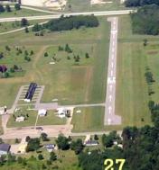
Runway 09/27
| Dimensions: | 2650 x 50 feet / 808 x 15 meters | |
|---|---|---|
| Surface: | Asphalt in Poor Condition EXTSV CRACKING & RAVELING. | |
| Edge Lighting: | Low Intensity | |
| Runway 09 | Runway 27 | |
| Coordinates: | N42°28.05' / W85°39.12' | N42°28.05' / W85°38.53' |
| Elevation: | 721.1 | 721.2 |
| Traffic Pattern: | Left | Left |
| Runway Heading: | 89° True | 269° True |
| Displaced Threshold: | 381 Feet | 395 Feet |
| Markings: | Basic in fair condition. | Basic in fair condition. |
| Obstacles: | 17 ft Road 200 ft from runway, 125 ft right of center APCH SLP 6:1 TO DTHR OVR 35 FT TREE, 240 FT DIST, 130 FT R. 4 FT FENCE, 50 FT DIST; 17 FT ROAD, 140 FT DIST. |
55 ft Trees 201 ft from runway APCH SLP 7:1 TO DTHR OVR 13 FT TREE, 100 FT DIST, 130 FT R. 6 FT FENCE, 62 FT DIST; 15 FT ROAD, 100 FT DIST; 55 FT TREE, 155 FT DIST. |
Runway 01/19
| Dimensions: | 2550 x 100 feet / 777 x 30 meters | |
|---|---|---|
| Surface: | Turf in Good Condition | |
| Runway 01 | Runway 19 | |
| Coordinates: | N42°27.88' / W85°38.97' | N42°28.29' / W85°38.90' |
| Elevation: | 722.0 | 722.0 |
| Traffic Pattern: | Left | Left |
| Runway Heading: | 7° True | 187° True |
| Displaced Threshold: | 400 Feet | |
| Obstacles: | 15 ft Road 20 ft from runway, 50 ft right of center APCH SLP 19:1 TO DTHR OVR 60 FT TREE, 1150 FT DIST, 10 FT L. |
74 ft Trees 120 ft from runway, 50 ft right of center APCH SLP 14:1 TO DTHR OVR 60 FT TREE, 854 FT DIST, 110 FT R. |
Services Available
| Fuel: | 100LL (blue) |
|---|---|
| Transient Storage: | Tiedowns |
| Airframe Repair: | MAJOR |
| Engine Repair: | MAJOR |
| Bottled Oxygen: | NONE |
| Bulk Oxygen: | NONE |
| Other Services: | PILOT INSTRUCTION |
Ownership Information
| Ownership: | Publicly owned | |
|---|---|---|
| Owner: | CITY OF PLAINWELL | |
| 211 N MAIN ST | ||
| PLAINWELL, MI 49080-1370 | ||
| 269-685-6821 | ||
| Manager: | VIRGIL WILLIAMS | |
| 132 COUNTRY CLUB BLVD | ||
| PLAINWELL, MI 49080-9120 | ||
| 269-492-5022 | ||
Other Remarks
- FOR FLD CONDS CALL AMGR.
- FOR CD CTC GREAT LAKES APCH AT 269-459-3344, WHEN APCH CLSD CTC CHICAGO ARTCC AT 630-906-8921.
- RWY 19 DTHR 1350 FT, EXTDS BYD RWY MIDPT.
- RWY & DTHR MKD WITH YELLOW CONES.
- RWY & DTHR MKD WITH YELLOW CONES.
- 0LL SELF SVC.
- ACTVT LIRL RWY 09/27 - 5 CLICKS CTAF.
Nearby Airports with Instrument Procedures
| ID | Name | Heading / Distance | ||
|---|---|---|---|---|
 |
35D | Padgham Field Airport | 295° | 8.7 |
 |
KAZO | Kalamazoo/Battle Creek International Airport | 162° | 14.6 |
 |
9D9 | Hastings Airport | 048° | 17.8 |
 |
KBTL | Battle Creek Exec At Kellogg Field Airport | 118° | 20.2 |
 |
Z98 | Ottawa Exec Airport | 329° | 24.3 |
 |
KGRR | Gerald R Ford International Airport | 012° | 25.4 |
 |
KBIV | West Michigan Regional Airport | 309° | 26.2 |
 |
KLWA | South Haven Area Regional Airport | 255° | 27.9 |
 |
KHAI | Three Rivers Municipal/Dr Haines Airport | 175° | 30.6 |
 |
KRMY | Brooks Field Airport | 112° | 33.4 |
 |
C91 | Dowagiac Municipal Airport | 217° | 35.6 |
 |
KFPK | Fitch H Beach Airport | 079° | 37.6 |


