Login
Register


6VA9
Bush Airport
Official FAA Data Effective 2026-01-22 0901Z
VFR Chart of 6VA9
Sectional Charts at SkyVector.com
IFR Chart of 6VA9
Enroute Charts at SkyVector.com
Location Information for 6VA9
Coordinates: N36°50.56' / W80°14.30'Located 04 miles NE of Woolwine, Virginia. View all Airports in Virginia.
Estimated Elevation is 1500 feet MSL.
Operations Data
|
|
Airport Communications
| AWOS-3 at XQP (12.0 SW): | 119.175 276-952-2902 |
|---|---|
| AWOS-3 at MTV (16.9 SE): | 118.45 276-957-3784 |
| AWOS-3 at BCB (23.5 N): | 133.325 540-231-4837 |
Nearby Navigation Aids
|
| ||||||||||||||||||||||||||||||||||||||||||||||||||||||||||||


Runway 15/33
RWY 15 NOT USABLE FOR LANDING. | ||
| Dimensions: | 2800 x 100 feet / 853 x 30 meters | |
|---|---|---|
| Surface: | Turf | |
| Runway 15 | Runway 33 | |
| Traffic Pattern: | Left | Left |
| Obstacles: | ft Hill 0 ft from runway | ft Trees 50 ft from runway |
Ownership Information
| Ownership: | Privately Owned | |
|---|---|---|
| Owner: | LARRY E. DONLEY | |
| 4461 WOODS GAP RD | ||
| WOOLWINE, VA 24185 | ||
| 276-692-6789 | ||
| Manager: | LARRY E. DONLEY | |
| 4461 WOODS GAP RD | ||
| WOOLWINE, VA 24185 | ||
| 276-930-4311 | ||
Other Remarks
- FOR CD CTC ROANOKE APCH AT 540-563-1307.
Nearby Airports with Instrument Procedures
| ID | Name | Heading / Distance | ||
|---|---|---|---|---|
 |
KMTV | Blue Ridge Airport | 140° | 16.5 |
|
KBCB | Virginia Tech/Montgomery Exec Airport | 339° | 23.5 |
|
KMWK | Mount Airy/Surry County Airport | 213° | 27.4 |
|
KPSK | New River Valley Airport | 309° | 27.6 |
|
KHLX | Twin County Airport | 260° | 28.6 |
|
KSIF | Rockingham County Nc Shiloh Airport | 142° | 30.7 |
|
KROA | Roanoke/Blacksburg Regional (Woodrum Field) Airport | 023° | 31.6 |
|
N63 | Meadow Brook Field Airport | 172° | 32.7 |
|
W91 | Smith Mountain Lake Airport | 062° | 34.9 |
|
KINT | Smith Reynolds Airport | 178° | 42.5 |
|
KZEF | Elkin Municipal Airport | 218° | 42.9 |
|
KDAN | Danville Regional Airport | 110° | 46.4 |
Airport Images
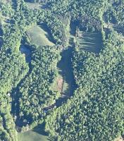
By: Big Orange Bird


