Login
Register


MWK
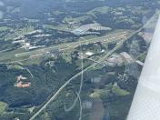
Mount Airy/Surry County Airport
Official FAA Data Effective 2026-02-19 0901Z
Chart Supplement

VFR Chart of KMWK
Sectional Charts at SkyVector.com
IFR Chart of KMWK
Enroute Charts at SkyVector.com
Location Information for KMWK
Coordinates: N36°27.68' / W80°33.19'Located 03 miles SE of Mount Airy, North Carolina on 147 acres of land. View all Airports in North Carolina.
Surveyed Elevation is 1268 feet MSL.
Operations Data
|
|
Airport Communications
| AWOS-3: | 121.125 Tel. 336-789-2299 |
|---|---|
| GREENSBORO APPROACH: | 124.35 269.225 |
| GREENSBORO DEPARTURE: | 124.35 269.225 |
| CTAF: | 123.000 |
| UNICOM: | 123.000 |
| AWOS-3 at XQP (17.2 N): | 119.175 276-952-2902 |
| AWOS-3 at HLX (22.3 NW): | 118.375 276-728-5897 |
| ATIS at INT (25.4 SE): | 121.3 |
Nearby Navigation Aids
|
| ||||||||||||||||||||||||||||||||||||||||||||||||||||||||||||


Runway 18/36
| Dimensions: | 5500 x 75 feet / 1676 x 23 meters | |
|---|---|---|
| Surface: | Asphalt in Excellent Condition | |
| Weight Limits: | 8 /F/B/X/T, S-27, D-42 | |
| Edge Lighting: | Medium Intensity | |
| Runway 18 | Runway 36 | |
| Coordinates: | N36°28.13' / W80°33.26' | N36°27.23' / W80°33.13' |
| Elevation: | 1268.9 | 1208.5 |
| Traffic Pattern: | Left | Left |
| Runway Heading: | 173° True | 353° True |
| Markings: | Non-Precision Instrument in good condition. | Non-Precision Instrument in good condition. |
| Glide Slope Indicator | P4R (3.00° Glide Path Angle) | P4L (3.00° Glide Path Angle) |
| REIL: | Yes | Yes |
| Obstacles: | 47 ft Trees 1219 ft from runway, 275 ft left of center | 63 ft Other 1842 ft from runway, 32 ft left of center |
Services Available
| Fuel: | 100LL (blue), Jet-A, Jet A-1+ |
|---|---|
| Transient Storage: | Hangars,Tiedowns |
| Airframe Repair: | MAJOR |
| Engine Repair: | MAJOR |
| Bottled Oxygen: | NONE |
| Bulk Oxygen: | NONE |
| Other Services: | PILOT INSTRUCTION,AIRCRAFT RENTAL |
Ownership Information
| Ownership: | Publicly owned | |
|---|---|---|
| Owner: | CITY OF MOUNT AIRY & SURRY COUNTY | |
| 146 HOWARD WOLTZ JR. WAY | ||
| MOUNT AIRY, NC 27030-9020 | ||
| 336-401-8201 | ||
| Manager: | GEORGE CRATER | |
| 146 HOWARD WOLTZ JR. WAY | ||
| MOUNT AIRY, NC 27030-9020 | ||
| 336-789-5153 | ||
Other Remarks
- RWY 36 SLOPES UPHILL 34 FEET.
- AFTER HOURS SERVICE AVAILABLE/POSTED ON PHONE BOX.
- RWY 36 - 50 FT DROP-OFF 300 FT FM THR AND 150 FT RIGHT & LEFT OF CNTRLN.
- FOR CD CTC GREENSBORO APCH AT 743-222-6129.
- RWY HAS 100 FT DROP-OFFS 90 FT FM CNTRLN BOTH SIDES AND 300 FT FM THR.
- ACTVT REIL RWY 18 & 36; PAPI RWY 18 & 36; MIRL RWY 18/36 - CTAF.
Weather Minimums

Instrument Approach Procedure (IAP) Charts


Nearby Airports with Instrument Procedures
| ID | Name | Heading / Distance | ||
|---|---|---|---|---|
 |
KZEF | Elkin Municipal Airport | 226° | 15.7 |
|
N63 | Meadow Brook Field Airport | 115° | 21.8 |
|
KHLX | Twin County Airport | 324° | 22.4 |
|
KINT | Smith Reynolds Airport | 140° | 25.4 |
|
KMTV | Blue Ridge Airport | 068° | 27.8 |
|
KUKF | Wilkes County Airport | 241° | 30.0 |
|
8A7 | Twin Lakes Airport | 171° | 33.1 |
|
KSIF | Rockingham County Nc Shiloh Airport | 092° | 34.0 |
|
KGSO | Piedmont Triad International Airport | 125° | 36.7 |
|
KPSK | New River Valley Airport | 351° | 41.0 |
|
KGEV | Ashe County Airport | 267° | 41.9 |
|
KEXX | Davidson County Exec Airport | 163° | 42.5 |