Login
Register
ZEF
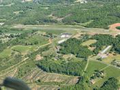
Elkin Municipal Airport
Official FAA Data Effective 2025-12-25 0901Z
VFR Chart of KZEF
Sectional Charts at SkyVector.com
IFR Chart of KZEF
Enroute Charts at SkyVector.com
Location Information for KZEF
Coordinates: N36°16.80' / W80°47.16'Located 03 miles NE of Elkin, North Carolina on 91 acres of land. View all Airports in North Carolina.
Surveyed Elevation is 1067 feet MSL.
MIN ALT 500 FT AGL BASE TURN TO FINAL RWY 25.
Operations Data
|
|
Airport Communications
| CTAF: | 123.050 |
|---|---|
| UNICOM: | 123.050 |
| AWOS-3 at UKF (15.6 W): | 126.625 336-696-3788 |
| AWOS-3 at MWK (15.7 NE): | 121.125 336-789-2299 |
| ATIS at INT (28.7 E): | 121.3 |
- APCH/DEP SVC PRVDD BY ATLANTA ARTCC ON FREQS 125.15/263.0 (HICKORY RCAG).
Nearby Navigation Aids
|
| ||||||||||||||||||||||||||||||||||||||||||||||||||||||||||||
Runway 07/25
| Dimensions: | 4001 x 75 feet / 1220 x 23 meters | |
|---|---|---|
| Surface: | Asphalt in Good Condition | |
| Weight Limits: | S-25 | |
| Edge Lighting: | Medium Intensity | |
| Runway 07 | Runway 25 | |
| Coordinates: | N36°16.67' / W80°47.54' | N36°16.93' / W80°46.79' |
| Elevation: | 1067.0 | 1036.8 |
| Traffic Pattern: | Left | Left |
| Runway Heading: | 67° True | 247° True |
| Markings: | Non-Precision Instrument in good condition. | Non-Precision Instrument in good condition. |
| Glide Slope Indicator | P2L (3.00° Glide Path Angle) UNUSBL 7 DEG LEFT AND RIGHT OF RCL. | P2L (3.00° Glide Path Angle) UNUSBL 9 DEG RIGHT OF RCL. |
| REIL: | Yes | Yes |
| Obstacles: | 26 ft Trees 394 ft from runway, 147 ft right of center | 50 ft Trees 331 ft from runway, 203 ft right of center 56 FT TREES 171 FT FM THR OFFSET 228 FT RIGHT OF CNTRLN. |
Services Available
| Fuel: | 100LL (blue), Jet A-1+ |
|---|---|
| Transient Storage: | Hangars,Tiedowns |
| Airframe Repair: | MAJOR |
| Engine Repair: | MAJOR |
| Bottled Oxygen: | HIGH/LOW |
| Bulk Oxygen: | NONE |
| Other Services: | AIR AMBULANCE SERVICES,PILOT INSTRUCTION |
Ownership Information
| Ownership: | Publicly owned | |
|---|---|---|
| Owner: | TOWN OF ELKIN | |
| TOWN HALL - PO BOX 857 | ||
| ELKIN, NC 28621 | ||
| (336) 794-6464 | ||
| Manager: | STEVE (SANDY) SHORE | |
| 1598 CC CAMP ROAD | ||
| ELKIN, NC 28621 | ||
| 336-366-3433 | ||
Other Remarks
- RWY 07 SAFETY AREA HAS 80+ FT DROP-OFF AT END AND 90 FT BOTH SIDES OF CNTRLN.
- DEER ON AND INVOF ARPT.
- RWY 25 HAS AN UPHILL GRADE.
- FOR SERVICE AFTER HOURS CALL (336)-874-7171, (336)-874-2931, (336)-366-7994, OR (336)-926-6243.
- FOR CD CTC ATLANTA ARTCC AT 770-210-7692.
- RWY 25 HAS UP TO 100+ FT DROP-OFF FIRST 600 FT AND 90 FT BOTH SIDES OF CNTRLN.
- RWY 25 HAS UNMARKED POWER LINES 800 FT FM THR BOTH SIDES OF CNTRLN.
- 0LL 24 HR SELF SERVICE W/ CREDIT CARD.
- ACTVT REIL RWY 07 & 25; PAPI RWY 07 & 25; MIRL RWY 07/25 - CTAF.
- MIN ALT 500 FT AGL BASE TURN TO FINAL RWY 25.
Weather Minimums
Instrument Approach Procedure (IAP) Charts
Nearby Airports with Instrument Procedures
| ID | Name | Heading / Distance | ||
|---|---|---|---|---|
 |
KUKF | Wilkes County Airport | 257° | 15.5 |
 |
KMWK | Mount Airy/Surry County Airport | 046° | 15.7 |
 |
8A7 | Twin Lakes Airport | 143° | 27.1 |
 |
KINT | Smith Reynolds Airport | 107° | 28.8 |
 |
KHLX | Twin County Airport | 356° | 29.2 |
 |
N63 | Meadow Brook Field Airport | 087° | 30.9 |
 |
KGEV | Ashe County Airport | 286° | 32.0 |
 |
KSVH | Statesville Regional Airport | 194° | 31.9 |
 |
KEXX | Davidson County Exec Airport | 141° | 38.0 |
 |
KRUQ | Mid-Carolina Regional Airport | 161° | 40.1 |
 |
14A | Lake Norman Airpark Airport | 187° | 40.3 |
 |
KGSO | Piedmont Triad International Airport | 104° | 42.4 |


