Login
Register


HLX
Twin County Airport
Official FAA Data Effective 2026-01-22 0901Z
Chart Supplement

VFR Chart of KHLX
Sectional Charts at SkyVector.com
IFR Chart of KHLX
Enroute Charts at SkyVector.com
Location Information for KHLX
Coordinates: N36°45.96' / W80°49.41'Located 07 miles NE of Galax Hillsville, Virginia on 140 acres of land. View all Airports in Virginia.
Surveyed Elevation is 2693 feet MSL.
Operations Data
|
|
Airport Communications
| AWOS-3: | 118.375 Tel. 276-728-5897 |
|---|---|
| ROANOKE APPROACH: | 126.0 339.8 |
| ROANOKE DEPARTURE: | 126.0 339.8 |
| IC: | 126.0 339.8 |
| UNICOM: | 122.800 |
| CTAF: | 122.800 |
| AWOS-3 at XQP (18.1 E): | 119.175 276-952-2902 |
| AWOS-3 at MWK (22.5 SE): | 121.125 336-789-2299 |
| AWOS-3 at PSK (23.1 N): | 127.375 540-674-2731 |
Nearby Navigation Aids
|
| ||||||||||||||||||||||||||||||||||||||||||||||||||||||||||||


Runway 01/19
| Dimensions: | 4151 x 75 feet / 1265 x 23 meters | |
|---|---|---|
| Surface: | Asphalt in Fair Condition | |
| Weight Limits: | S-12 | |
| Edge Lighting: | Medium Intensity | |
| Runway 01 | Runway 19 | |
| Coordinates: | N36°45.62' / W80°49.40' | N36°46.30' / W80°49.42' |
| Elevation: | 2693.1 | 2642.6 |
| Traffic Pattern: | Left | Left |
| Runway Heading: | 359° True | 179° True |
| Markings: | Non-Precision Instrument in good condition. | Non-Precision Instrument in good condition. |
| Glide Slope Indicator | P2L (3.00° Glide Path Angle) | P2L (3.00° Glide Path Angle) |
| REIL: | Yes | Yes |
| Obstacles: | 41 ft Trees 985 ft from runway, 355 ft left of center RWY 01 HAS 10-20 FT HILL LCTD 150 FT W OF RWY 01, BEGINNING N OF THLD. |
54 ft Trees 1237 ft from runway, 63 ft right of center |
Services Available
| Fuel: | 100LL (blue), Jet A+ |
|---|---|
| Transient Storage: | Tiedowns |
| Airframe Repair: | MAJOR |
| Engine Repair: | MAJOR |
| Bottled Oxygen: | NONE |
| Bulk Oxygen: | NONE |
| Other Services: | PILOT INSTRUCTION,AIRCRAFT RENTAL |
Ownership Information
| Ownership: | Publicly owned | |
|---|---|---|
| Owner: | TWIN COUNTY ARPT COMSN | |
| 504 HANGAR RD. | ||
| HILLSVILLE, VA 24343-5264 | ||
| 276-728-4504 | FAX 276-728-4544. | |
| Manager: | MICHAEL LAWSON | |
| 504 HANGAR RD. | ||
| HILLSVILLE, VA 24343-5264 | ||
| 276-728-4504 | ||
Other Remarks
- DEER ON & INVOF ARPT.
- RWY 01 10-20 FT HILL LCTD 150 FT W OF RWY 01 BEGINNING N OF THLD.
- ROA TWR SVCS AVBL AT 540-563-1307.
- FOR CD CTC ROANOKE APCH AT 540-563-1307.
- AFT HRS TRML ACCESS AVBL S SIDE OF BLDG.
- UNATNDD NEW YEAR'S DAY, EASTER, THANKSGIVING, & CHRISTMAS.
- RWY MRKG CONDS VARY BTWN GOOD & FAIR. RWY DISPLACEMENT MRKG INCORRECT.
- 0LL SELF-SVC FUEL AVLB 24 HRS WITH CREDIT CARD.
- ACTVT MIRL RWY 1/19 - CTAF. REILS RWY 1 & 19; PAPI RWY 1 & 19 OPS CONSLY.
Weather Minimums

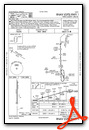
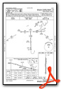
Instrument Approach Procedure (IAP) Charts
Nearby Airports with Instrument Procedures
| ID | Name | Heading / Distance | ||
|---|---|---|---|---|
 |
KMWK | Mount Airy/Surry County Airport | 144° | 22.4 |
|
KPSK | New River Valley Airport | 017° | 23.3 |
|
KMKJ | Mountain Empire Airport | 287° | 26.5 |
|
KZEF | Elkin Municipal Airport | 176° | 29.2 |
|
KBCB | Virginia Tech/Montgomery Exec Airport | 036° | 33.1 |
|
KGEV | Ashe County Airport | 235° | 35.0 |
|
KUKF | Wilkes County Airport | 202° | 35.1 |
|
KBLF | Mercer County Airport | 329° | 36.7 |
|
KMTV | Blue Ridge Airport | 101° | 39.7 |
|
N63 | Meadow Brook Field Airport | 130° | 42.8 |
|
KINT | Smith Reynolds Airport | 142° | 47.8 |
|
KJFZ | Tazewell County Airport | 291° | 50.2 |
Airport Images
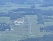
By: Big Orange Bird


Comments
New Terminal Facility
Come on out and see our brand new terminal building. Complete with pilots lounge, flight planning room, passenger lobby, and conference room.