Login
Register


76F
Van Zandt County Regional Airport
Official FAA Data Effective 2026-02-19 0901Z
Chart Supplement

VFR Chart of 76F
Sectional Charts at SkyVector.com
IFR Chart of 76F
Enroute Charts at SkyVector.com
Location Information for 76F
Coordinates: N32°40.89' / W95°59.05'Located 03 miles SE of Wills Point, Texas on 78 acres of land. View all Airports in Texas.
Surveyed Elevation is 522 feet MSL.
Operations Data
|
|
Airport Communications
| UNICOM: | 122.725 |
|---|---|
| CTAF: | 122.725 |
| ASOS at TRL (14.5 W): | 119.275 972-551-1334 |
| AWOS-3 at GVT (23.6 N): | 133.425 903-455-7703 |
| AWOS-3 at JDD (25.0 E): | 118.9 903-768-3065 |
Nearby Navigation Aids
|
| ||||||||||||||||||||||||||||||||||||||||||||||||||||||||||||


Runway 17/35
| Dimensions: | 3230 x 50 feet / 985 x 15 meters | |
|---|---|---|
| Surface: | Asphalt in Fair Condition | |
| Weight Limits: | S-12 | |
| Edge Lighting: | Low Intensity | |
| Runway 17 | Runway 35 | |
| Coordinates: | N32°41.15' / W95°59.05' | N32°40.62' / W95°59.05' |
| Elevation: | 522.0 | 502.0 |
| Traffic Pattern: | Left | |
| Runway Heading: | 180° True | 360° True |
| Markings: | Basic in fair condition. | Basic in fair condition. |
| Obstacles: | 38 ft Tree 900 ft from runway, 165 ft left of center | 22 ft Trees 425 ft from runway, 125 ft right of center |
Services Available
| Fuel: | 100LL (blue) |
|---|---|
| Transient Storage: | Tiedowns |
| Airframe Repair: | MINOR |
| Engine Repair: | MINOR |
| Bottled Oxygen: | NONE |
| Bulk Oxygen: | NONE |
Ownership Information
| Ownership: | Publicly owned | |
|---|---|---|
| Owner: | CITY OF WILLS POINT | |
| 518 HOUSTON STREET, PO BOX 505 | ||
| WILLS POINT, TX 75169 | ||
| 903-873-2578 | ||
| Manager: | PAM PEARSON | WILLS POINT EDC |
| PO BOX 217 | ARPT PHYSICAL ADDRESS: 36671 STATE HWY 64. | |
| WILLS POINT, TX 75169 | ||
| 903-873-3381 | ||
Other Remarks
- 68 FT ANTENNA 810 FT EAST OF RWY CNTRLN.
- FOR CD CTC FORT WORTH ARTCC AT 817-858-7584.
- 24 HR PILOT ACES TO LOUNGE.
- 0LL SELF SERVE 24 HRS.
Nearby Airports with Instrument Procedures
| ID | Name | Heading / Distance | ||
|---|---|---|---|---|
 |
KTRL | Terrell Municipal Airport | 276° | 14.4 |
|
KGVT | Majors Airport | 349° | 23.5 |
|
KJDD | Wood County/Collins Field Airport | 081° | 25.0 |
|
7F3 | Caddo Mills Municipal Airport | 328° | 25.0 |
|
F46 | Ralph M Hall/Rockwall Municipal Airport | 303° | 27.3 |
|
KHQZ | Mesquite Metro Airport | 278° | 27.9 |
|
F44 | Athens Municipal Airport | 165° | 32.0 |
|
KSLR | Sulphur Springs Municipal Airport | 032° | 34.0 |
|
KTYR | Tyler Pounds Regional Airport | 123° | 35.4 |
|
2F7 | Commerce Municipal Airport | 006° | 36.9 |
|
KLNC | Lancaster Regional Airport | 260° | 37.7 |
|
F51 | Winnsboro Municipal Airport | 066° | 38.9 |
Airport Images
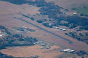
By: SamCom


