Login
Register


SLR
Sulphur Springs Municipal Airport
Official FAA Data Effective 2025-11-27 0901Z
Chart Supplement

VFR Chart of KSLR
Sectional Charts at SkyVector.com
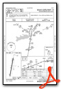
IFR Chart of KSLR
Enroute Charts at SkyVector.com
Location Information for KSLR
Coordinates: N33°9.59' / W95°37.27'Located 02 miles NW of Sulphur Springs, Texas on 350 acres of land. View all Airports in Texas.
Surveyed Elevation is 489 feet MSL.
Operations Data
|
|
Airport Communications
| AWOS-3: | 118.35 Tel. 903-885-9605 |
|---|---|
| CTAF: | 123.075 |
| UNICOM: | 123.075 |
| AWOS-3 at GVT (23.0 W): | 133.425 903-455-7703 |
| AWOS-3 at JDD (26.0 S): | 118.9 903-768-3065 |
| AWOS-3PT at PRX (29.9 N): | 119.675 903-737-8784 |
- APCH/DEP SVC PRVDD BY FORT WORTH ARTCC (ZFW) ON FREQS 132.025/317.75 (CUMBY RCAG).
Nearby Navigation Aids
|
| ||||||||||||||||||||||||||||||||||||||||||||||||||||||||||||


Runway 01/19
| Dimensions: | 5001 x 75 feet / 1524 x 23 meters | |
|---|---|---|
| Surface: | Concrete in Excellent Condition | |
| Weight Limits: | S-30, D-50 | |
| Edge Lighting: | Medium Intensity | |
| Runway 01 | Runway 19 | |
| Coordinates: | N33°9.18' / W95°37.35' | N33°10.00' / W95°37.19' |
| Elevation: | 489.3 | 465.9 |
| Runway Heading: | 10° True | 190° True |
| Markings: | Precision Instrument in good condition. | Precision Instrument in good condition. |
| Glide Slope Indicator | P4L (3.00° Glide Path Angle) | P4L (3.00° Glide Path Angle) PAPI UNUSBL BYD 8 DEGS RIGHT OF RCL. |
| REIL: | Yes | Yes |
| Obstacles: | 5 ft Fence 201 ft from runway, 249 ft left of center 5 FT FENCE 0-199 FT DSTC, 249 FT LEFT. |
10 FT BRUSH, 10 FT DSTC, 132 R. |
Services Available
| Fuel: | 100LL (blue), Jet-A |
|---|---|
| Transient Storage: | Hangars,Tiedowns |
| Airframe Repair: | MAJOR |
| Engine Repair: | MAJOR |
| Bottled Oxygen: | NOT AVAILABLE |
| Bulk Oxygen: | NOT AVAILABLE |
Ownership Information
| Ownership: | Publicly owned | |
|---|---|---|
| Owner: | CITY OF SULPHUR SPRINGS | |
| 125 SOUTH DAVIS ST. | ||
| SULPHUR SPRINGS, TX 75482 | ||
| 903-885-7541 | ||
| Manager: | JOEY BAKER | |
| 1220 CESSNA DR. | ||
| SULPHUR SPRINGS, TX 75482 | ||
| 903-885-4911 | ||
Other Remarks
- THIS AIRPORT HAS BEEN SURVEYED BY THE NATIONAL GEODETIC SURVEY.
- BIRDS ON & INVOF ARPT.
- LGT SPORT ACFT OPRG ON WEST SIDE OF RWY.
- RWY 01 45 FT BLDG 1,820 DSTC.
- FOR CD CTC FORT WORTH ARTCC AT 817-858-7584.
- RWY 1, 44 FT UNMKD PLINE, 1530 FT DSTC, 30:1; 58 FT TANK, 1820 FT DSTC, 30 FT L, 27:1; 125 FT ANTENNA, 1515 FT EAST OF RWY 1 END.
- FOR ATTENDANT ON SUN CALL 903-885-4911 DURG ATTENDED HRS.
- 0LL 100LL AVBL 24 HRS SELF-SERVE.
- MIRL RWY 01/19 PRESET LOW DUSK-DAWN. TO INCR INTST AND ACTVT REIL RWYS 01 & 19 - CTAF. PAPI RWYS 01 & 19 OPR CONSLY.
Weather Minimums

Instrument Approach Procedure (IAP) Charts

Nearby Airports with Instrument Procedures
| ID | Name | Heading / Distance | ||
|---|---|---|---|---|
 |
2F7 | Commerce Municipal Airport | 299° | 16.0 |
|
F53 | Franklin County Airport | 080° | 19.6 |
|
F51 | Winnsboro Municipal Airport | 127° | 21.8 |
|
KGVT | Majors Airport | 256° | 23.1 |
|
KJDD | Wood County/Collins Field Airport | 165° | 25.8 |
|
KPRX | Cox Field Airport | 016° | 29.8 |
|
7F3 | Caddo Mills Municipal Airport | 256° | 32.2 |
|
KOSA | Mount Pleasant Regional Airport | 096° | 33.4 |
|
F00 | Jones Field Airport | 314° | 39.0 |
|
KTRL | Terrell Municipal Airport | 230° | 42.4 |
|
F46 | Ralph M Hall/Rockwall Municipal Airport | 251° | 43.3 |
|
KJXI | Fox Stephens Field/Gilmer Municipal Airport | 128° | 43.8 |
Airport Images
Do you have a recent image of this airport? Upload it here!


