Login
Register


F44
Athens Municipal Airport
Official FAA Data Effective 2026-01-22 0901Z
Chart Supplement

VFR Chart of F44
Sectional Charts at SkyVector.com
IFR Chart of F44
Enroute Charts at SkyVector.com
Location Information for F44
Coordinates: N32°9.83' / W95°49.70'Located 03 miles SE of Athens, Texas on 65 acres of land. View all Airports in Texas.
Surveyed Elevation is 444 feet MSL.
Operations Data
|
|
Airport Communications
| AWOS-3PT: | 119.6 Tel. 903-670-1247 |
|---|---|
| CTAF: | 123.000 |
| UNICOM: | 123.000 |
| AWOS-3PT at PSN (24.0 S): | 118.025 903-729-3641 |
| ATIS at TYR (24.4 NE): | 126.25 |
| ASOS at TYR (24.5 NE): | 903-535-9105 |
- APCH/DEP SVC PRVDD BY FORT WORTH ARTCC (ZFW) ON FREQS 135.25/279.65 (TYLER RCAG).
Nearby Navigation Aids
|
| ||||||||||||||||||||||||||||||||||||||||||||||||||||||||||||


Runway 18/36
| Dimensions: | 3988 x 60 feet / 1216 x 18 meters | |
|---|---|---|
| Surface: | Asphalt in Good Condition | |
| Weight Limits: | S-25 | |
| Edge Lighting: | Medium Intensity | |
| Runway 18 | Runway 36 | |
| Coordinates: | N32°10.16' / W95°49.70' | N32°9.50' / W95°49.70' |
| Elevation: | 438.3 | 436.9 |
| Traffic Pattern: | Left | Right |
| Runway Heading: | 180° True | 360° True |
| Markings: | Non-Precision Instrument in fair condition. | Non-Precision Instrument in fair condition. |
| Glide Slope Indicator | P2L (3.00° Glide Path Angle) | P2L (4.00° Glide Path Angle) |
| Obstacles: | 66 ft Trees 985 ft from runway, 160 ft left of center ALSO 15 FT RD AT 160 DSTC, 235 L, 0:1. 11 FT ROAD 160 FT DSTC, 235 FT L. |
55 ft Trees 700 ft from runway, 305 ft right of center 12-25 FT TREES ON FENCELINE 0-200 FT DSTC, 247 R. |
Services Available
| Fuel: | 100LL (blue), Jet-A |
|---|---|
| Transient Storage: | Hangars,Tiedowns |
| Airframe Repair: | MAJOR |
| Engine Repair: | MAJOR |
| Bottled Oxygen: | HIGH/LOW |
| Bulk Oxygen: | NONE |
| Other Services: | PILOT INSTRUCTION,AIRCRAFT RENTAL,AIRCRAFT SALES |
Ownership Information
| Ownership: | Publicly owned | |
|---|---|---|
| Owner: | CITY OF ATHENS | |
| 508 E. TYLER | ||
| ATHENS, TX 75751 | ||
| 903-675-5131 | ||
| Manager: | SHANNON EASLEY | PUBLIC WORKS DIRECTOR. |
| 508 E. TYLER | ||
| ATHENS, TX 75751 | ||
| 903-675-8036 | ||
Other Remarks
- THIS AIRPORT HAS BEEN SURVEYED BY THE NATIONAL GEODETIC SURVEY.
- FERAL HOGS ON AND INVOF ARPT.
- FOR CD CTC FORT WORTH ARTCC AT 817-858-7584.
Weather Minimums

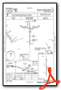
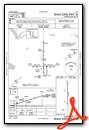
Instrument Approach Procedure (IAP) Charts
Nearby Airports with Instrument Procedures
| ID | Name | Heading / Distance | ||
|---|---|---|---|---|
 |
KPSN | Palestine Municipal Airport | 164° | 23.8 |
|
KTYR | Tyler Pounds Regional Airport | 062° | 24.4 |
|
KCRS | C David Campbell Field-Corsicana Municipal Airport | 254° | 30.3 |
|
KJSO | Cherokee County Airport | 119° | 35.8 |
|
KJDD | Wood County/Collins Field Airport | 025° | 38.5 |
|
KTRL | Terrell Municipal Airport | 325° | 39.5 |
|
F41 | Ennis Municipal Airport | 283° | 43.7 |
|
KLXY | Mexia-Limestone County Airport | 228° | 47.0 |
|
07F | Gladewater Municipal Airport | 063° | 48.7 |
|
KRFI | Rusk County Airport | 091° | 49.8 |
|
KHQZ | Mesquite Metro Airport | 314° | 49.9 |
|
KLNC | Lancaster Regional Airport | 298° | 51.5 |
Airport Images

By: Bandco

By: jahangiriali


