Login
Register


77F
Winters Municipal Airport
Official FAA Data Effective 2025-11-27 0901Z
Chart Supplement

VFR Chart of 77F
Sectional Charts at SkyVector.com
IFR Chart of 77F
Enroute Charts at SkyVector.com
Location Information for 77F
Coordinates: N31°56.83' / W99°59.15'Located 02 miles SW of Winters, Texas on 48 acres of land. View all Airports in Texas.
Surveyed Elevation is 1871 feet MSL.
Operations Data
|
|
Airport Communications
| ABILENE APPROACH: | 127.2 282.3 |
|---|---|
| ABILENE DEPARTURE: | 127.2 282.3 |
| CTAF: | 122.900 |
| ASOS at DYS (29.0 N): | 269.175 |
| ATIS at DYS (29.0 N): | 269.175 |
| AWOS-3PT at COM (30.2 E): | 119.1 325-625-3563 |
Nearby Navigation Aids
|
| ||||||||||||||||||||||||||||||||||||||||||||||||


Runway 18/36
| Dimensions: | 3204 x 50 feet / 977 x 15 meters | |
|---|---|---|
| Surface: | Asphalt in Excellent Condition | |
| Weight Limits: | S-12 | |
| Edge Lighting: | Low Intensity | |
| Runway 18 | Runway 36 | |
| Coordinates: | N31°57.10' / W99°59.15' | N31°56.57' / W99°59.15' |
| Elevation: | 1865.5 | 1871.0 |
| Traffic Pattern: | Left | Left |
| Runway Heading: | 180° True | 0 |
| Markings: | Non-Precision Instrument in good condition. | Non-Precision Instrument in good condition. |
| Obstacles: | 5 ft Fence 201 ft from runway, 160 ft right of center 5 FT FENCE, 0-199 FT DSTC, 160-196 FT R. |
4 ft Fence 201 ft from runway, 180 ft right of center 4 FT FENCE 0-199 FT DSTC-196 FT R. |
Services Available
| Fuel: | NONE |
|---|---|
| Transient Storage: | Tiedowns |
| Airframe Repair: | NOT AVAILABLE |
| Engine Repair: | NOT AVAILABLE |
| Bottled Oxygen: | NOT AVAILABLE |
| Bulk Oxygen: | NOT AVAILABLE |
| Other Services: | CROP DUSTING SERVICES |
Ownership Information
| Ownership: | Publicly owned | |
|---|---|---|
| Owner: | CITY OF WINTERS | |
| 310 S MAIN | ||
| WINTERS, TX 79567 | ||
| 325-754-4424 | ||
| Manager: | RICHARD HUMPHREYS | |
| 129 AVENIDA CORTEZ | ||
| ABILENE, TX 79602 | ||
| 325-665-4200 | ||
Other Remarks
- THIS AIRPORT HAS BEEN SURVEYED BY THE NATIONAL GEODETIC SURVEY.
- 4 FT FENCE 16-200 FT WEST OF RWY.
- PARL TXY FM RAMP SOUTH, GRAVEL WITH POTHOLES, UNUSBL.
- FOR CD CTC FORT WORTH ARTCC AT 817-858-7584.
Weather Minimums
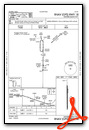
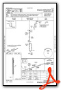
Instrument Approach Procedure (IAP) Charts
Nearby Airports with Instrument Procedures
| ID | Name | Heading / Distance | ||
|---|---|---|---|---|
 |
E30 | Bruce Field Airport | 178° | 16.3 |
|
KDYS | Dyess AFB Airport | 013° | 29.0 |
|
KCOM | Coleman Municipal Airport | 101° | 30.4 |
|
KABI | Abilene Regional Airport | 029° | 31.8 |
|
KSWW | Avenger Field Airport | 321° | 39.6 |
|
KSJT | San Angelo Regional/Mathis Field Airport | 216° | 43.9 |
|
KBWD | Brownwood Regional Airport | 099° | 53.4 |
|
KGZN | Gregory M Simmons Memorial Airport | 062° | 55.0 |
|
KBBD | Curtis Field Airport | 143° | 57.1 |
|
T23 | Albany Municipal Airport | 038° | 59.0 |
|
F56 | Arledge Field Airport | 012° | 59.1 |
|
KETN | Eastland Municipal Airport | 064° | 66.1 |
Airport Images
Do you have a recent image of this airport? Upload it here!


