Login
Register


BWD
Brownwood Regional Airport
Official FAA Data Effective 2025-11-27 0901Z
Chart Supplement

VFR Chart of KBWD
Sectional Charts at SkyVector.com
IFR Chart of KBWD
Enroute Charts at SkyVector.com
Location Information for KBWD
Coordinates: N31°47.62' / W98°57.39'Located 05 miles N of Brownwood, Texas on 1497 acres of land. View all Airports in Texas.
Surveyed Elevation is 1386 feet MSL.
Operations Data
|
|
Airport Communications
| AWOS-3: | 118.325 Tel. 888-297-9399 |
|---|---|
| CTAF: | 122.800 |
| UNICOM: | 122.800 |
| AWOS-3 at MKN (19.9 NE): | 118.575 325-356-7032 |
| AWOS-3PT at COM (23.1 W): | 119.1 325-625-3563 |
| AWOS-4 at GZN (34.7 N): | 118.0 254-442-1185 |
- APCH/DEP CTL SVC PRVDD BY FORT WORTH ARTCC (ZFW) ON FREQS 127.45/290.3 (BROWNWOOD RCAG).
Nearby Navigation Aids
|
| ||||||||||||||||||||||||||||||||||||||||||||||||||||||||||||


Runway 17/35
| Dimensions: | 5599 x 100 feet / 1707 x 30 meters | |
|---|---|---|
| Surface: | Asphalt in Good Condition | |
| Weight Limits: | S-30 | |
| Edge Lighting: | Medium Intensity | |
| Runway 17 | Runway 35 | |
| Coordinates: | N31°48.11' / W98°57.30' | N31°47.19' / W98°57.29' |
| Elevation: | 1384.4 | 1370.1 |
| Traffic Pattern: | Left | Left |
| Runway Heading: | 179° True | 359° True |
| Markings: | Non-Precision Instrument in good condition. | Non-Precision Instrument in good condition. |
| Glide Slope Indicator | P4L (3.00° Glide Path Angle) | P4L (3.00° Glide Path Angle) |
| Approach Lights: | MALS 1,400 Foot Medium-intensity Approach Lighting System. | |
| Obstacles: | 33 ft Trees 1185 ft from runway, 290 ft left of center | 27 ft Trees 1100 ft from runway |
Runway 13/31
| Dimensions: | 4608 x 101 feet / 1405 x 31 meters | |
|---|---|---|
| Surface: | Asphalt in Good Condition | |
| Weight Limits: | S-25 | |
| Edge Lighting: | Medium Intensity | |
| Runway 13 | Runway 31 | |
| Coordinates: | N31°47.84' / W98°57.82' | N31°47.31' / W98°57.18' |
| Elevation: | 1380.8 | 1372.1 |
| Traffic Pattern: | Left | Left |
| Runway Heading: | 134° True | 314° True |
| Markings: | Basic in good condition. | Basic in good condition. |
| Obstacles: | 52 ft Trees 1450 ft from runway, 250 ft left of center | |
Services Available
| Fuel: | 100LL (blue), Jet-A |
|---|---|
| Transient Storage: | Hangars,Tiedowns |
| Airframe Repair: | MAJOR REPAIRS 325-643-1482 |
| Engine Repair: | MAJOR |
| Bottled Oxygen: | NOT AVAILABLE |
| Bulk Oxygen: | NOT AVAILABLE |
| Other Services: | AIR FREIGHT SERVICES,CARGO HANDLING SERVICES,PILOT INSTRUCTION |
Ownership Information
| Ownership: | Publicly owned | |
|---|---|---|
| Owner: | CITY OF BROWNWOOD | |
| BOX 1389 | ||
| BROWNWOOD, TX 76801 | ||
| 325-646-5775 | ||
| Manager: | KYLE WHITLEY | |
| BOX 1389 | ||
| BROWNWOOD, TX 76801 | ||
| 325-643-1482 | ||
Other Remarks
- FOR CD IF UNA TO CTC ON FSS FREQ, CTC FORT WORTH ARTCC AT 817-858-7584.
- 0LL FUEL 24 HRS SELF SVC. FOR FUEL SVC WHEN UNATNDD CALL 325-643-1482.
- ACTVT MALS RWY 17; MIRL RWY 13/31 & 17/35 - CTAF.
Weather Minimums

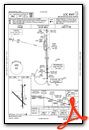
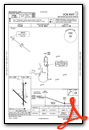
Instrument Approach Procedure (IAP) Charts


Nearby Airports with Instrument Procedures
| ID | Name | Heading / Distance | ||
|---|---|---|---|---|
 |
KMKN | Comanche County-City Airport | 067° | 19.8 |
|
KCOM | Coleman Municipal Airport | 277° | 23.0 |
|
KGZN | Gregory M Simmons Memorial Airport | 354° | 34.4 |
|
81R | San Saba County Municipal Airport | 159° | 35.6 |
|
KETN | Eastland Municipal Airport | 011° | 37.9 |
|
KBBD | Curtis Field Airport | 207° | 41.3 |
|
KMNZ | Hamilton Municipal Airport | 100° | 42.0 |
|
KSEP | Stephenville Clark Regional Airport | 057° | 47.1 |
|
KABI | Abilene Regional Airport | 315° | 52.3 |
|
E30 | Bruce Field Airport | 262° | 52.7 |
|
77F | Winters Municipal Airport | 280° | 53.4 |
|
KBKD | Stephens County Airport | 003° | 55.5 |
Airport Images
Do you have a recent image of this airport? Upload it here!


