Login
Register


7S0
Ronan Airport
Official FAA Data Effective 2026-01-22 0901Z
Chart Supplement

VFR Chart of 7S0
Sectional Charts at SkyVector.com
IFR Chart of 7S0
Enroute Charts at SkyVector.com
Location Information for 7S0
Coordinates: N47°34.03' / W114°6.06'Located 03 miles N of Ronan, Montana on 125 acres of land. View all Airports in Montana.
Surveyed Elevation is 3086 feet MSL.
Operations Data
|
|
Airport Communications
| AWOS-3: | 119.925 Tel. 406-676-2967 |
|---|---|
| UNICOM: | 122.800 |
| CTAF: | 122.800 |
| AWOS-3PT at S34 (32.9 W): | 118.1 406-826-5784 |
| ATIS at MSO (39.1 S): | 126.65 |
| ASOS at MSO (39.1 S): | 406-213-9541 |
- APCH/DEP CTL SVC PRVDD BY SALT LAKE CITY ARTCC (ZLC) ON FREQS 127.075/244.875 (LAKESIDE RCAG).
Nearby Navigation Aids
|
| ||||||||||||||||||||||||||||||||||||||||||


Runway 16/34
| Dimensions: | 4798 x 75 feet / 1462 x 23 meters | |
|---|---|---|
| Surface: | Asphalt in Good Condition | |
| Edge Lighting: | Medium Intensity | |
| Runway 16 | Runway 34 | |
| Coordinates: | N47°34.43' / W114°6.06' | N47°33.64' / W114°6.06' |
| Elevation: | 3086.0 | 3079.4 |
| Runway Heading: | 180° True | 360° True |
| Markings: | Non-Precision Instrument in good condition. | Non-Precision Instrument in good condition. |
| Glide Slope Indicator | P2L (3.00° Glide Path Angle) | P2L (3.00° Glide Path Angle) |
Services Available
| Fuel: | 100LL (blue), Jet A+ |
|---|---|
| Transient Storage: | Tiedowns |
| Airframe Repair: | NONE |
| Engine Repair: | NONE |
| Bottled Oxygen: | NONE |
| Bulk Oxygen: | NONE |
| Other Services: | CROP DUSTING SERVICES,AIR AMBULANCE SERVICES,PILOT INSTRUCTION,PARACHUTE JUMP ACTIVITY |
Ownership Information
| Ownership: | Publicly owned | |
|---|---|---|
| Owner: | CITY OF RONAN AND LAKE CO | |
| 106 4TH AVE EAST | ||
| POLSON, MT 59860 | ||
| 406-249-1683 | ||
| Manager: | BOB SNYDER | |
| 36078 CANON MILL ROAD | ||
| RONAN, MT 59864 | ||
| (406) 250-4824 | ||
Other Remarks
- TWY MKD BY REFLECTORS.
- USE 1215 FOR PILOT LOUNGE
- FOR CD CTC SALT LAKE ARTCC AT 801-320-2568.
- ACTVT PAPI RWY 16 & 34; MIRL RWY 16/34 - CTAF.
- AUTOMATED UNICOM.
Weather Minimums

Instrument Approach Procedure (IAP) Charts
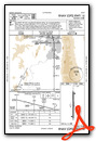
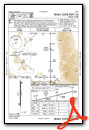
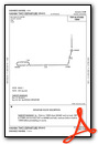
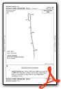
Departure Procedure (DP) Charts
Nearby Airports with Instrument Procedures
| ID | Name | Heading / Distance | ||
|---|---|---|---|---|
 |
8S1 | Polson Airport | 336° | 8.4 |
|
KMSO | Missoula Montana Airport | 179° | 39.1 |
|
KGPI | Glacier Park International Airport | 352° | 45.1 |
|
32S | Stevensville Airport | 178° | 62.6 |
|
S59 | Libby Airport | 308° | 70.7 |
|
KHRF | Ravalli County Airport | 180° | 78.6 |
|
KCII | Choteau Airport | 077° | 79.9 |
|
38S | Deer Lodge-City-County Airport | 141° | 89.6 |
|
S01 | Conrad Airport | 066° | 93.1 |
|
KCTB | Cut Bank International Airport | 047° | 93.4 |
|
3U3 | Bowman Field Airport | 148° | 98.9 |
|
KHLN | Helena Regional Airport | 122° | 104.2 |
Airport Images

By: Big Orange Bird


