Login
Register


GPI
Glacier Park International Airport
Official FAA Data Effective 2025-12-25 0901Z
Chart Supplement

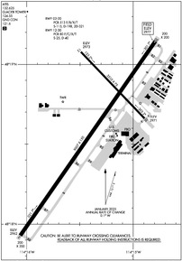
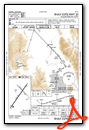
KGPI Airport Diagram
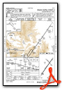
VFR Chart of KGPI
Sectional Charts at SkyVector.com
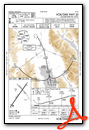
IFR Chart of KGPI
Enroute Charts at SkyVector.com
Location Information for KGPI
Coordinates: N48°18.63' / W114°15.36'Located 06 miles NE of Kalispell, Montana on 1525 acres of land. View all Airports in Montana.
Surveyed Elevation is 2976 feet MSL.
Operations Data
|
|
Airport Communications
| ATIS: | 132.625 |
|---|---|
| ASOS: | 132.625 Tel. 406-233-0175 |
| GLACIER TOWER: | 124.55 |
| GLACIER GROUND: | 121.6 |
| UNICOM: | 122.950 |
| CTAF: | 124.550 |
| AWOS-3 at 7S0 (45.0 S): | 119.925 406-676-2967 |
| AWOS-A at S59 (49.4 W): | 118.575 406-293-4631 |
| AWOS-3PT at S34 (56.7 SW): | 118.1 406-826-5784 |
- APCH/DEP CTL SVC PRVDD BY SALT LAKE ARTCC (ZLC) ON FREQS 127.075/244.875 (LAKESIDE RCAG).
- COMMUNICATIONS PRVDD BY GREAT FALLS RADIO ON FREQ 122.5 (LAKESIDE RCO).
Nearby Navigation Aids
|
| ||||||||||||||||||||||||||||||||||||


Runway 02/20
| Dimensions: | 9007 x 150 feet / 2745 x 46 meters | |
|---|---|---|
| Surface: | Asphalt / Grooved in Good Condition | |
| Weight Limits: | S-115, D-198, ST-321
PCR VALUE: 513/F/B/X/T
| |
| Edge Lighting: | High Intensity | |
| Runway 02 | Runway 20 | |
| Coordinates: | N48°17.93' / W114°16.06' | N48°19.14' / W114°14.79' |
| Elevation: | 2962.3 | 2976.7 |
| Traffic Pattern: | Left | Left |
| Runway Heading: | 35° True | 215° True |
| Declared Distances: | TORA:9007 TODA:9007 ASDA:9007 LDA:9007 | TORA:9007 TODA:9007 ASDA:9007 LDA:9007 |
| Markings: | Precision Instrument in good condition. | Precision Instrument in good condition. |
| Glide Slope Indicator | P4L (3.00° Glide Path Angle) | P4L (3.00° Glide Path Angle) |
| Approach Lights: | MALSR 1,400 Foot Medium-intensity Approach Lighting System with runway alignment indicator lights. | |
| REIL: | Yes | |
Runway 12/30
| Dimensions: | 3510 x 75 feet / 1070 x 23 meters | |
|---|---|---|
| Surface: | Asphalt / Grooved in Good Condition | |
| Weight Limits: | S-25, D-40
PCR VALUE: 80/F/C/X/T
| |
| Edge Lighting: | Medium Intensity | |
| Runway 12 | Runway 30 | |
| Coordinates: | N48°19.08' / W114°15.49' | N48°18.66' / W114°14.89' |
| Elevation: | 2972.9 | 2971.4 |
| Traffic Pattern: | Left | Left |
| Runway Heading: | 136° True | 316° True |
| Declared Distances: | TORA:3510 TODA:3510 ASDA:3510 LDA:3510 | TORA:3510 TODA:3510 ASDA:3510 LDA:3510 |
| Markings: | Non-Precision Instrument in good condition. | Non-Precision Instrument in good condition. |
| Glide Slope Indicator | P2L (3.50° Glide Path Angle) | |
Services Available
| Fuel: | 100LL (blue), Jet-A |
|---|---|
| Transient Storage: | Hangars,Tiedowns |
| Airframe Repair: | MAJOR |
| Engine Repair: | MAJOR |
| Bottled Oxygen: | NOT AVAILABLE |
| Bulk Oxygen: | HIGH/LOW |
| Other Services: | AVIONICS,CHARTER SERVICE,PILOT INSTRUCTION,AIRCRAFT RENTAL,ANNUAL SURVEYING |
Ownership Information
| Ownership: | Publicly owned | |
|---|---|---|
| Owner: | FLATHEAD MUNI ARPT AUTHORITY | |
| 4170 HWY 2 | ||
| KALISPELL, MT 59901 | ||
| 406-257-5994 | ||
| Manager: | ROB RATKOWSKI | |
| 4170 HWY 2 | ||
| KALISPELL, MT 59901 | ||
| 406-257-5994 | ||
Other Remarks
- COLD TEMPERATURE AIRPORT. ALTITUDE CORRECTION REQUIRED AT OR BELOW -14C.
- CTN: SKYDIVING OPS 6 NM NW 13000 FT & BLW SR-SS JUN-SEP. PAJA STATUS - SALT LAKE ARTCC.
- CTN: VFR TFC OPS AT KALISPELL CITY ARPT 8 NM S & WHITEFISH ARPT 6 NM NW.
- ACTVT MALSR RWY 02; REIL RWY 20; HIRL RWY 02/20; MIRL RWY 12/30 - CTAF. PAPI RWY 02, 20 & 30 OPR CONSLY.
Weather Minimums

Instrument Approach Procedure (IAP) Charts
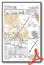

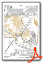
Departure Procedure (DP) Charts

Departure Procedure Obstacles (DPO) Charts
Nearby Airports with Instrument Procedures
| ID | Name | Heading / Distance | ||
|---|---|---|---|---|
 |
8S1 | Polson Airport | 175° | 37.0 |
|
7S0 | Ronan Airport | 171° | 45.1 |
|
S59 | Libby Airport | 268° | 49.5 |
|
CZPC | Pincher Creek Airport | 007° | 73.4 |
|
KCTB | Cut Bank International Airport | 075° | 77.2 |
|
KMSO | Missoula Montana Airport | 175° | 84.0 |
|
65S | Boundary County Airport | 287° | 85.1 |
|
KCII | Choteau Airport | 108° | 88.9 |
|
S01 | Conrad Airport | 094° | 91.8 |
|
KSZT | Sandpoint Airport | 270° | 92.3 |
|
KSBX | Shelby Airport | 080° | 96.3 |
|
32S | Stevensville Airport | 175° | 107.5 |
Airport Images
Do you have a recent image of this airport? Upload it here!


