Login
Register


CTB
Cut Bank International Airport
Official FAA Data Effective 2026-01-22 0901Z
Chart Supplement

VFR Chart of KCTB
Sectional Charts at SkyVector.com
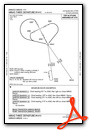
IFR Chart of KCTB
Enroute Charts at SkyVector.com
Location Information for KCTB
Coordinates: N48°36.50' / W112°22.57'Located 03 miles SW of Cut Bank, Montana on 1730 acres of land. View all Airports in Montana.
Surveyed Elevation is 3857 feet MSL.
Operations Data
|
|
Airport Communications
| ASOS: | 119.025 Tel. 406-873-2939 |
|---|---|
| CTAF: | 123.000 |
| UNICOM: | 123.000 |
| AWOS-3PT at SBX (20.5 E): | 128.325 406-434-2542 |
| AWOS-2 at CII (47.7 S): | 119.275 406-466-2259 |
| ASOS at GPI (76.9 W): | 132.625 406-233-0175 |
- APCH/DEP CTL SVC PRVDD BY SALT LAKE CITY ARTCC ( ZLC) ON FREQS 133.4/285.4 (GREAT FALLS RCAG).
Nearby Navigation Aids
|
| ||||||||||||||||||||||||||||||||||||


Runway 05/23
| Dimensions: | 5300 x 75 feet / 1615 x 23 meters | |
|---|---|---|
| Surface: | Asphalt in Excellent Condition | |
| Weight Limits: | 10 /F/D/Y/U, S-27, D-37 | |
| Edge Lighting: | Medium Intensity | |
| Runway 05 | Runway 23 | |
| Coordinates: | N48°36.39' / W112°23.11' | N48°36.77' / W112°21.93' |
| Elevation: | 3853.8 | 3840.1 |
| Traffic Pattern: | Left | Left |
| Runway Heading: | 64° True | 244° True |
| Markings: | Non-Precision Instrument in good condition. | Non-Precision Instrument in good condition. |
| Glide Slope Indicator | P2L (3.00° Glide Path Angle) | |
Runway 14/32
| Dimensions: | 5300 x 75 feet / 1615 x 23 meters | |
|---|---|---|
| Surface: | Asphalt in Excellent Condition | |
| Weight Limits: | 10 /F/D/Y/U, S-27, D-37 | |
| Edge Lighting: | Medium Intensity | |
| Runway 14 | Runway 32 | |
| Coordinates: | N48°36.81' / W112°22.92' | N48°36.04' / W112°22.31' |
| Elevation: | 3857.8 | 3841.6 |
| Traffic Pattern: | Left | Left |
| Runway Heading: | 152° True | 332° True |
| Markings: | Non-Precision Instrument in good condition. | Non-Precision Instrument in good condition. |
| Glide Slope Indicator | V4L (3.00° Glide Path Angle) | |
| REIL: | Yes | |
Services Available
| Fuel: | 100LL (blue), Jet-A, Jet A+ |
|---|---|
| Transient Storage: | Hangars,Tiedowns |
| Airframe Repair: | NONE |
| Engine Repair: | NONE |
| Bottled Oxygen: | NONE |
| Bulk Oxygen: | NONE |
| Other Services: | CROP DUSTING SERVICES,PILOT INSTRUCTION |
Ownership Information
| Ownership: | Publicly owned | |
|---|---|---|
| Owner: | CITY OF CUT BANK AND GLACIER COUNTY | |
| P.O. BOX 130 | ||
| CUT BANK, MT 59427 | ||
| 406-873-8683 | ||
| Manager: | TOM REDFIELD | |
| P.O. BOX 130 | ||
| CUT BANK, MT 59427 | ||
| 406-873-8683 | ||
Other Remarks
- FOR FUEL AFT HRS CALL 406-873-8683 OR 406-849-4245 CELL.
- 24 HOUR CUSTOMS AVBL ON CALL-OUT 406-335-9610 EXT. 314.
- FOR CD IF UNA TO CTC ON FSS FREQ, CTC SALT LAKE ARTCC AT 801-320-2568.
- COLD TEMPERATURE AIRPORT. ALTITUDE CORRECTION REQUIRED AT OR BELOW -28C.
- (CONTACT TITLE) EMAIL: CBAA_MT@YAHOO.COM
- ACTVT MIRL RWY 05/23 & 14/32; REIL RWY 32 - CTAF. PAPI RWY 23; VASI RWY 32 OPR CONSLY.
Weather Minimums

Instrument Approach Procedure (IAP) Charts
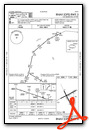
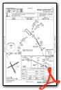

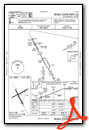

Departure Procedure (DP) Charts
Nearby Airports with Instrument Procedures
| ID | Name | Heading / Distance | ||
|---|---|---|---|---|
 |
KSBX | Shelby Airport | 101° | 20.5 |
|
S01 | Conrad Airport | 148° | 30.9 |
|
KCII | Choteau Airport | 169° | 47.6 |
|
KGPI | Glacier Park International Airport | 257° | 77.2 |
|
KGTF | Great Falls International Airport | 148° | 78.8 |
|
79S | Fort Benton Airport | 122° | 83.5 |
|
CZPC | Pincher Creek Airport | 311° | 84.2 |
|
8S1 | Polson Airport | 233° | 91.0 |
|
7S0 | Ronan Airport | 228° | 93.4 |
|
KHVR | Havre City-County Airport | 091° | 104.2 |
|
KMSO | Missoula Montana Airport | 214° | 123.0 |
|
S64 | Stanford/Biggerstaff Field Airport | 134° | 123.3 |
Airport Images
Do you have a recent image of this airport? Upload it here!


