Login
Register


82C
Mauston/New Lisbon Union Airport
Official FAA Data Effective 2025-11-27 0901Z
Chart Supplement

VFR Chart of 82C
Sectional Charts at SkyVector.com
IFR Chart of 82C
Enroute Charts at SkyVector.com
Location Information for 82C
Coordinates: N43°50.33' / W90°8.26'Located 03 miles SE of New Lisbon, Wisconsin on 248 acres of land. View all Airports in Wisconsin.
Surveyed Elevation is 907 feet MSL.
Operations Data
|
|
Airport Communications
| AWOS-3: | 123.925 Tel. 608-562-6153 |
|---|---|
| VOLK APPROACH: | 135.25 244.875 |
| VOLK DEPARTURE: | 135.25 244.875 |
| CTAF: | 122.900 |
| ATIS at VOK (7.8 NW): | 134.35 |
| AWOS-3PT at C35 (20.0 S): | 118.95 608-768-0023 |
| AWOS-3 at DLL (24.7 SE): | 118.325 608-356-1071 |
- APCH/DEP SVC PRVDD BY CHICAGO ARTCC (ZAU) ON FREQS 125.05/269.375 (CAMP DOUGLAS RCAG) WHEN VOLK APCH CTL CLSD.
Nearby Navigation Aids
|
| ||||||||||||||||||||||||||||||||||||||||||||||||||||||


Runway 14/32
| Dimensions: | 3688 x 75 feet / 1124 x 23 meters | |
|---|---|---|
| Surface: | Asphalt in Excellent Condition | |
| Edge Lighting: | Medium Intensity | |
| Runway 14 | Runway 32 | |
| Coordinates: | N43°50.56' / W90°8.54' | N43°50.10' / W90°7.99' |
| Elevation: | 907.8 | 898.8 |
| Traffic Pattern: | Left | Left |
| Runway Heading: | 139° True | 319° True |
| Markings: | Non-Precision Instrument in good condition. | Non-Precision Instrument in good condition. |
| Glide Slope Indicator | V2L (3.50° Glide Path Angle) VASI UNUSBL BYD 8 DEGS LEFT OF CNTRLN. | V2L (4.00° Glide Path Angle) VASI UNUSBL BYD 6 DEGS RIGHT OF CNTRLN. |
| Obstacles: | 23 ft Road 420 ft from runway, 250 ft left of center | |
Services Available
| Fuel: | 100LL (blue), Jet A+ |
|---|---|
| Transient Storage: | Tiedowns |
| Airframe Repair: | NONE |
| Engine Repair: | NONE |
| Bottled Oxygen: | NONE |
| Bulk Oxygen: | NONE |
| Other Services: | PILOT INSTRUCTION,AIRCRAFT RENTAL |
Ownership Information
| Ownership: | Publicly owned | |
|---|---|---|
| Owner: | MAUSTON&NEW LISBON UNION CITY | |
| CITY HALL | ||
| MAUSTON, WI 53948 | ||
| 608-847-6676 | ||
| Manager: | DAVID SEITZ | ADDNL AMGR VONDA BENSON, 608-853-3233. |
| W7493 FERDON RD | ||
| NEW LISBON, WI 53950 | ||
| 608-547-2227 | ||
Other Remarks
- DEER AND OTHER WILDLIFE ON & INVOF ARPT.
- FOR CD CTC CHICAGO ARTCC AT 630-906-8921.
- PARAGLDR & ULTRALIGHT ACT ON ARPT.
- 0LL FUEL AVBL 24 HRS WITH CREDIT CARD.
- MIRL RWY 14/32 PRESET TO LOW SS-SR; TO INCR INTST AND ACTVT VASI RWY 14 & 32 - CTAF.
Weather Minimums
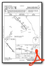
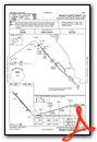
Instrument Approach Procedure (IAP) Charts
Nearby Airports with Instrument Procedures
| ID | Name | Heading / Distance | ||
|---|---|---|---|---|
 |
KVOK | Volk Field Airport | 320° | 7.8 |
|
KDAF | Necedah Airport | 011° | 11.9 |
|
63C | Adams County Legion Field Airport | 064° | 16.8 |
|
Y72 | Bloyer Field Airport | 299° | 17.0 |
|
C35 | Reedsburg Municipal Airport | 160° | 19.9 |
|
KDLL | Baraboo/Wisconsin Dells Regional Airport | 139° | 24.8 |
|
KCMY | Sparta/Fort Mc Coy Airport | 285° | 27.0 |
|
C47 | Portage Municipal Airport | 120° | 33.0 |
|
KISW | Alexander Field South Wood County Airport | 022° | 33.9 |
|
93C | Richland Airport | 191° | 34.0 |
|
Y51 | Viroqua Municipal Airport | 245° | 36.5 |
|
91C | Sauk/Prairie Airport | 152° | 36.5 |
Airport Images
Do you have a recent image of this airport? Upload it here!


